Esri Software Helps Collins Bartholomew Bring Atlas Production into the 21st Century
By Karen Richardson, Esri Writer
The Times Comprehensive Atlas of the World epitomizes the beauty and power of GIS software. Published by Collins Bartholomew and painstakingly researched by a dedicated team of more than 50 cartographers, the atlas is fully up-to-date, stylish, and contemporary, continuing as the leading authority with its selection of detailed maps and an index of more than 200,000 places and features.
The effort put into this publication was monumental, with changes to the database made on average every three and a half minutes using a 24-hour-a-day feed and validated by information from approximately 500 organizations and experts. New maps and geographic publications from government departments, agencies, business offices, and experts around the world provided information for every country on a variety of topics.
 |
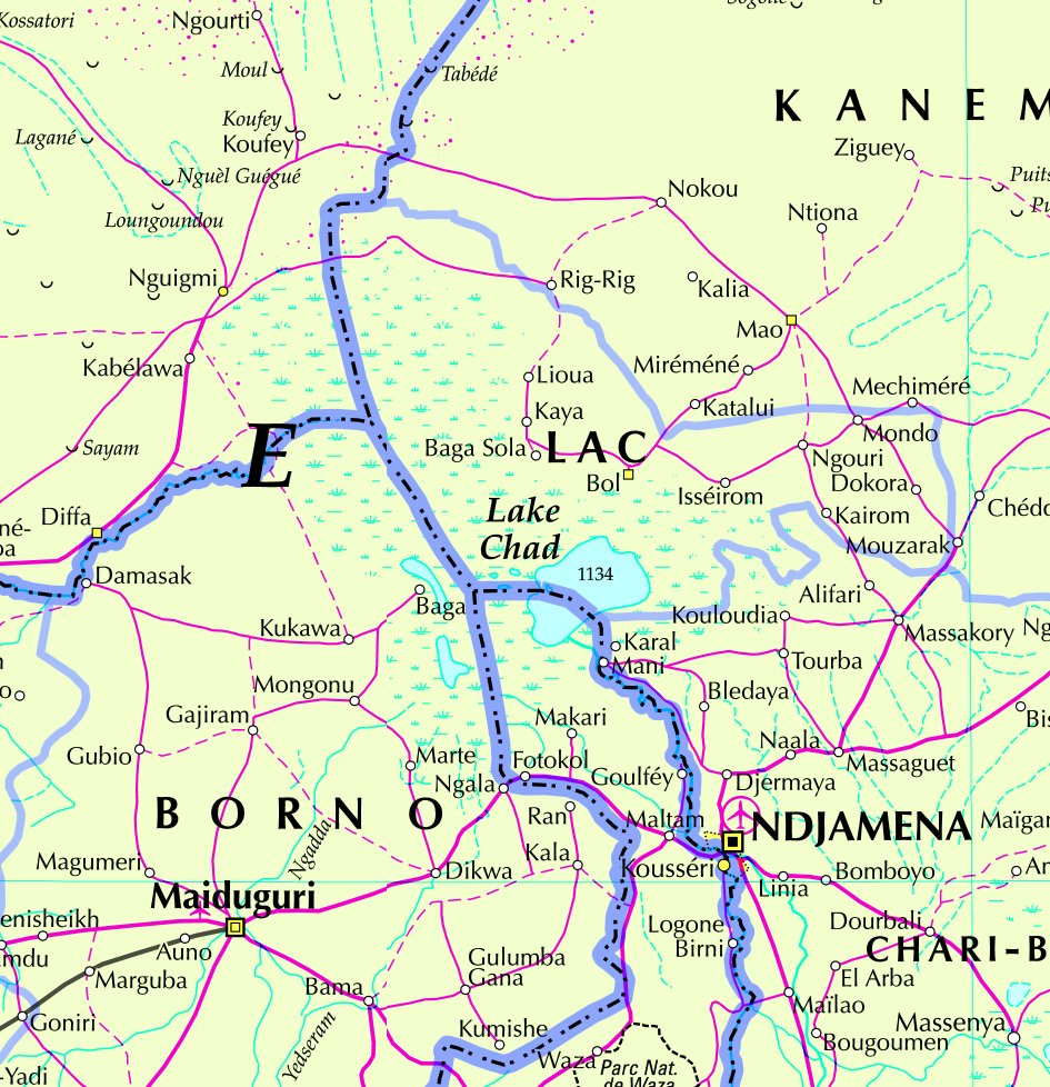 |
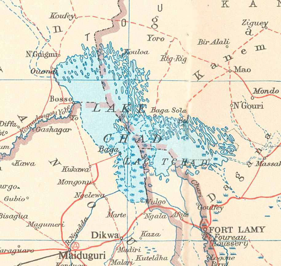
| These maps from the Times Atlas of 1973 and the new 12th Edition published in 2007 show the dramatic changes which have happened to Lake Chad in Africa over the last thirty-five years. The lake has shrunk to a fraction of its former size as a result of water extraction for irrigation schemes and recent severe droughts. | |
ArcGIS Software Used to Produce Atlas
Collins Bartholomew, based in Great Britain, has published a long line of universally acclaimed world atlases, the latest being The Times Atlas of the World Mid-Century Edition, published in five volumes between 1955 and 1960. Those set the standard for world atlas publishing. In 1967, they were reworked into a single volume as The Times Comprehensive Atlas of the World, which continues to be the world's leading reference atlas. The 12th edition has just been published using GIS software and seeing significant improvements in costs and production methods.
The company's move to GIS was driven by the need to find a more efficient way to update The Times Comprehensive Atlas of the World. The atlas needed to be constantly maintained and brought up-to-date to reflect physical changes of the earth as well as to present a balanced view of the geopolitical landscape. To update this all-encompassing book in a timely manner, Collins Bartholomew sought the most appropriate software. After researching available technology solutions, Collins Bartholomew purchased Esri's ArcGIS, a complete GIS for data building and editing, and Maplex, sophisticated, high-end cartographic design software from Esri that's used for creating quality labeling and annotation text for making maps. This solution allows Collins Bartholomew to automate, store, edit, and manage all of its spatial data in one location, an Oracle database running on a Windows 2000 network with large-format HP Designjet plotters for hard-copy output.
Efficient Data Storage and Cartographic Labeling
ArcGIS helps facilitate production of many valuable analytical and cartographic products more efficiently than was possible before. Data stored in the geodatabase can be versioned, allowing multiple users to carry out simultaneous updates including long transactions. This prevents unnecessary locking of data layers and the creation of superfluous copies of data. "With versioning, it is easier to create cartographic product generation and map finishing, meeting publishing deadlines while continuing in parallel with ongoing database updates," says Sheena Barclay, executive director, Collins Bartholomew.
Esri's ArcSDE technology, a component of both ArcGIS Desktop and ArcGIS Server, acts as the database access engine to spatial data, its associated attributes and metadata stored within a relational database management system. It provides access to the geodatabase. It operates as the gateway, facilitating spatial data in a database management system and providing efficient storage of continuous map data with spatial searches and transaction locking.
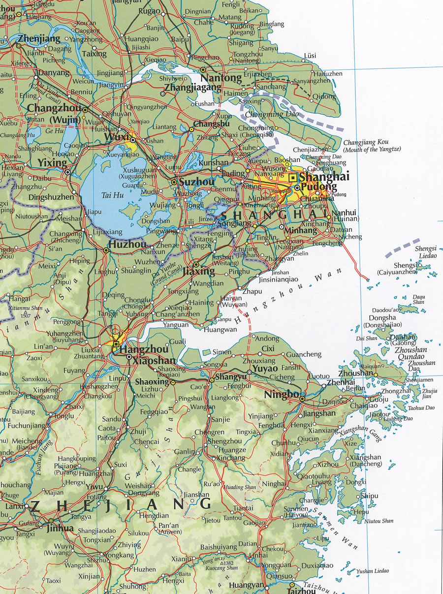
 The area around Shanghai in southeast China has seen enormous development recently, as evident in these maps from the Times Atlas of 1992 and the new 12th Edition published in 2007. Development of the communications network has included the building of the Donghai Bridge—the longest trans-oceanic bridge in the world. |
 |
By using a database-centric approach, Collins Bartholomew updated the atlas in record time. Having the data available for selection, classification, and extraction depending on the map scale or theme has made the job more efficient. "The database needs to be as flexible as possible in terms of what features are contained, how features can be symbolized, and more," says Barclay. "Using ArcGIS and Maplex, we are able to use the data any way we need it, quickly and easily. We are saving a lot of time, and time is money."
After the data is updated and edited in the geodatabase, cartographers use Maplex labeling software for text placement. Once a time-consuming and laborious process, labeling tasks are now automated. Collins Bartholomew has found that it is completing this part of the mapmaking process 90 percent faster.
As any cartographer will tell you, symbolization is the heart of cartography. ArcGIS Desktop provides a rich set of functions to define and apply different symbolization styles to point, line, and area data. ArcGIS Desktop includes vector and bitmapped symbols, line styles allowing patterned and pecked lines with control over end and join styles, and areas filled with either solid color or patterns. Raster symbolization is also a strong point, with capabilities important to cartography such as terrain height banding and hillshading.
Vector symbolization can be a complex process, with representation being built up by drawing multiple representation parts, each with its own drawing priority level. Enhancements in ArcGIS Desktop 9.2 include new group layers and symbol level controls, which together allow clean handling of standard cartographic styles such as road casings and under and over sections such as road bridges and tunnels. Symbolization is not determined solely by the feature class but also by combinations of attributes, allowing exceptions for categories such as "primary dual road under construction."
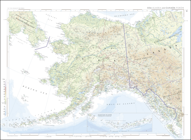 This new map of Alaska shows the highly distinctive and widely respected 'Times' style of atlas mapping—a blend of accuracy, authority, and great cartographic style. |
The Times Atlas team carefully validates spelling and attribution of place-names and the depiction of disputed boundaries, a contentious undertaking. Taking care to present the information accurately and impartially, a policy committee meets regularly to decide the correct spelling of names and the introduction of new forms. The committee also scrutinizes new and disputed international and administrative boundaries and decides on the best way of portraying them. The committee also sets policies as to preferred sources and their use for specific geographic information—in particular, geographic statistics, flags, currencies, languages, and religions. Crucially, it decides how any policies should then be applied to the atlas, the databases, and other products and disseminates its decisions to all interested parties, offering guidance as necessary.
Data Shows Many Changes on Earth
The data for the new edition of the atlas, published in September 2007, reveals interesting information on climate change and its effects on the earth, the urbanization of world population, environmental changes, and the dramatic growth of China. This edition reveals the deadliest earthquakes and the increase in the earth's temperature and provides data updates such as mortality and life expectancy rates around the world. Some other interesting callouts from this comprehensive tome of data include the following:
- The Aral Sea in Central Asia has shrunk by 75 percent since 1967.
- China is now the most heavily populated country in the world, with more than 1.3 billion people-one fifth of the world's population.
- The mouth of the Yellow River has changed shape due to China's increasingly dry climate and water extraction to support the growing population.
- Plymouth, Montserrat, was abandoned due to volcanic activity. This former capital was buried in volcanic ash when the Soufri�re Hills volcano erupted between 1995 and 1997. Five thousand people were evacuated and the city abandoned.
- By 2030, three in five people (59.9 percent) will be urbanites, and the global urban population is expected to grow to 4.9 billion (from 1.33 billion in 1970).
- Thirteen percent of the world's land surface (19 million km2) is now within more than 107,000 designated Protected Areas worldwide.
- In less-developed countries, such as Sierra Leone, Afghanistan, and Liberia, an average of 87 out of every 1,000 babies die before their first birthday, compared to only 6 in North America.
- The lowest country in the world—Tuvalu, in the Pacific Ocean—is only five meters above sea level at its highest point. The country is already feeling the effects of sea levels rising and may one day be wiped from the map completely.
- Quick Atlas Turnaround
Using ArcGIS, Collins Bartholomew produced the atlas in less than 12 months. This in turn gave the company the flexibility to create new and innovative data offerings, expanding its overall product line to more than 200 products. Incremental revenue from the new products amounted to more than $5 million (U.S.). Data products include digital maps of the world, Great Britain, Europe, London, and others, with an extensive authoritative gazetteer of more than 800,000 names. Atlas data includes detailed administrative coverage, lakes and other bodies of water, topography, urban areas, roads, national and regional parks, and rail and ferry locations.
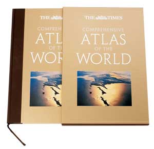 The new edition is highly distinctive with a striking golden finish. With 544 pages, measuring 18 x 12 � inches, weighing 5.8 kg, and with over 200,000 place names in its index, this is an impressive product in every way. |
"We have used GIS to increase throughput and to lower the cost of map production," says Barclay. "Equally important, we now have a more creative and flexible range of products. We can use GIS to target specific needs and produce solutions based on those needs. New markets are opening up for geographic information. Aided by Esri solutions, Collins Bartholomew is positioned to capitalize on these new opportunities."
Now Collins Bartholomew can use Esri software for virtually every step of production. This data-centric approach to mapmaking has truly revolutionized Collins Bartholomew's workflow. Instead of a conventional, manual, title-by-title approach, the company's new style of a database-centered, digital workflow has made the company responsive to the many factors contemporary mapmakers face today.
About Collins Bartholomew
Since John Bartholomew set up as a map engraver in Edinburgh, Scotland, in 1826, Collins Bartholomew has been one of the world's leading cartographic companies. As well as being one of the world's foremost cartographic publishers, publishing atlases and maps under the Times and Collins brands, the company is a leading provider of map products and geographic data to other publishers and to commercial organizations and agencies worldwide. Employing more than 50 cartographers at its Glasgow, Scotland, and Cheltenham, England, offices, Collins Bartholomew is dedicated to providing the most accurate and up-to-date maps available.
For more information, contact Mick Ashworth, Editor in Chief, Collins Geo, HarperCollins Publishers at +44 141 306 3487 or mick.ashworth@harpercollins.co.uk.