GIS Aids Petroleum Exploration and Reservoir Analysis in Romania
By Manuela Badea, Elena Nedelcu, and Mihaela Pop, Petrom
Petrom S.A., the largest oil and gas group in Romania and a member of the oil and gas group OMV, uses Esri's ArcGIS Server to support exploration and production (E&P) operations.
 Petrom employees access reports and visualize petroleum field data via the company's intranet. |
Petrom wanted to allow more of its employees to take advantage of its image-rich database. Therefore it launched a GIS-enabled Web site built on ArcGIS Server technology. The new system allows designated users to quickly access the information they need. Using ArcGIS Server and an Oracle relational database management system (RDBMS) Petrom now has an enterprise geodatabase that maintains all information in one common location. This has also significantly improved data security and increased the efficiency of the oil company's workflows.
Petrom began its GIS project by preparing its data for migration into the system. In 2006, the company defined its database structure and began scanning and organizing data into the Petrom geodatabase. This database holds a wide variety of data including geological maps (1:200,000), exploration and exploitation blocks, organization assets, field clusters, sectors, seismic lines and 3D contours, and offshore and onshore surfaces. To start the project, Petrom focused on data from its east region exploration block by scanning structural reports, resource maps, and situation plans. Staff also georeferenced the data so it could be attached to coordinates. Then this data was added to the geodatabase. In addition, staff georeferenced and added E&P site assets such as water treatment stations, oil processing and deposit sites, gas tank farms and facilities, and compressor stations. Regional datasets, such as localities, roads, lakes, the River Danube attributes, and county and country boundaries, and a digital elevation model were included. The geodatabase also contains orthophotos for the entire country.
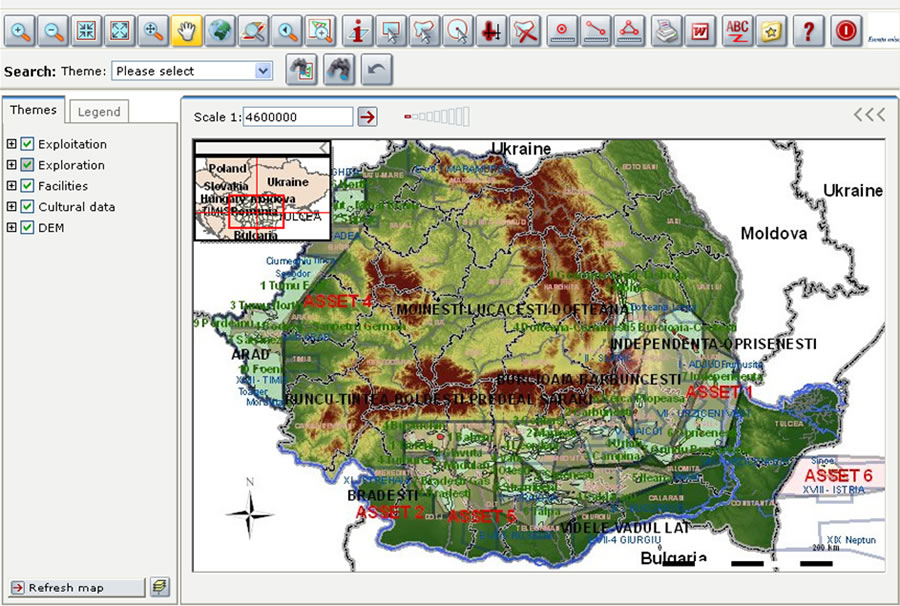
 The Web map viewer allows staff to see well data on a map. Here, layers for blocks, seismic, regional, and topographic data are turned on. |
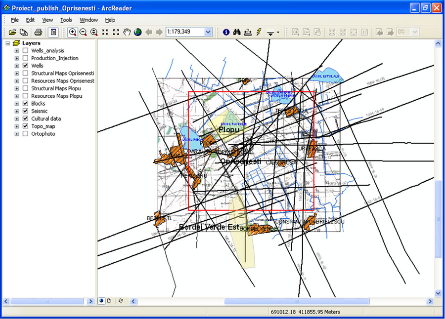
A key feature of the system is WebOffice, which is a Java Web application developed by SynerGIS Informationssysteme GmbH, Esri's distributor in Austria. It runs on ArcGIS Server along with any other operating system that supports the same Java specification. This provides seamless integration of the GIS server with the company's core IT systems. Moreover, the system makes it possible for users to readily access important files and onshore/offshore data for local projects. It offers a Web data viewer via Esri's ArcReader, a read-only viewer that allows the user to interact with the corporate database and use basic mapping tools such as Zoom and Pan.
The majority of users at Petrom access the data to work on reservoir and commercial field projects. For example, geologists will use GIS to analyze the potential production from a new well. The database contains well coordinates in the context of structural, geological, and cadastral data layers that can be brought directly into the user's GIS project. The geologist can also bring other data into the project such as seismic lines and orthophotography.
Business managers were concerned about security. A feature in ArcGIS Server allows company's GIS managers to control access rights to the WebOffice application according to their hierarchical levels. They can add as much detail as they deem necessary. They can also define levels of access to applications, data layers, and even to object data within the layers. A user queries the system and the program checks and filters the query according to the role granted to the user before the GIS is allowed to respond to the query.
Petrom partner OMV's analysts use GIS to create structural and resource maps as well as cumulative oil, gas production, and water injection maps. Staff can perform well analyses and create both geographic and table reports. Data on maps can be further linked to other data in the legacy database. Users can quickly view files with presentation and well analysis data along with scanned images.
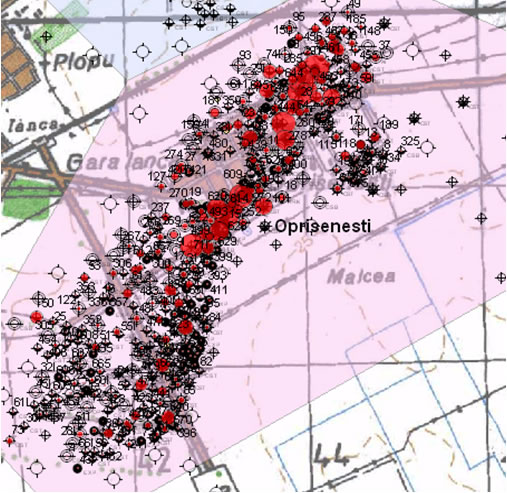 E&P database visualization shows well location and relevant symbology. |
An advantage that Petrom found with Esri's ArcGIS software is that users can analyze many different types of data such as satellite imagery, digital aerial photomosaics, seismic surveys and interpretations, surface geology studies, subsurface and cross section interpretations and images, well locations, and existing infrastructure information. This ability to use a variety of data formats removes limitations on data types and opens a wide vista of research resources for GIS use. Moreover, it makes it possible to overlap and analyze data from many sources in a comprehensive and effective way.
Because data integration is a powerful function of ArcGIS, Petrom has been able to use the database for more than the standard E&P requirements. For example, the user can select wells on the digital map and access extended attributes from a wide array of tables in the well database. Simultaneously, the user can display a data log and visualize cross-sectional information.
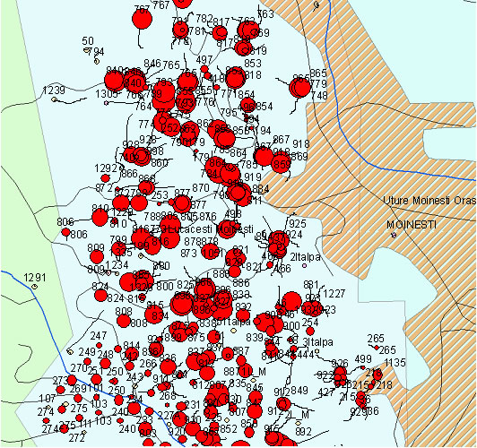 GIS lets users easily understand well data. This map shows cumulative production per well. |
Working with external companies, agencies, and contractors, Petrom receives and delivers data in a variety of file formats such as CAD. This data is migrated to a GIS format so it can be processed. This incoming data is validated in the GIS so it is accurate and useful for geospatial processing. Thus, a wide range of data can be used for field and business practices such as understanding asset infrastructures, business conditions, and environmental factors.
Petrom's petroleum and facility engineers, geologists, and geophysicists can now combine many pieces of information, including well profiles, surface topography, surface maps, and other features, that allow them to test multiple scenarios for selecting and designing field assets. For more information about Petrom S.A.'s GIS, contact Elena Nedelcu, GIS senior application expert, at elena.nedelcu@petrom.com.