ArcWatch: Your e-Magazine for GIS News, Views, and Insights
February 2011
Mapping the Market to Create Healthy Banks
SNL Financial Incorporates Esri's ArcGIS to Give Its Customers a Better View of Financial Practices
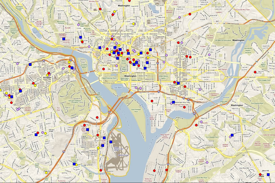
SNL Financial's clients can quickly visualize their branch locations against the locations of competitors and see the possibility for growth through mergers and acquisitions.
For the past two decades, SNL Financial (SNL) has built a strong reputation for providing accurate and up-to-date financial data, news, and insight. Clients of the Charlottesville, Virginia-based company include leading investment banks; asset managers; banks and thrifts, and regulatory agencies. The company is frequently quoted by major media publications such as the Wall Street Journal, the New York Times, and USA TODAY.
SNL collects, standardizes, and disseminates specialized business information for the banking, financial services, insurance, real estate, and energy industries through its SNL Interactive (SNLi) web portal. The portal includes SNLi Mapping, a mapping application delivered to subscribers of the portal. SNLi Mapping uses Esri's ArcGIS software to view and analyze information on a map.
Mapping Business Worth
SNL started to incorporate ArcGIS software and Esri data in its product in order to offer customers detailed GIS and analytic functionality. The analytic tools SNL's customers wanted were readily available in ArcGIS. The functionality lets their clients view various types of data, including street information and aerial images, and gives them the ability to create new data, such as adding new market areas, and incorporate information on demographics and business data. SNLi Mapping incorporates these features, creating intuitive market analysis and visualization tools for subscribers. The website services allow subscribers to identify locations of assets, perform competition searches, and generate in-depth or ad hoc analyses as needed.
SNLi Mapping proved popular with subscribers, and SNL was delighted with the success of the online mapping service. "Clients find visualizing information on a map to be very useful," says Dan Sheets, project manager, SNL Financial. "Using this tool, the information they need really pops out at them."
Using SNLi Mapping, subscribers have been able to better evaluate companies' mergers and acquisitions and make more informed decisions. They are performing their own market analyses and integrating demographic data with geographic information such as the location of major cities, interstate highways, and company buildings. Many subscribers also use SNLi Mapping for making presentations because of the high quality of the mapping capabilities.
"Having all this information integrated makes it easy for them to understand market valuation and why a particular location or company may be more attractive than another," says Sheets.
GIS Analytics Moves to Banking
Based on the success of SNLi Mapping, the company incorporated GIS visualization and analysis into Branch Analytics, a different web-based application that was created specifically to analyze bank markets. Branch Analytics allows customers to quickly perform in-depth market studies integrating bank branch deposit and demographic data. SNL expanded its use of Esri's ArcGIS software to create and deliver the geographic visualization and analysis.
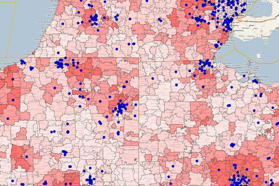
Users can quickly see their branches plotted with hundreds of demographic variables that Esri provides, helping them to better understand their markets and opportunities for growth.
Clients for the application range from newly chartered banks to superregional institutions that cover large areas of the United States. They use SNLi daily to make important strategic decisions such as where to locate new branches, how to increase market share, and what products to offer to customers. Using Branch Analytics, they can access SNL's database filled with detailed profiles on more than 20,000 United States financial companies, including all publicly traded banks and thrifts, privately held institutions, and credit unions. Subscribers can quickly search for 150,000 branch locations and plot them on maps using the latitude and longitude of the bank location, which is derived from the reported branch address and validated by SNL's Branch Data Management team using a variety of sources. Demographic and business summary data is provided annually by Esri.
"SNL is the trusted information partner for all of the top 50 depositories in the [United States] as well as hundreds of regional and community banks," says Elizabeth Rouse, product manager for branch and geographic intelligence at SNL Financial. "And 100 percent of investment banks with any substantive financial institution industry practice are SNL subscribers."
Powerful GIS Analytics on the Web
Subscribers can use Branch Analytics to delve deep into the marketplace and find the best solution for maintaining a healthy balance sheet. Changes in market deposit concentration can be viewed using the service, allowing them to model what-if scenarios such as what would happen if they opened new branches, offered different services, or closed underperforming sites. They can use the application to model such bank-specific activities as the acquisition of other bank branches and change attributes on the fly, including adjusting ownership for recently announced business transactions. Custom geographic markets can be created as well, to see the effects of all these activities in the real world.
Banking professionals can create maps using SNL data and customize them for use in professional documents and presentations. This is easily accomplished by creating a report with Branch Analytics.
Maps can also be created after generating a report. Subscribers simply create a Branch Analytics report, for example, looking at company market share in an area, and the application automatically exports the analysis to a map. As information is updated, or the analysis is customized, the maps dynamically absorb the changes to reflect the adjusted report.
"This has been a powerful tool for our customers," says Rouse. "Visualizing and modeling business practices helps our customers make the best strategic decisions and better understand the markets they operate in."
For more information, visit esri.com/finance.