ArcWatch: Your e-Magazine for GIS News, Views, and Insights
February 2011
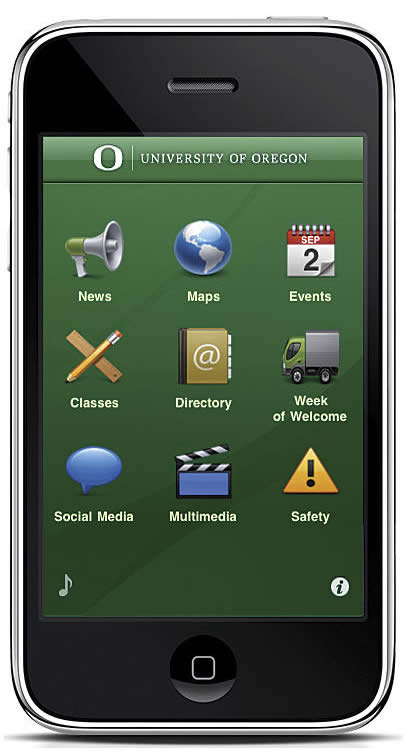
Campus iPhone App Helps University of Oregon Students Negotiate Their Way around Campus
Application Was Created Using ArcGIS API for iOS
The new UOregon iPhone app offers an alternative to a paper map as a means to navigate the large campus.
University and college students today use iPhone apps to organize their class schedules and homework assignments, practice their French, and locate the best restaurants and clubs off campus. At the University of Oregon (UOregon), they also use a new iPhone app to find their classes, the library, and campus events.
The UOregon iPhone application, offered by the university and created by the InfoGraphics Lab of the school's Geography Department, helps students find their way around the sprawling campus. The app, designed using Esri's ArcGIS API for iOS and data pulled from the lab's existing geodatabases, is meant to acclimate students to their new school during the university's Week of Welcome orientation.
Few university graduates forget the experience of being lost on their first day on campus. Negotiating one's way around a new school can be intimidating, mainly because large learning institutions occupy a lot of acreage. The standard physical map usually included with the course catalog often isn't necessarily the best tool for orienting oneself to a new environment. Dynamic maps on digital devices contain much more information than a sheet of paper can display.
Inspiration for the iPhone App
Over the last 20 years, the InfoGraphics Lab gradually built its database with geographic information about the school to help fulfill the university's operational needs (such as showing maintenance crews where the circuit breakers are located) and populate its digital maps with features. In 2007, the lab decided to create an interactive web map of the campus to help new students and faculty members familiarize themselves with their new environment. The progenitor to the iPhone app, the University of Oregon interactive campus map currently serves as one of the public front ends of the University of Oregon campus GIS.
The InfoGraphics Lab began to kick around the idea of an iPhone app in 2009 during a joint research project with the university's Planning, Public Policy, and Management Department. The project involved developing an iPhone app called Fix This, a mobile survey tool for assessing the condition of sidewalks and bike lanes.
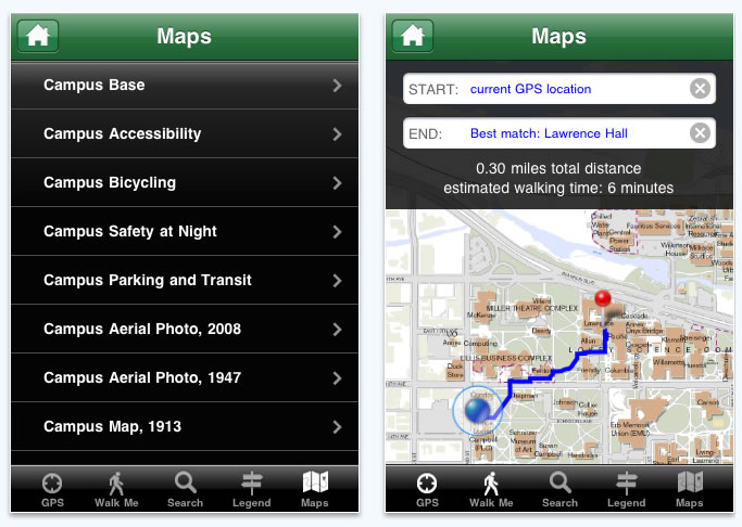
UOregon iPhone app users can select from a list of multiple map views of the campus (left). Tapping the "Walk Me" icon on the bottom of the screen provides From and To fields for sidewalk routing.
That project's success enabled the lab's team to respond to the request of Richard Lariviere, the university's then-new president, to develop an app specifically for the university. "The president and his communications team wanted to pursue an iPhone app that located events, such as baseball games and rallies, as well as other campus-related information," said Ken Kato, assistant director of the InfoGraphics Lab.
"Because the lab built and maintained the campus GIS databases and had experience with the ArcGIS API for iOS, we knew we could deliver an app to serve the campus, especially incoming freshmen, for whom the campus is an entirely new environment."
Moving beyond Basic Mapping
The team members' experience using Esri's web mapping APIs and beta iOS software developer kit (SDK) helped them build the initial iPhone prototype app in just a couple weeks. This was a unique feat, given the functionality of the application. The team wanted to go beyond adding geocoding points on Apple's Map Kit or Google Maps and instead create something that could accommodate fast-rendering, high-resolution maps and the room-level GIS data the lab maintains. To do this without outside vendor help, the lab's staff members pulled from all the resources in the ArcGIS for iOS SDK and Esri desktop software as well as their own data.
"We asked ourselves, 'Why don't we use our own custom maps rather than Microsoft's or Google's?'" said Dana Maher, lead programmer and a graduate student. "We have high-quality cartography that's maintained to be current and accurate on a daily basis, and we wanted to put it to use."
A data collection that spanned decades, including aerial photos of the campus from 1913 and 1948, had been digitized and was ready to be served from the geodatabase. Team members knew that Esri's ArcGIS Server would allow them to add their own custom cartography as basemaps in their viewers. "We liked the idea that we could serve those maps out as a tiled image cache," said Maher. "This meant only the necessary image tiles [the ones being viewed] dropped instantly into place as users zoomed and panned."
Working at the lab are staff and students from the Geography Department who are passionate about geospatial technology and eager to show off what they can do. As such, showcasing the whizbang element of today's geographic server technology was a major objective during the project. "We wanted to demonstrate the depth of the mapping available with Apple and Esri technology," Kato said. "The sentiment at our meetings was that our research applications have really matured and it'd be great if we could mirror some of that functionality on the iPhone app."

An "Events" feature lists upcoming campus events, listed by category. Tapping each event takes users to a detailed description of the event.
The Find Maps function in the latest ArcGIS API for iOS struck Kato as particularly well-suited for allowing users to choose the basemap they wanted. "I thought that was perfect for us to incorporate a similar function because we have many cartographic visualizations of the campus that we already maintain for our web application," he said. "The 1917 basemap shows [that] the room we're in was in the end zone of our old football stadium. In 1948, the campus had undergone some major changes but still looked very different [from now]. We included two old basemaps, a map from 1913 and an aerial photograph from 1948, because we wanted students to experience the various temporal views of the university grounds." In addition to those vintage basemaps, the app includes the following maps: Bicycling (which shows all the campus bicycle lanes), Safety at Night (which plots the safest routes for nighttime walking), and Accessibility (which shows the location of wheelchair ramp entrances).
Week of Welcome
The free app plays a major role in the university's Week of Welcome, the official orientation period for incoming freshman students. Finding dorms, bookstores, registration events, and classrooms can be tricky during this time, so the lab team made a point to include a directions feature in the interface. The app uses the onboard iPhone GPS to show where the user is on campus to provide sidewalk-level routing. This Walk Me feature takes users to any campus events that are being fed to the app and also can be used to display a route with start and end points anywhere on campus, including an estimated walking time. "We wanted to give it a routing feature," said Jacob Bartruff, GIS analyst and programmer. "We knew that new students, unfamiliar with the campus, would find sidewalk routing invaluable."
"This was one of the more interesting parts about putting the project together," said Maher. "It was fun to figure out how to extend the iOS SDK to do point-to-point routing. I don't really know of any other university that creates custom campus- and sidewalk-level mobile routing networks."
University of Oregon's mobile mapping technology also helps students locate their classes; access campus security in the event of an emergency; find where campus activities, such as art shows and ballgames, are happening; and keep up with social media. App users can also stay up to date on University of Oregon news and events and view the 295-acre campus with a continuously updated feed of photos and videos. The lab also injected some school spirit into the app by including the institution's fight song, "Mighty Oregon," played by the university's marching band.
With more than 8,000 students and faculty members currently using the UOregon iPhone app, as well as positive feedback and very favorable ratings in the Apple App Store, it likely won't be long before other colleges and universities integrate mobile GIS mapping capabilities to create an immediate, on-the-go experience that is always available for students right at their fingertips.