ArcWatch: Your e-Magazine for GIS News, Views, and Insights
February 2011
Looking Forward: Five Thoughts on the Future of GIS
Any attempt to forecast the future is dangerous, and attempts to prophesy about GIS are especially fraught, so what follows should be taken with a large grain of salt. But it is good to think about where we—the GIS community—might be headed, and perhaps this short contribution will stimulate other members of the community to ponder and discuss the possibilities.
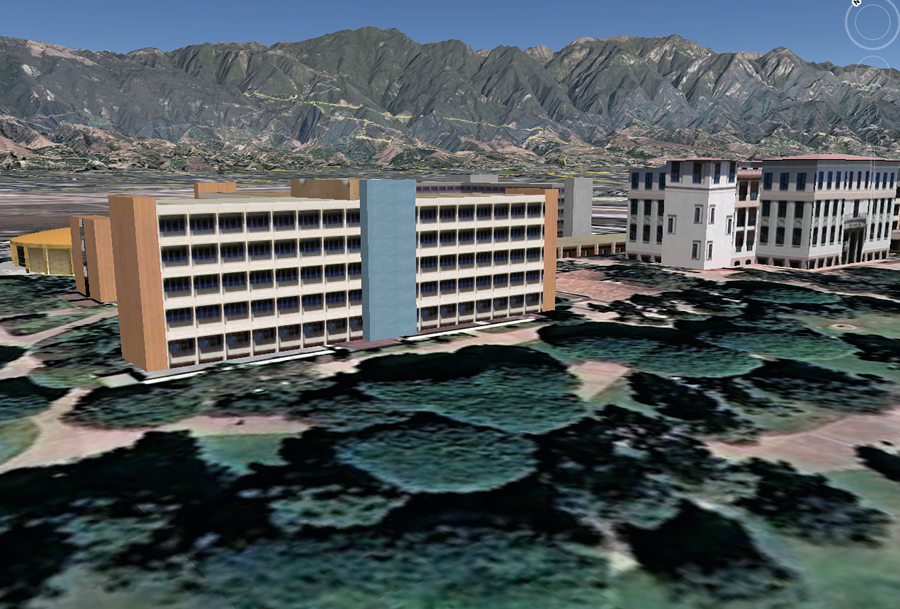
A visualization of part of the University of California, Santa Barbara, campus shows 3D representations of buildings superimposed on a more traditional 2D GIS representation of the ground surface. (Image courtesy of Keith Clarke)
The 13 Percent Technology
The GIS domain has always been the outdoors, where GPS signals are strong and reliable, two spatial dimensions are generally adequate, and spatial resolutions are rarely better than a meter. Not surprisingly, the earliest applications of GIS were in forestry, resource management, and land-use planning. But the average American only spends 13 percent of the time outdoors. GIS-based services help us find restaurants and hotels, but they offer almost no support for navigating in the complex indoor spaces of shopping centers, hospitals, mines, or airports.
Two major problems currently stand in the way of moving GIS indoors. Several years ago, I was involved in a study sponsored by Defense Advanced Research Projects Agency (DARPA) to examine the potential of a fully three-dimensional GIS. There are several billion buildings on the planet, and we estimated that a database representing all of them, surface and interior (CityGML Level of Detail 3 and above), would occupy 3 petabytes (3,000 terabytes or 3,000,000 gigabytes), a not-unmanageable volume given today's technology. But the effort to assemble such a database using then-available technology would require an expenditure equivalent to 10 percent of the U.S. gross domestic product (GDP) for 10 years—in other words, it would need to employ 10 percent of the U.S. workforce for that period. And that figure would not include updates. We need techniques for the rapid, cheap, and accurate capture of 3D geometries and attributes.
Furthermore, we need effective methods for determining indoor position. Several technologies are under development: Wi-Fi, using known positions of transmitters; radio-frequency identification (RFID), using networks of fixed detectors; ultrasound or laser imaging matched to 3D geometry; and many more. At this point, we don't know which of these—if any—will eventually succeed. However, we do know that the market for solutions to the problem of moving GIS indoors—and integrating the indoors and outdoors—holds enormous potential.
Knowing Where Everything Is
I can now express the location of my house in half a dozen ways, ranging from the National Grid reference 11SKU3614611561 to "Mike Goodchild's House," and expect Web services to make sense of all of them. Anything from the formal coordinates of GIS to the informal, everyday language of humans (street addresses, named points of interest, place-names) is now readily understood. This level of interoperability between different ways of specifying location is, in my view, one of the great geospatial achievements of the past decade. With GPS, RFID, and up-to-date databases, we can now imagine a time when it will be possible to know where everything is at all times. This is already true over surprisingly large domains: every vehicle in some major fleets, every farm animal in some countries, every commercial flight, every mobile phone, and every credit or debit card when it is swiped.
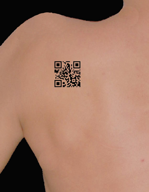
A QR code tattooed on a human back is readable by a smartphone app. (Image courtesy of Karen Doehner)
While there are obvious benefits in each of these cases, the possibility of knowing where every person is at all times is far more problematic. While a mobile phone user only has to turn the phone off, face-recognition software, coupled with the dense networks of video cameras now installed in many major cities, make it possible to track individuals without their knowledge and offer no way to opt out that is not itself grounds for suspicion. Yet consider the possibilities during emergencies: if every inhabitant of the Wenchuan area of China had been tracked prior to the May 2008 earthquake, it would have been much easier to search for possible victims.
An Internet of Things
Knowing where everything is, and where it has been, creates a host of interesting possibilities that is currently being explored by the Tales of Things project in the United Kingdom. All that is required is a Quick Response (QR) code (one of those random-looking square patterns of black and white that now appears on packages, airline boarding passes, and mail) attached to the object. When this pattern is scanned by a smartphone with the appropriate app, an online database of the object's history is accessed, and the object's current location is captured along with any other useful information. The result is a readily accessible geographic history of the object. Of course, QR technology is already widely used, but the smartphone enables many new and interesting applications. Imagine the possibilities of a QR tattoo.
Real-Time GIS
Maps take time to make, and to justify the cost of making them, it is important that they be valid for as long as possible. Traditionally, this has meant that maps are made up only of the more permanent features of the earth's surface: roads, rivers, mountains, and streets. Over the past two decades, however, the widespread availability of GPS and mapping software has changed the balance in this equation, making it possible to create maps of virtually anything for almost nothing. Neogeography is one result: the possibility of making personal maps, showing personal views that may be of interest only to the maker and for just a brief time. A GPS navigation system, fed by sensors, might show the state of congestion of the road system in real time; an air-traffic controller might see a real-time map of airplane traffic; an emergency manager might view the real-time situation of disaster response; and a public health researcher might monitor the real-time state of a disease outbreak.
All these possibilities and more are shifting GIS from the relatively leisurely process of analyzing static data to a far more dynamic process of real-time monitoring and decision making. In the future, GIS will involve much more real-time situation monitoring and assessment and will need new kinds of tools that treat information as continually changing. Decisions will have to be made on the basis of information available at the time and deal with uncertainties about the future in rational ways.
Multiple Views of the World
In the early 1990s, GIS came in for plenty of criticism from social scientists for its implied assumption that all aspects of the world could be measured and represented scientifically—that geographic truth was absolute rather than personal and relative. Too often GIS presented a single point of view, often that of government, rather than the multiple points of view of individuals and groups. Recently there have been several international incidents involving Google's maps and its portrayal of disputed boundaries and place-names, as reported in an article in Maclean's, a Canadian weekly current-affairs magazine. In the Himalayas, for example, the view presented by google.com is now sharply different from those presented to Indian users via google.in or to Chinese users via google.cn. In both countries, the law requires that maps displayed by local servers reflect official national policy. Thus, google.in shows Kashmir as part of India, whereas google.com shows it as disputed between India and Pakistan.
Maps reflect the agendas and beliefs of their makers, a point that sits uncomfortably with the prevailing scientific approach of GIS. In principle, the name given to a place is not absolute but is an attribute of the individual or group giving the name. To the English, the body of water separating England from France is the English Channel, whereas to the French it is La Manche. Will multiple views be manageable, or will GIS descend into a chaos of conflicting perspectives?
Multiple Futures for GIS
I hope these brief comments have stimulated an interest in discussing these five topics further. Are they equally important, and are there other ways in which the GIS of the future will be different from that of today? One fact is inescapable: the world of GIS has always been full of surprises, and there is every reason to believe the future will be just as exciting.
Michael F. Goodchild welcomes feedback on this topic. Contact him at good@geog.ucsb.edu.