ArcWatch: GIS News, Views, and Insights
February 2012
Geodesign Gathers Momentum
Two-Day GeoDesign Summit Focuses on Geodesign Technologies and Practices
The term geodesign, once hard to define, is becoming part of the vernacular in the design field. That astute observation opened this year's GeoDesign Summit, a gathering of professionals interested in using geospatial technologies to arrive at the best and most sustainable design solutions.
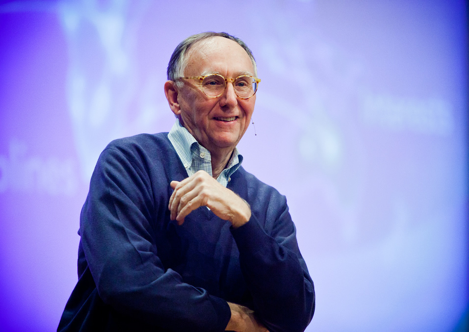
Esri president Jack Dangermond welcomed 200 people to the GeoDesign Summit in Redlands, California.
"An (online) search for the term geodesign peaked at 85,000 [mentions] on the web in 2011," said Shannon McElvaney, project manager for GeoDesign Services at Esri and the master of ceremonies for this year's GeoDesign Summit, held January 5-6, 2012 in Redlands, California. "That's a meteoric rise in the last three years. For this and a number of other reasons, which I think you will see in the next two days, I firmly believe that geodesign as a concept is here to stay."
The theme of the summit, Geodesign in Practice, went to the heart of geodesign's ultimate goal: finding innovative solutions to the most pressing challenges by fusing design processes with geospatial technologies. In other words, geospatial technologies will provide the analytic capabilities necessary to evaluate different options and the tools to collaborate as these alternatives are weighed.
"This is not just the classic design field," Esri president Jack Dangermond said during a talk that welcomed to the summit geodesign practitioners from a diverse range of fields and industries including urban planning, architecture, transportation, utilities, and telecommunications. "This mixing of science and design goes right across all of society."
Dangermond underscored the importance of putting geodesign to work on pressing issues such as climate change, energy needs, health, poverty, and biodiversity loss. In hearing former US president Bill Clinton speak at the recent Eye on Earth Summit, Dangermond said that he was struck by Clinton's words about taking action. "He talked about all the policies and discussion about climate change and population, and he said, 'I'm not really sure all these discussions are going to matter.' There was silence in the room. He said, 'What I actually have faith in are real projects. I'm dedicating my life to doing projects in [places like] Africa, Latin America, and India.' He said where the rubber hits the road is doing real project work. Isn't that really what geodesign is about?"
Geospatial Systems Essential to Understanding
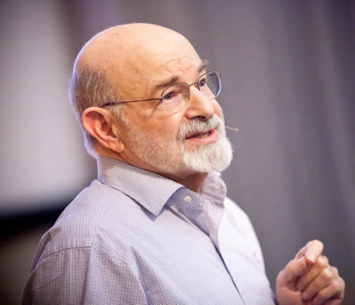
Carl Steinitz wrote A Framework for Geodesign, which Esri Press will publish this summer.
Geospatial systems are critical to understanding the problems society and organizations face, according to Dangermond. "They are converting data into maps [or] information," he said." They are integrating mapped datasets through map overlays and integration and modeling to create knowledge of how things are working. One of the great contributions that the web is making is the collaborative sharing environments that are allowing us to bring our knowledge together over the web to create better understanding. These trends are half of the story. The thing we need to do is link all that information/knowledge with the design process [using] tools and methods that allow us to create sustainable designs and environments in the future."
Geodesign Framework and Technologies
At this year's summit, the conversation among the 200 attendees focused on the emerging technologies for geodesign, geodesign in education, and geodesign case studies. Highlights included
- Technological advances that support geodesign, including demonstrations of new sketching, design, and scenario management tools in ArcGIS 10, along with Esri CityEngine generation of 3D content, such as buildings, trees, and roads, from GIS data.
- How elements of geodesign are being put into practice by urban planners, architects, landscape architects, design and GIS professionals, and even marine scientists. Speakers delivered a wide range of Lightning Talks, including Red Fields to Green Fields—Los Angeles, a project where geodesign was used as part of the process to create a plan to transform rundown, vacant land into parks and green, open space.
- The growing number of higher education institutions that are launching geodesign programs or curriculums. These include Penn State University, which is developing a master's program in geodesign, and Northern Arizona University, which has already launched a bachelor's degree in geographic science and community planning.
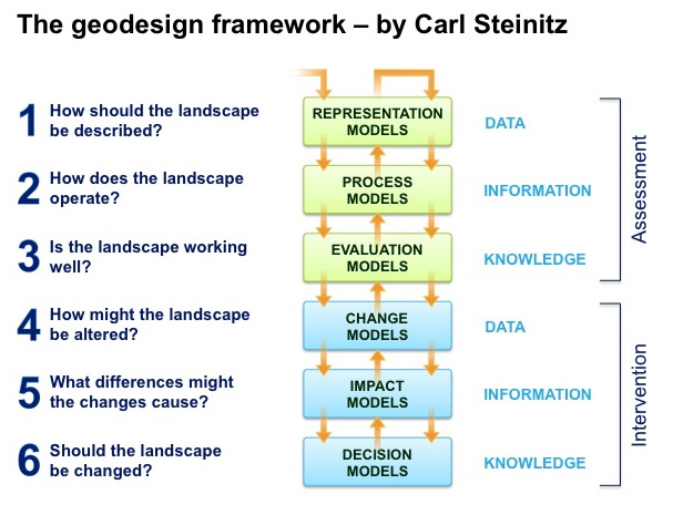
The geodesign framework conceived by Carl Steinitz of Harvard University.
Speaking at this year's conference was Carl Steinitz, Alexander and Victoria Wiley Professor of Landscape Architecture and Planning Emeritus, Graduate School of Design, Harvard University. He just finished writing the book A Framework for Geodesign, which will be published by Esri Press this summer. Bill Miller, the director of GeoDesign Services at Esri, wrote a working paper in which he says that the book will likely become an important resource for geodesign practitioners and academics.
This complete framework includes
- Representation models: How should the landscape be described?
- Process models: How does the landscape operate?
- Evaluation models: Is the landscape working well?
- Change models: How might the landscape be altered?
- Impact models: What differences might the changes cause?
- Decision models: Should the landscape be changed?
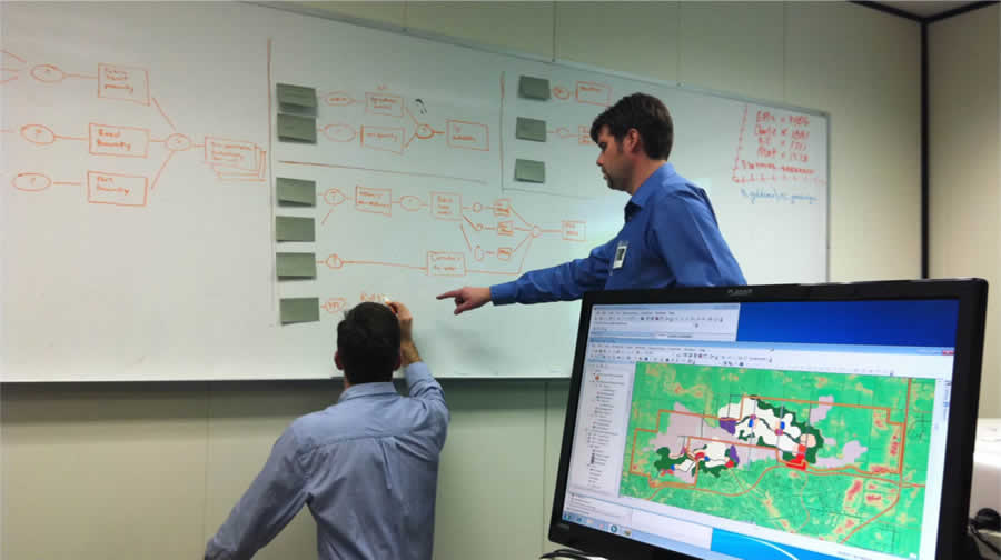
Christian Goss and Bill Souter from O2 Planning + Design discuss changes to their suitability and sensitivity models.
"In Carl's book, that's forthcoming, we now begin to realize that geodesign is not just a concept," said Dangermond. "It can be thought of as a systematic process of measuring and modeling and interpreting and designing and evaluating and making decisions. And articulating that well and embedding that into the workflows of how we create the future is the real plot of discussion here."
Years from now, Dangermond said, people will look back at geodesign as "an evolutionary step for humans. It's going to be, 'Ah, finally we connected the dots. Finally we began to realize the implications or the consequences of our actions.'"
During the summit, product engineer Matthew Baker from the Software Development team and solutions engineer Eric Wittner from GeoDesign Services at Esri demonstrated some work the company is doing to develop GIS software that supports geodesign. Steinitz's geodesign framework remains the key model for the workflows and tools developed by Esri to support geodesign with ArcGIS, Baker said. "We know that geodesign is software independent, so our challenge is, how does our software fit in with this framework?" he asked.
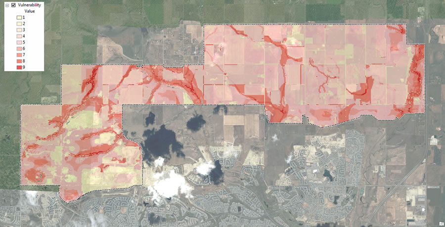
A Layer Depicting Vulnerable Areas That Development Should Avoid, Based on Spatial Analysis
With the framework from Steinitz in mind, tool development efforts focused on studying the workflows of several design firms that have geodesign projects in the works. One such firm is O2 Planning + Design, based in Calgary, Alberta, which is working on a transit-oriented development north of the city.
Geodesign workflows involve creating suitability and sensitivity layers that will inform design, such as this layer to the right that depicts the vulnerable habitats in the proposed development study area.
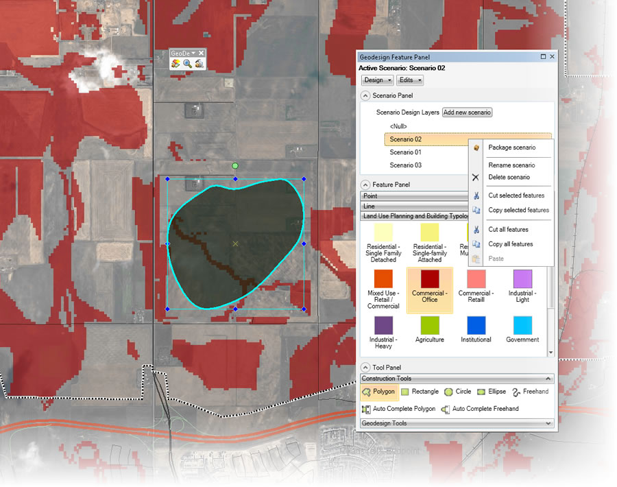
A New Tool for Creating, Managing, and Populating Scenarios in ArcGIS
After studying the workflows of several other design firms, Esri developed a set of tools that would facilitate sketching and design. This new geodesign window for ArcMap, which will be in the upcoming ArcGIS 10.1 release, lets people easily search for and download design templates from ArcGIS Online that include tools for creating, manipulating, and interacting with a design.
The window also brings together several core tools into one centralized window, with easy access to the tools that facilitate sketching and design.
One key aspect of the window is scenario management. The ability to create and manage multiple scenarios is something that has not previously existed in a GIS. With the design in place, said Baker, the next step is to visualize what a design might look like if built.
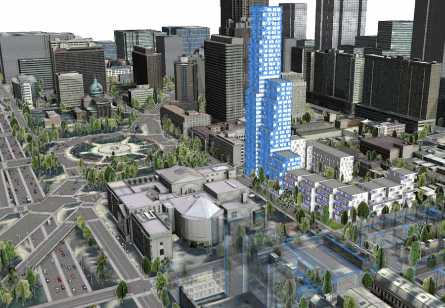
Esri CityEngine technology created this rendering of what a fictional development would look like in the City of Philadelphia, demonstrating the power of rule-based 3D modeling.
This can be done with Esri CityEngine software. CityEngine allows an urban form to be rapidly created on top of GIS data by procedurally creating features such as streets, parcels, blocks, buildings, houses, open spaces, and vegetation based on sets of rules. In the case of O2 Planning + Design, the rules looked at the underlying data to visualize the density and arrangement of buildings as described in the foundational land-use and intensity plans.
High-intensity areas, with mixed-use zoning, drove denser street network creation, smaller lot sizes, with taller buildings. Likewise, residential zoning in low-intensity areas automatically creates less dense streets, larger lot sizes, and houses rather than multistory buildings. The buildings and houses can be rendered as simple massing models; color coded by zoning type; or developed into geometrically complex, fully textured buildings with step backs, balconies, windows, and terraces.
Wittner demonstrated how spatial analysis inside Esri's 3D City template can be used to drive site analysis and selection; CityEngine is then used to do advanced plan visualization, and the results are pulled back into the template for use in analysis. CityEngine, when paired with ArcGIS, provides a powerful tool for understanding and visualizing what could be, in the context of what is.
Geodesign in Action
Besides watching technology demonstrations, which included a presentation about ArcGIS Online, the audience also heard talks from more than a dozen professionals who incorporate geodesign in their work.

One of O2 Planning + Design's Sketched Land-Use Scenarios for the Nose Creek Watershed in Alberta
They included Stuart Rich from PenBay Solutions LLC, who spoke about how geodesign is helping Kuwait University plan construction of a new, multibillion-dollar campus; Lilian Pintea from the Jane Goodall Institute, who described how geodesign is being used to protect chimpanzees through community-centered conservation; and Abby Jones from the Anthro/Ecological Design Collective, who talked about the role of geodesign in a project to turn distressed land into parks in Los Angeles.
Jones spoke about geodesign at a small scale—a neighborhood park or community garden, for example.
Keynote speaker Braden Allenby stressed the importance of thinking about geodesign at a greater, global scale to deal with complex issues such as climate change, water resources, biodiversity, and the economy. Allenby, Lincoln Professor of Engineering and Ethics and professor of civil and environmental engineering at Arizona State University, also talked about designing for complex adaptive systems such as the Florida Everglades. "You never go backwards in a complex adaptive system. You may go to someplace new, but you are not going to get the world that you had. You want to restore the Everglades? It will never happen," he said. "What you will get is something that is new and maybe pristine and maybe very biodiverse, but you will not get the old Everglades back. . . . What we need to do is learn how to design in the context of complex adaptive systems."
The audience at the GeoDesign Summit heard from more than 30 speakers.
Will McClintock, a marine scientist from the Marine Science Institute at the University of California, Santa Barbara, gave a presentation called SeaSketch: Designing for our Oceans. Using Esri technology and the JavaScript API, his lab is currently developing the SeaSketch application that will let anyone log on to a website and sketch out proposed marine protected areas in the ocean. The application, scheduled to be available this summer, will provide automated feedback on how well the designs meet science and policy guidelines such as those targeted at protecting ecosystems and minimizing economic impacts to fisheries.
McClintock called SeaSketch the next generation of the MarineMap application, which in the past let stakeholders draw networks of proposed marine protected areas off California's coast and then assess their designs according to scientific guidelines and economic and social impacts.
"We really have reached the point in history where the tools required for sound decision making about how we use ocean resources are no longer restricted to people with specialized knowledge," said McClintock. "You can do this. Everybody can do this. Everybody should have the ability to express their opinions about how ocean space is used and measure those opinions against good science."
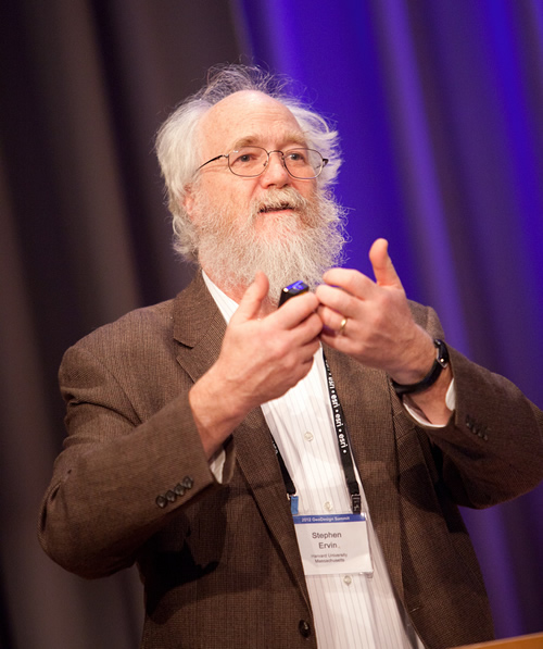
Stephen Ervin of Harvard University pondered the future of geodesign.
The GeoDesign Summit ended with a thought-provoking talk on the future of geodesign by Stephen Ervin, assistant dean for information technology at the Harvard University Graduate School of Design and a lecturer in the department of landscape architecture. He looked ahead to what's possible, probable, certain, likely, unlikely, and inevitable in a world with geodesign.
While Ervin said he thinks that it's highly unlikely any agreed-upon definition of geodesign will ever emerge, one certainty will be a planet of 10 billion people. "It is for these people that we do geodesign," he said. "It's not for the trees or the hydrological systems or the atmosphere. It's for the 10 billion people that are our inheritors of what we do."
The next GeoDesign Summit will be held January 24-25, 2013, at Esri in Redlands. For more information, visit geodesignsummit.com.