ArcWatch: GIS News, Views, and Insights
February 2012
GIS Day 2011 Filled with Discoveries for People around the World
Thousands of people in more than 60 countries took the 2011 GIS Day theme of Discovering Our World through GIS to heart: They devoted hours to learning how geospatial technology solves practical problems and answers important questions about the world around us.
In Birmingham, United Kingdom, students celebrated GIS Day by learning how retailers such as supermarkets use GIS to decide where to locate their stores.

The Republic of Panama celebrates GIS Day.
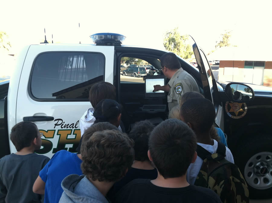
In Pinal County, Arizona, government employees showed how they use GIS to keep track of what is happening during emergencies, including using digital maps accessible via a mobile viewer mounted inside the cab of a sheriff's department vehicle.
In Roseau, Dominica, in the West Indies, staff from the government's Land and Surveys Division demonstrated how they used ArcGIS to create a tsunami evacuation route and a tourist attractions map.
"Both [presentations] showed the different ways GIS can be useful, both for development and safety," said Kendell Barrie, a GIS/geovisualization specialist for the division.
GIS Day 2011 was officially celebrated on November 16; events are held annually on the Wednesday during the National Geographic Society's Geography Week. Sixty-nine countries and 48 US states registered events in 2011.
Since 1999, GIS Day has served as a global grassroots celebration of geospatial awareness and technology, with sponsors such as public agencies, schools, and industries organizing events to promote GIS and geospatial literacy among adults and youth.
"It is important to introduce our students to this type of technology at a very young age," said Loretta Garcia-Palacio, managing director of Total Business Solutions Ltd. (TBSL), Esri's distributor in Belize, which hosted its first GIS Day Expo in 2011. "GIS is a new way of spatial literacy for Belize. The world is going through a geospatial revolution—everybody is now pointing to a map. And we don't want our students to be left behind."
Elsewhere, people celebrated GIS Day by visiting map galleries and attending seminars, demonstrations, hands-on workshops, open houses, and parties to learn about the power and potential of geospatial thinking. They also participated in community expos, school-wide assemblies, mapping projects, geography games, and GPS scavenger hunts. For example:
- The water utilities department in Oceanside, California, hosted a map/poster gallery that included the city's emergency evacuation and watershed maps.
- At the Sawnee Emergency Management Center in Cumming, Georgia, GIS Day attendees viewed maps created by GIS professionals including one that showed where squirrels caused power outages.
- Historical examples of geographic analysis, such as the map created by Dr. John Snow that helped him analyze the cholera outbreak in London in 1854, captivated Frontenac County council members in Glenburnie, Canada.
- Primary school- to college-age students in Brno, Czech Republic, viewed a thematic maps showcase, searched for a hidden geocache, and attended flight simulator workshops.
Students in Pinal County, Arizona, learn about how GIS is used during emergencies.
Careers in GIS
For its first celebration, the US Department of the Interior's Bureau of Land Management (BLM) field office in Butte, Montana, adopted an educational approach. BLM volunteers focused on getting the students interested in GIS technology, which plays an integral role in managing the area—from its forests to its cultural anthropology—across more than 300,000 acres.
"Allowing students to jump right into ArcGIS has proven very educational for them," said Bradlee Matthews, GIS specialist for the Butte field office. "Their creativity really shines."
BLM specialists showed students a short presentation on how the field office uses GIS for natural resource management and analysis and educated them about the benefits of pursuing a GIS career. The hosts gave the students the opportunity to work with Esri's ArcPad software and GPS units.
Solving Real-World Problems
To fire up young imaginations and demonstrate how GIS can be used on the road, Pinal County, Arizona's GIS Day event featured a look at how a county command and communication vehicle and a Pinal County Sheriff's cruiser use the technology. County workers who visited the Florence K-8 School also introduced more than 250 students to the county's public GIS website and provided tutorials on tools and functions for querying information. Representatives from the Town of Florence showed how GIS and GPS can be used to help maintain utility data and emergency hydrant locations.
More than 500 people attended the GIS Day celebration at the Washington State Department of Transportation (DOT) in Olympia for a hands-on workshop, seminar, and map competition. The winner of the People's Choice award in the map competition was a map of the Monastery Complex Fire. That wildfire destroyed at least 29 homes and burned more than 5,000 acres of brush and trees northeast of Goldendale, Washington, last September. The Monastery Complex Fire map was originally produced for the Washington State DOT Emergency Operations Center to aid in response efforts during the disaster. It showed which portions of US Highway 97 were impacted by the wildfire.
Boundless International Enthusiasm
Cost is often perceived as a hindrance in utilizing GIS technology. However, high school and college students in Maasin City, Southern Leyte, Philippines, learned that this no longer is true during GIS Day presentations that highlighted the uses and mapping applications of low-cost GIS tools. This year's local theme—GIS for Effective Planning—focused on intensifying awareness of environmental concerns and promoting disaster prevention and preparedness to complement the province's economic advancement. Participants discovered that GIS now can hasten the planning processes of various agencies.
In Dyssegård, Denmark, 52 students aged 12 through 14 registered more than 140 incidents of graffiti in their community using GPS units and then analyzed the results via maps on ArcGIS Online. They started the day with a short introduction to GIS, including how and why geography matters both in and outside the classroom. Then the students took to the streets with maps that showed what area they had to cover.
First, they selected whether a piece of graffiti was a tag (like a signature), a piece (larger picture/painting), or a mix of both, then documented it with a picture, wrote in any comments—was it nice or ugly; was it on a utility control cabinet, lamppost, and so on—and finally selected the position.
"A project like this primarily involves geography, but the students also learn how to handle IT," said geography teacher David Agerbaek Jeppesen. "And by working on this, they also play an active part in society. They learn more about being a good citizen and might end up helping the municipality save some money by giving them the knowledge of where the graffiti is exactly."
In Ghana, the University of Mines and Technology hosted an educational open house for GIS Day. Sponsored by the Geomatic Engineering Students Association and Esri distributor SAMBUS Company Ltd., the event drew geomatic engineering students and members of the general public. A PowerPoint presentation showed how GIS is used in the local mining industry. The attendees also viewed a display of paper maps created using GIS, listened to a talk about the benefits of geospatial technology, and took part in a geocaching event with handheld GPS devices.
"Promoting geographic intelligence is quite necessary with the increasing amount of geospatial career opportunities in the work force," said Mousah Iddirisu Abu, GIS Day event coordinator in Tarkwa, Ghana. "As twenty-first-century engineering students, we must know the importance of keeping up with technology and gaining new skills. This will enable us to see the trends and patterns in understanding geographic problems or world needs and provide solutions to them."