What's In a Name? Everglades Conservation Plan Uses GIS to Define Place Names
By Matt Freeman, Esri Writer
 The Comprehensive Everglades Restoration Plan (CERP) is the largest ecological restoration project in the world. Headed by the South Florida Water Management District and the U.S. Army Corps of Engineers, CERP uses a GIS-based gazetteer to serve as an authority on its 80 project place-names and their spatial footprints. |
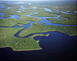
Contrary to popular belief, the Florida Everglades is not merely a giant swamp of tall grass where alligators and water snakes lurk. It is a subtropical wetland ecosystem where thousands of species of plants, birds, mammals, fish, and reptiles depend on its natural wet and dry weather cycles.
But with agriculture and industry flourishing and urbanization encroaching on the Everglades, the native habitat must compete with businesses and new residents for the same water source. Over time, people have manipulated the water supply by constructing dams, water treatment plants, canals, and floodgates. The growth of native vegetation has been interrupted by water runoff from farms that has introduced excess nitrates and phosphates. These types of activities have altered the Everglades' natural water patterns, leaving behind a lengthy list of plants and animals on the endangered species list.
To help restore the habitat, the South Florida Water Management District (SFWMD) and the U.S. Army Corps of Engineers (USACE), along with many partners, have launched a unique environmental effort known as the Comprehensive Everglades Restoration Plan (CERP). The program is a long-term, multibillion dollar initiative aimed at restoring natural systems throughout the Everglades through 80 engineering and construction projects. CERP's goal is to capture fresh water that flows unused to the ocean and gulf and redirect it to areas that need it. Most of the water is devoted to reviving the Everglades' dying ecosystem, while the remainder benefits cities and farmers. To keep everyone involved in the restoration plan informed and updated about the accurate place-names inside the 18,000-square-mile restoration plan area, CERP needed a GIS-based gazetteer to serve as an authority on project place-names and their spatial footprints.
Traditionally, gazetteers exist in paper form and catalog geographic information such as places, place-names, place boundaries, and the social and geographic statistics related to each place. Modern gazetteers are kept in a digital format, which is why CERP contracted with Photo Science, a Florida-based geospatial solutions company, to develop the South Florida Gazetteer.
Communication Clearer with Gazetteer
 CERP stakeholders can access and query project data stored in the gazetteer from an ArcGIS interface in CERPZone, CERP's information technology Intranet system. |
The South Florida Gazetteer was created to provide CERP project managers and stakeholders with a tool to reference and store geographic data related to CERP project areas. The gazetteer's standardized spatial and naming attributes also promote clear communication between the many government agencies and private contractors involved in the multifaceted effort. All CERP stakeholders have access to the data stored in the gazetteer through CERPZone, the project's information technology (IT) intranet system.
According to CERP GIS data coordinator Heather Kostura, confusion over the Everglades' place-names and spatial footprints is not uncommon. "Some project managers have worked in the Everglades for a very long time, and some places are known by more than one name," she said. "Capturing a place-name and storing it in a gazetteer is important because the names of places change over time; a project manager who has been in the area for 50 years still may know a place by the name 'Joe's Farm' when someone else knows it by a different name. By giving a place an official place-name and documenting it in the gazetteer, it helps avoid confusion and redundancies within CERP."
Esri's suite of ArcGIS products, such as ArcView and ArcIMS, are used extensively in CERPZone and within SFWMD and USACE. In addition, many agencies in Florida use Esri software or can produce spatial data layers in a format suitable for ingestion into an Esri geodatabase. Because of Esri software's commonality, the gazetteer project team designed the South Florida Gazetteer database to operate within CERPZone's ArcGIS Desktop environment. The GIS infrastructure of the gazetteer provides visual representations and sharing of project data and helps maintain workflows and prevent boundary conflicts between SFWMD, USACE, and various other agencies and partners involved in CERP.
Adding the Place-Names
Place-name, attribute, and project boundary data finds its way into the gazetteer via a custom-built Data Loading Application and Data Automation Application. The Data Loading Application operates through an ArcSDE geodatabase with a Microsoft Visual Basic for Applications (VBA) code written within a Map Document File (MXD).
 The GIS infrastructure of the South Florida Gazetteer provides visual representation and sharing of project data. It also helps to maintain workflows and prevent boundary conflict between stakeholders and various other agencies involved in CERP. |
When entering data in the Data Loading Application, project stakeholders are guided through a wizard-style process that consists of a series of prompts related to data attributes. Once the manual process is completed, data is uploaded to the gazetteer, then accessed through CERPZone. In contrast, the Data Automation Application updates the gazetteer automatically on a nightly basis. It operates within CERPZone's IT scheduling environment and relies on ArcObjects to check the GIS systems of SFWMD and USACE for updates to feature classes, then populates the gazetteer. Although the gazetteer is completely populated with the data that is specific to CERP projects, the Data Automation Application uploads additional data relating to project areas as it becomes available from SFWMD and USACE.
The public can also access official place-names stored in the gazetteer by visiting the Projects tab of the Web-based CERP GIS Project Locator at www.evergladesplan.org. Through a GIS toolbar and query function, the Project Locator provides users with the ability to locate projects, retrieve project information, print custom-made maps, and view project boundaries. Those with access to desktop GIS can also extract and view metadata from the GIS Project Locator.
Since CERP is a federally funded project, the project team modeled its gazetteer place-names after the place-type standards set by the United States Geological Survey (USGS) for the Geographic Names Information System (GNIS). GNIS is the official vehicle for geographic names and is used by the federal government as a source for applying names to federal maps and the National Map, a GIS-supported online interactive map service. A future CERP goal is to populate the South Florida Gazetteer with enough data that it will be considered for submission in GNIS.
Kostura admits that the goal is lofty and somewhat disparate, since some of USGS' place-type standards have no relevance to CERP projects. "Our gazetteer is lacking some simple USGS place-type populations, like cemeteries, which we haven't populated yet because it's a place-type that doesn't relate to CERP," says Kostura. "We may grow old working on this, but we're not too worried about those cemeteries just yet."
For more information about CERP, visit www.evergladesplan.org.