Enterprise GIS Helps Safeguard the Qinghai-Tibet Railway
By Susan Harp, Esri Writer
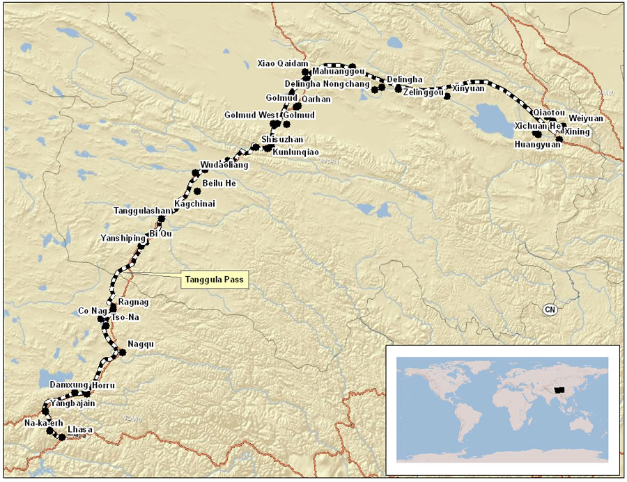 This map shows the route of the Qinghai-Tibet Railway from Xining to Lhasa. |
At festival's end, tired pilgrims attending the Sunning of the Buddha Festival in the Chinese city of Xining—the capital of Qinghai Province—board the Qinghai-Tibet Railway train and start the 26-hour trip home to Lhasa, capital of Tibet Province. Whether occupying seats or sleeper berths, they can rest assured that their overnight trip will be a safe one, thanks to the railway's high-tech control center that uses geographic information system (GIS) technology to display real-time monitoring of the train's location and speed, oxygen levels, and electrical system.
The Qinghai-Tibet Railway Bureau and the State Key Laboratory of Rail Traffic Control and Safety at Beijing Jiaotong University collaborated to design the control center. The organizations decided to use GIS technology to manage and display the spatial data needed to keep the train running safely and efficiently.
The resulting system, the Comprehensive Monitoring System of Railway Operation and Safety for the Tibetan Line, displays maps, including 3D versions, to track the train's location, check the real-time weather conditions along the route, and monitor the status of conditions such as the temperature inside passenger cars.
The train needs such close monitoring because it will climb from Xining, at an elevation of 2,275 meters (7,463 feet), to cross the "roof of the world," a remote Himalayan plateau at an altitude of 4,000 meters (13,124 feet), before it reaches its destination more than 1,900 kilometers (1,180 miles) away. High altitude reduces oxygen levels for passengers, and the remote location makes it essential for managers to know when and where a train stops in case they need to stage a rescue.
Control Center Counts on Esri Technology
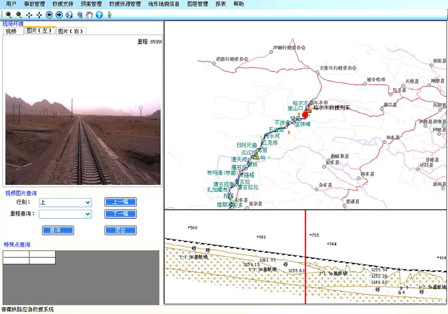 The information query page for the Qinghai-Tibet Railway emergency response and recovery system displays georeferenced images and topography of the track route. |
During construction of the railway, which cost US$4.2 billion, the project's planning engineers decided to design a control center that would receive and display data from the variety of monitoring devices on the train and along the track and combine them with data from the railway's Microsoft and Oracle databases.
They also needed to display photographs and satellite images of the landscape surrounding the tracks to support the emergency response planning and rescue system—to identify helicopter landing sites, for example.
The control system needed to help keep railway downtime to a minimum, monitor equipment, minimize maintenance needs, and provide a detailed record of environmental conditions along the track.
Esri China (Beijing) Limited, a project consultant and Esri's distributor in the People's Republic of China, recommended using GIS technology from Esri to bring all this information together and display it on digital maps in the control center. Officials concurred, and the State Key Laboratory of Rail Traffic Control and Safety and the Qinghai-Tibet Railway Bureau jointly developed the Web-enabled enterprise GIS.
"The comprehensive monitoring system contributes to the safe, reliable, and efficient operation of the Qinghai-Tibet Railway by combining and displaying information essential for informed decision making," said Francis Ho, president of Esri China (Beijing). "We are very glad to have contributed to this great project."
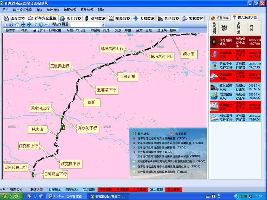 A map display of the GIS-based Qinghai-Tibet Railway Bureau comprehensive monitoring system. |
ArcGIS Desktop supports the data processing and provides statistical analysis tools with the Spatial Analyst and 3D Analyst extensions. Esri server and ArcSDE technology makes it possible to manage spatial data and publish it on the train company's intranet. ArcGIS Engine was used to develop applications for comprehensive operation monitoring and emergency response.
The main source of railway supporting data comes from CAD design data (collected from the planning and design department) and satellite imagery of the surrounding landscape. The laboratory also collaborated with Leador CO., LTD, to make a visual record of the tracks and landscape along the rail route including precise location coordinates for the images. Leador, a Chinese company in Wuhan City that specializes in mobile mapping and survey software, used a survey vehicle equipped with a camcorder, camera, GPS, and digital compass to record data. Additional data comes from digital elevation models (DEM), 3D models, and databases created in the ArcGlobe environment.
To resolve high-altitude communication and data transmission challenges, a Global System for Mobile Communications for Railway (GSM-R, which uses cellular phone technology) was provided by Nortel Network and Beijing Xidian. GSM-R transmits the real-time location of moving trains and other data to the control center.
Train Monitoring, Emergency Response, and Information Sharing
The control center fuses real-time monitoring information, such as train data (location, speed, staff, and passengers), passenger car conditions (temperature, balance), and the electrical system (voltage, current), and displays it on digital maps. Weather conditions and images along the route can also be retrieved. The operator can change the area displayed and zoom in on any particular section of the railroad line to a predetermined resolution. Message alert icons appear on the map to give the operator the location of any problems and point to the relevant data. Users are able to browse maps; query and display infrastructure features by location; retrieve geographic data, photographs, and video; and manage and search for metadata.
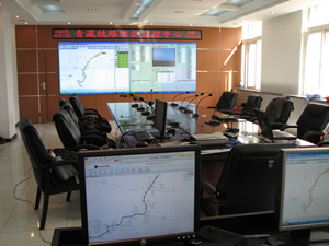 The control center for the Qinghai-Tibet Railway Bureau comprehensive monitoring system includes multiple screen displays. |
The center's emergency response system supports the emergency commander's need to capture, analyze, and process location data vital for organizing a response. The system uses ArcGIS technology to create a 3D visualization of the land surrounding a rescue scene and produce static rescue maps (e.g., maps showing potential helicopter landing zones). These printed maps provide information needed to coordinate rescue teams and relief trains and to identify possible sources of the problem. In addition, the center's intranet system provides a way to coordinate efforts with other sectors such as public safety, hospitals, and local authorities.
More information about the train is available by visiting the railway's official Web site at www.chinatibettrain.com. For more information about this and other transportation GIS applications, visit www.esri.com/transportation or www.esrichina-bj.cn or contact Esri China (Beijing) Limited by writing to info@esrichina-bj.cn.
About Esri China (Beijing) Limited
Esri China (Beijing) Limited is the authorized exclusive distributor for software from Esri—the world leader in geographic information systems—on the mainland of the People's Republic of China. For more information, visit www.esrichina-bj.cn.
About State Key Laboratory of Rail Traffic Control and Safety, Beijing Jiaotong University
The State Key Laboratory of Rail Traffic Control and Safety relies on state-level key disciplines, including Transportation Planning and Management, Traffic Information and Control, Communication and Information Systems, and Systems Science, which are top-ranking agencies in China. It integrates several key laboratories from provincial and ministerial levels.
Visit the Web site at http://rtlab.njtu.edu.cn/.
See also "Qinghai-Tibet Railway Sets Records."