Rebuilding after a Disaster
Efforts continue to supply aid to the victims of last January's earthquake in Haiti and to rebuild the homes, roads, and other damaged infrastructure. Several organizations are using geospatial technology to obtain supplies and food, assess damage, and start to reconstruct. (Learn more about how Esri is supporting these organizations' efforts.)
The article below details how GIS was used in Indonesia after a disaster of similar magnitude.
By Karen Richardson, Esri Writer
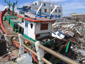 The tsunami in Southeast Asia ripped apart boats, roads, and buildings. |
Five years ago last December, on the day after Christmas, a magnitude 9.1 earthquake in the Indian Ocean set off a devastating tsunami. From the beginning, GIS played an important role in mapping the impact of the disaster, guiding emergency responders to the devastated areas, and coordinating the relief effort. Now the technology is being used in the process of rebuilding.
Waves of up to 30 meters high struck Southeast Asia during the tsunami. Almost 230,000 people in 14 countries lost their lives. But most of the damage was centered in Aceh province on the northern tip of Sumatra. The coastal region was leveled. Water rushed inland as far as four kilometers, in one instance carrying with it a 2,600-ton barge and depositing it to languish as a reminder of what had happened. Services and infrastructure throughout Aceh province were severely impacted. Water, sewer, and electrical systems were destroyed and had to be reestablished. Even transporting supplies and the labor force to the affected areas was hampered, because every single road along the west coast had been severely damaged or completely washed away in large sections.
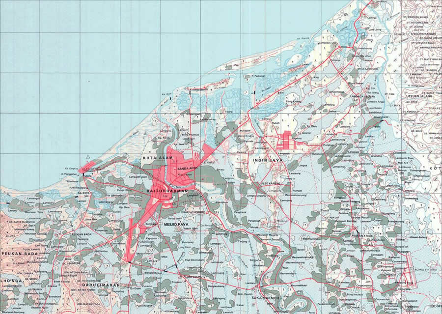 1:50,000-scale maps were available, but the tsunami rendered many of them out-of-date. | |
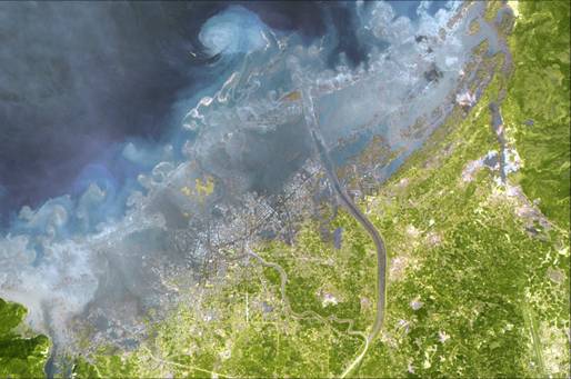 Satellite Imagery of the Changed Coastline | |
 Among the most valuable products the UN HIC produced was a map of where each relief organization was working after the tsunami. That information could be communicated quickly to relief workers scrambling to help people affected by the devastation. | |
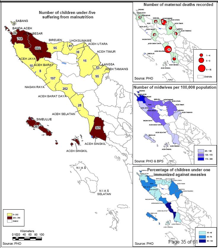 UN HIC worked with the World Health Organization to collect and evaluate data, using GIS to create an accurate picture of the damage and prioritize need. | |
 GIS was used to route trucks and ship goods efficiently throughout the region. (Credit: Joerg Meier, Aceh Besar) | |
 GIS was an invaluable tool in planning the infrastructure repair work. | |
 GIS maps helped agencies rebuild and repair more than 100 education facilities in the region, allowing children to return to school. | |
 Australian Government Overseas Aid Program (AusAID) funded the Asset Mapping Assistant Project (AMAP), which is managed by GTZ. AMAP facilitates the allocation of scarce resources and manages public assets. | |
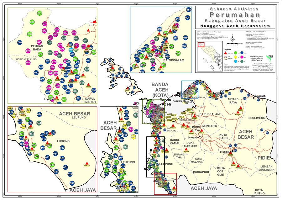
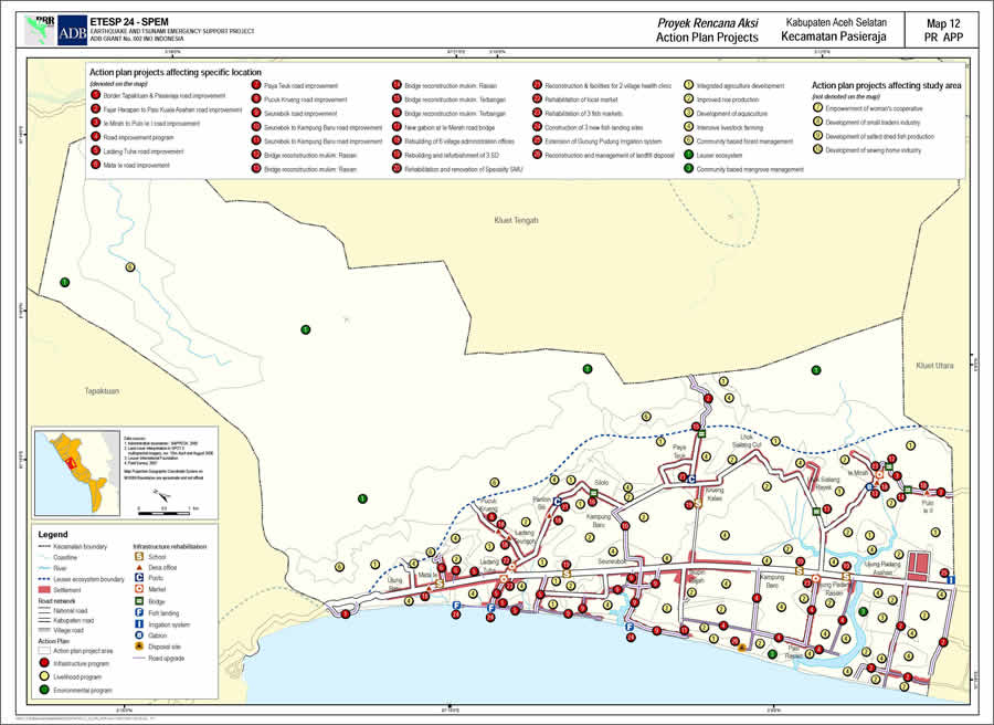 A sample map displaying infrastructure, livelihood, and small environmental projects was developed from field surveys, by talking to community members and analyzing spatial data. |
Seeing the region today, little evidence remains of the devastation, as Aceh continues to not only recover but also, as the government's motto says, build back better.
International Aid Agencies Rely on GIS for Fast and Efficient Emergency Response
The United Nations brought in GIS technology to assist in rebuilding Aceh. The Indonesian government and more than 65 nongovernmental organizations relied on the technology to help facilitate relief efforts, strategize management of health care, and begin to rebuild infrastructure. The organizations used GIS to produce maps for humanitarian work, including maps of injured populations, damage assessments, and displaced persons. Among the most valuable products that UN HIC produced was a map of where each organization was working, so information could be communicated quickly to relief workers scrambling to aid those affected by the devastation. Today, GIS continues to help Aceh province manage assets, reduce illegal logging of the Sumatran forests, and incubate new industries such as tourism.
Today, GIS continues to provide necessary insight into the information that helps Aceh province manage assets, reduce illegal logging of the Sumatran forests, and incubate new industries such as tourism.
To begin coordinating the relief effort, emergency responders needed to be guided to areas damaged by the tsunami. Maps were required to visualize where supplies should go and which organizations would be able to assist.
Since the tsunami tore up the shoreline, it was a challenge to find current and accurate geographic data for the region. The national mapping agency Badan Koordinasi Survei dan Pemetaan Nasional (Bakosurtanal) provided 1:50,000-scale maps, but what remained of the mapped infrastructure for the province was not always up-to-date.
"Unfortunately, disasters happen when we least expect them," said Erik van der Zee, GIS adviser for the spatial planning and environmental management component of the Earthquake and Tsunami Emergency Support Project (ETESP). The ETESP is supported by the Asian Development Bank (ADB).
"This emergency really exemplified the importance of countries investing in national mapping agencies to provide the information necessary to respond to catastrophes such as this," van der Zee said.
Where maps were rendered useless by either changed infrastructure or the tsunami's impact, the United Nations Humanitarian Information Centre (UN HIC) turned to high-resolution satellite imagery to supplement the vector base data. Since a complete image of the area was unobtainable due to heavy cloud cover, older topographic maps were also scanned.
Days after the tsunami, the UN set up HIC. Based in tents at the heart of the catastrophe, HIC collected data from the Indonesian government, nongovernmental organizations (NGOs), and international agencies. UN HIC delivered GIS data and maps to the responding humanitarian community, allowing workers to deliver assistance more effectively immediately after the emergency.
GIS Used during Tsunami Disaster Response
Apart from providing informative topographic maps to coordinate relief efforts, GIS was used in specific sectors during the initial response to the disaster.
Health
The most immediate concerns were to contain disease outbreaks and prevent more people from dying of starvation. Officials needed to know the location and number of survivors, as well as the extent of their injuries, to provide them with food, water, and medical supplies.
The UN HIC team, working with the UN World Health Organization (WHO), collated and evaluated data using GIS to create an accurate picture of the damage and prioritize needs. Activities were coordinated and prioritized; field hospitals and mobile health clinics were set up where needed. No major outbreak of disease occurred. There were few deaths, contrary to expectations after a disaster of this magnitude.
Mobile Resource Planning
Since the main west road and all seaports in Aceh province were unusable, transporting food, water, and medical supplies seemed nearly impossible. GIS was used to route trucks and prioritize shipments.
Infrastructure
Many groundwater reservoirs were polluted, sanitation at temporary shelters was an issue, and drinking water had to be trucked in to the area. GIS was used to identify risk areas and develop management plans.
Education
Since 50 percent of the schools in Aceh province were damaged or destroyed, GIS was used to decide where best to build new schools based on population density and proximity to health facilities. Damaged facilities were assessed to identify which schools could be rebuilt more quickly.
Housing
The simple act of providing shelter presented many challenges. More than a half million people were left homeless when land washed away and traditional landmarks vanished. Land that remained had to be cleared of millions of tons of debris and silt before it could be used again, and many areas were no longer suitable housing locations.
Workers from the international aid community went into the field to map where houses once stood and determine who owned the properties. Pseudo land titles were issued with the signatures of all neighbors and the village leader.
Initially, there was no mandate to coordinate rebuilding among the various agencies. Government staff used GIS to coordinate activities including spatial planning, village mapping, community planning, engineering design, and house building.
NGOs and the government worked together to rebuild Aceh's infrastructure, from houses to schools, hospitals to markets, and roads to bridges. Together, using GIS, the organizations made collecting, managing, and sharing information as timely as possible between many different stakeholders.
"As a result of the GIS data collection and compilation during the past five years of reconstruction, this area may be considered one of the richest provinces in terms of spatial data and information in Indonesia," said van der Zee.
Today, GIS and geospatial data is managed by the Aceh Geospatial Data Center (AGDC) of the Provincial Development and Planning Board in Aceh (BAPPEDA) and the governor's office. Yakob Ishadamy manages the AGDC. He managed the GIS work during the initial recovery. GIS centers have been established in six districts in Aceh province and are able to do basic GIS processing. GIS data is maintained with Esri GIS software and is available in shapefile format.
"GIS continues to have a role to play by providing information to government officials and others to support their efforts," said Ishadamy. "The reconstruction, economic, and social factors involved all have a time-and-space component. GIS provides an invaluable framework for building an information base and providing the best decision support, communication, and collaboration possible."