How GIS Is Helping in Haiti
By Jesse Theodore, Esri Writer
Organizations working to help Haiti recover after the magnitude 7.0 earthquake earlier this year are using GIS to make decisions related to getting aid to where it's needed and to rebuild infrastructure. Esri is working closely with the GIS community and agencies that responded to the quake in Haiti, providing organizations with software, technical support, GIS data, and personnel.
"Our job is to empower our users with better GIS support," says Russ Johnson, director of public safety solutions for Esri.
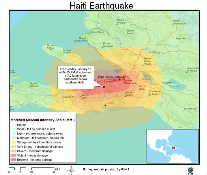 This map from the United States Geological Survey shows the earthquake's far reaching impact. |
The quake struck near Port-au-Prince on January 12. Government officials estimated that more than 200,000 people were killed. The destruction was widespread; many buildings collapsed, and about 1,000,000 people are still homeless, according to the Haitian government.
GIS is assisting in many ways including
- Identifying areas where damage is extreme
- Assessing how critical infrastructure has been impacted
- Pinpointing areas suitable for food and water distribution
The technology gives officials critical information for making all types of decisions.
Personnel and agencies working on the relief effort can take advantage of maps, data, software, and Web services available online through the Esri Web site www.esri.com/haiti. Some of the data and services include a 25-meter reference grid of Haiti, the Esri GeoViewer—a Flex-based map viewer that complements the Esri GEO Portal—and Haiti basemap data from the United Nations, available on ArcGIS Online. In addition, Esri-generated earthquake and recovery maps are available for both the media and the public. Esri will provide updates as they become available.
"As soon as we learned of the terrible disaster in Haiti, we activated our emergency operational procedures to assist emergency services, humanitarian relief, health professionals, NGOs [nongovernmental organizations], and others," says Johnson. These organizations are working extremely hard to make a difference."
As aid and rescue workers poured into Port-au-Prince and other regions, GIS assumed and continues to play an essential role in assessing priorities to get resources and aid workers to the areas hardest hit by the earthquake.
Organizations also are using GIS to support the development of long-term recovery plans. Today GIS is being used to determine how to leverage existing and functional infrastructure and help identify priorities to reestablish critical damaged infrastructure, says Johnson. In the case of destroyed infrastructure, GIS is helpful in selecting the sites for rebuilding transportation networks, electric utilities, and other facilities."