ArcWatch: Your e-Magazine for GIS News, Views, and Insights
March 2011
ArcGIS Online: A One-Stop Source for Geographic Content
Access More than 45,000 Maps, Apps, and Tools
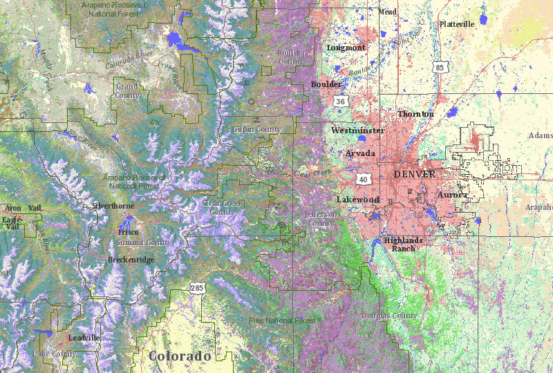
This web map presents multiple levels of land cover classifications for the continental Unites States and combines three levels of land cover from the United States Geological Survey's Gap Analysis Program (GAP).
You can now access more than 45,000 maps, apps, and other resources from ArcGIS Online, a rich repository of geographic content that's enjoying a surge in popularity.
Esri publishes content derived from commercial and other authoritative data sources. Users can freely access all this content, including web maps, map services, apps, and layer/map packages, through ArcGIS or a browser.
The volume of items shared publicly or through groups formed around common interests or industries, is on the upswing, thanks to 35,000 registered ArcGIS Online users who contribute content for others to use.
Sure to generate more interest: Esri now offers ArcGIS Online basemaps, which the company publishes and hosts, for free regardless of commercial, noncommercial, internal, or external use. You no longer have to pay a subscription fee for including ArcGIS Online basemaps in your web applications previously deemed revenue-generating applications for commercial use. Basemaps affected include World Imagery Map, World Street Map, World Topographic Map, USA Topographic Maps, and DeLorme World Basemap. The only restriction is a high-volume transaction limit of 50,000,000 transactions in a 12-month period, a volume that most likely very few users will reach. Local, state, and federal government users are not affected by this change. They can continue to make unlimited use of ArcGIS Online basemaps regardless of transaction volume. Developers also have unlimited access to ArcGIS Online basemaps for development and testing purposes via the ArcGIS Web Mapping APIs. Visit esri.com/mapservices to learn more about ArcGIS Online basemaps. Find answers to common questions about ArcGIS Online.
This map service presents information about current United States weather watches and warnings that have been issued by NOAA's National Weather Service (NWS).
Users looking for imagery services on ArcGIS Online will be interested in the new MDA NaturalVue imagery that has been published as a web map and as an ArcGIS Server image service. This provides a good example of how imagery can be published dynamically for use as an attractive basemap in GIS applications or as the source for applications of approximate georeferencing and color correction of smaller-scale imagery. MDA Information Systems, Inc., created the NaturalVue 15-meter satellite imagery of the world, a natural color seamless mosaic from over 8,600 Landsat-7 multispectral images. It's a single, consistent global dataset with a spatial resolution of 0.5 arc seconds and a positional accuracy of better than 50 meters root mean square error (RMSE).
Another dataset recently added to ArcGIS Online is the United Nations Second Administrative Level Boundaries (UN SALB). This authoritative dataset is published by the United Nations Geographic Information Working Group (UNGIWG). The organization's goal is to provide the international community with global, seamless, standardized datasets, country by country, that support comparative analyses for issues such as mapping the AIDS crisis, development in a particular region, or the movement of displaced populations in war torn conflict zones. Changes to borders and internal boundaries are updated frequently by respective mapping agencies, making this data extremely useful for international aid work around the globe. These datasets have been published under the UN SALB group in ArcGIS Online and can be downloaded as individual layer packages by country for use in ArcGIS Desktop.

The World Imagery Map includes satellite imagery for the world and high-resolution (1m or better) imagery for the United States and other areas around the world.
The National Maps for USA group in ArcGIS Online has been created with the federal user community in mind. This group features web maps, map services, and layer packages from several leading government and commercial providers such as the United States Geological Survey (USGS), the National Oceanic and Atmospheric Administration (NOAA), the United States Environmental Protection Agency (EPA), the United States Department of Agriculture (USDA) Farm Services Agency, the National Geographic Society, i-cubed, and Tele Atlas. This group's purpose is to provide basemaps or operational layers for use in web mapping applications or to create simple mashups together with other map layers. Some examples include the
- US Land Cover Map, a web map that presents levels of land-cover classification for the continental United States based on Landsat 2001 imagery
- Soil Survey Map of USA, a web map that features the Soil Survey Geographic (SSURGO) Database by the USDA's Natural Resources Conservation Service
- USA National Wetlands Inventory, a web map that displays wetlands and deepwater habitats based on the National Wetlands Inventory published by the US Fish and Wildlife Service
- USA Thunderstorm Probability Forecasts, a web map that references a thunderstorm probability forecast map service (Updated hourly, it's published by the National Weather Service [NOAA/NWS]).
To start using maps, apps, and other resources, visit ArcGIS.com, the web portal for all ArcGIS Online content.