ArcWatch: Your e-Magazine for GIS News, Views, and Insights
March 2011
Consuming GeoRSS Feeds Using ArcGIS Desktop
As access to real or near real-time data feeds becomes faster, easier, and less expensive, you will need ways to consume this data and view it in different applications. One example of a real-time data feed is GeoRSS. You've probably heard a lot about GeoRSS lately. Really Simple Syndication (RSS) is the most well-known web feed because it can be extended to publish any sort of itemized data to an application, but GeoRSS has gained popularity in the last few years because it has an added benefit: location or geographic coordinates are encoded as part of the web feed. This allows web developers to add geographically referenced data feeds to web applications.
There are many web-based applications for consuming these types of feeds, including the ArcGIS APIs for Silverlight, Flex, and JavaScript. You also can use the Data Interoperability extension in the ArcGIS Desktop ArcMap application. This extension allows you to easily use and distribute data in many formats, including RSS or XML, without needing to convert it to a readable format first. With this option, you can not only visualize the data from a GeoRSS feed but also manage the data and analyze it for patterns and trends.
Here's how to do that using, as an example, a GeoRSS feed from the United States Geological Survey (USGS) on recent high-magnitude earthquakes.
Step 1: Turn on the Data Interoperability extension in ArcMap by clicking Customize, pointing to Extensions, and clicking Data Interoperability.
Step 2: Add a new interoperability connection in the Catalog window in ArcMap by expanding the Catalog window and double-clicking Add Interoperability Connection.
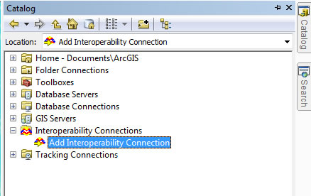
View of Catalog Window and Add Interoperability Connection Link
Step 3: Once the Interoperability Connection dialog box opens, click the ellipsis button next to the Format input box.
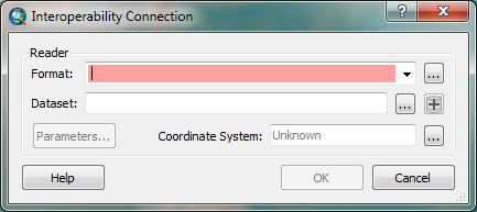
Choosing the Data Format within the Interoperability Connection Dialog Box
Step 4: Browse to GeoRSS/RSS Feed within the gallery. Select it and click OK.
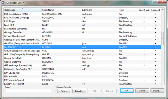
Gallery of Formats Read by the Data Interoperability Extension
Step 5: Copy and paste the GeoRSS URL for worldwide earthquakes greater than magnitude 5 from the USGS website (earthquake.usgs.gov/earthquakes/catalogs/eqs7day-M5.xml) into the Dataset input box, then click OK. You can change the parameters of how the feed is parsed out by clicking the Parameters button. You now have a new connection in the Catalog window.
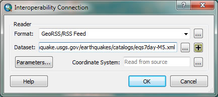
Inputting the URL within the Interoperability Connection Dialog Box
Step 6: Drag and drop the Entry Point layer into your active ArcMap data frame to view the data.. Once in ArcMap, you can symbolize the data as you see fit and begin to query and analyze this new dataset.
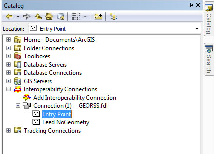
View of GeoRSS Feed in Catalog Window
Step 7: Once the data is added to ArcMap, it's a static snapshot of the feed at the time it was added. To handle updates, the data frame or layer must be refreshed. Right-click the layer and choose Refresh from the menu to pull down the most up-to-date information.
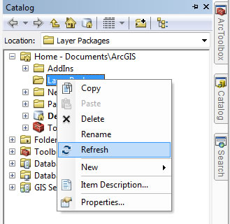
View of Catalog Window and Layer Menu Options
To learn more about GeoRSS, read the GeoRSS blog. To learn more about using GeoRSS feeds, read the blog article GeoRSS Feeds in ArcGIS Explorer or the blog article Social Media and Geo-Services.