Michels Corporation, an International Engineering and Construction Contractor, Adopts ArcGIS Server
By Karen Richardson, Esri Writer
A motto on the Michels Corporation Web site says, "We embrace change as only an innovator can."
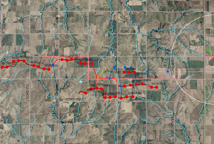 Field staff working at the Meridian Way Wind Energy Project in Cloud County, Kansas, use maps produced by ArcGIS that combine imagery and vector data. These maps are used in field collection units loaded with Esri ArcPad software and also as standard hardcopy maps. |
The international engineering and construction contractor's willingness to be innovative extends to its decision to widely adopt geographic information system (GIS) technology including the most recent addition to the company: Esri's ArcGIS Server.
The Brownsville, Wisconsin-based firm, which has grown from humble beginnings as a pipeline construction company almost 50 years ago, plans to use ArcGIS Server in several ways including creating Web applications that will let the company and customers exchange project information.
Michels decided to invest in GIS software because it offered the ability to visualize the company's assets and to plan for future projects and development. "GIS technology has helped Michels plan and execute projects for our customers," says Pat Michels, the chief executive officer (CEO) of Michels Corporation, named one of the top 100 contractors and one of the top 10 utility contractors in the United States by Engineering News-Record. "We view our use of GIS as an important step in enabling Michels to be more collaborative in our interactions with clients."
Michels, a family-owned business, designs and constructs infrastructure for utility, energy, communications, and transportation and distribution industries. The company takes pride in its innovation and leadership in the marketplace, always looking for a better way of doing business.
Esri had already demonstrated itself to be the industry standard and was being used by many of the companies and agencies Michels works with daily. Because of that, the company decided to use Esri's ArcGIS software to better communicate with clients who also use GIS for utility infrastructure planning, design, and bidding.
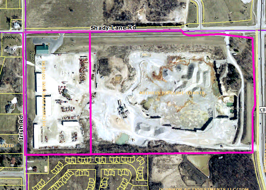 ArcGIS Server and Microsoft SQL Server are used to organize, inventory, and track corporate holdings around Winnebego County, Wisconsin, making it easy to access the data through Web applications or desktop GIS and as hardcopy maps. |
The company first tried ArcGIS in 2004 to assist in asset management and to track permits. Dave Melum, environmental compliance specialist in the Michels Materials Division, says GIS allows him to see and analyze this information by location, giving the division a better understanding of their real estate holdings, property leases, and local and state permits. Furthermore, he is able to quantify future reserves by mapping the aggregate resources, operations permits, and test sites.
The adoption of ArcGIS also lets Michels manage the deployment, performance, and maintenance of the company's organizational assets. This is leading to cost and time savings through improving equipment and staff productivity, reducing capital outlays, and enabling better decision making. The corporation can now recognize assets that were being underutilized and is working to eliminate holdings with limited strategic value based on market conditions and future development. ArcGIS helped solved the problem of inefficient collaboration between different corporate groups handling real estate, permitting, and project information.
Michels' officials have found that GIS provides the tools they need to analyze every facet of their building design work and how it relates to its environment. For example, they use GIS to find out how future growth of a community will affect the pattern of streets and community services. They also use it to solve construction layout problems and provide a new way of thinking about predesign analysis.
Doug Heider, officer of special plans/GIS manager of Mi-Tech, Michels' engineering division, uses GIS for design and management of information for third-party clients including telecommunication companies nationwide. "Adding ArcGIS to our engineering toolbox allows us to provide many value-added benefits for our current customers and better communicate with our customers throughout the life of their project from design to construction status to as-builts. By creating our project data in real-world coordinates and using our software's data interoperability, we can create a standardized method to interact with the many entities that are normally involved in large utility construction projects," Heider says. "It is not uncommon to have to deal with five or more permitting agencies including multiple cities and counties, DOT [Department of Transportation], DNR [Department of Natural Resources], railroads, and other utility companies. Esri software gives us the tools we need to bring together the multiple dataset types that come with dealing with all those different entities. At the end of the projects, we are able to provide our customers with very accurate and feature-rich as-builts in any format they wish. This is becoming important, as most government agencies have adopted GIS technology and many are requiring as-builts be sent to them in a format compatible with their software."
 Michels has found ArcGIS to be a useful tool for identifying potential aggregate resources for use in building projects. Soil layers can be queried to determine which have characteristics for near surface gravel or bedrock. Next, parcel data is overlayed so property owners and acreage is identified. Then, as this map displays, different colors are used to differentiate between the resources and given a 30 percent transparency so open land is easily identified. |
Michels adopted Esri's ArcGIS Server software to support an even wider range of internal operations as well as provide a platform for job tracking by its clients. ArcGIS Server is a complete and integrated server-based GIS and offers a low cost of ownership through centrally managed, focused GIS applications that can scale to support many users. It allows browser-based access to GIS and integrates with other enterprise systems, such as customer relationship management (CRM) or enterprise resource planning (ERP), using industry-standard software. ArcGIS Server provides the foundation to enable a geospatial service-oriented architecture (SOA).
To oversee the deployment of ArcGIS Server, Michels recently hired Phil Paradies as GIS manager. As part of the ArcGIS Server implementation, Paradies started an enterprise-wide GIS database on ArcSDE. He has been transferring geospatial datasets that were acquired during the previous two years and adding new geospatial data from around a nine-state operating area. "I felt that once we had a fairly substantial SDE database, we could then start to create various Web apps. and mashups using ArcGIS Server," says Paradies. "ArcGIS Server allows us to easily deploy our corporate spatial data alone or combined with other data sources from Web Map Services (WMS) servers to our employees and clients alike. We'll be able to leverage these capabilities even more as we begin to migrate the disparate, nonspatial databases to centralized corporate database servers and link them to our spatial layers in GIS."
Michels plans to use ArcGIS Server to keep it a step ahead of the competition by providing Web applications to exchange project information with customers and improve operational efficiencies and organizational communications. "GIS is the future, and we are very certain that our use of this technology will benefit Michels in how we can better serve our customers," says Michels.