ArcGIS 10 Improves Productivity and Makes GIS Widely Available
ArcGIS 10 will transform the way people use and apply GIS.
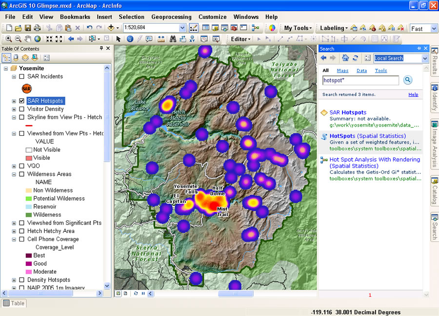 Quickly locate maps, data, and tools with the new Search window in ArcGIS 10. |
The release, expected to ship during the second quarter of 2010, will help users be more productive and provide them with more powerful spatial analysis capabilities while significantly improving performance. Users will now be able to leverage GIS widely via Web-extended desktops, Web-hosted applications, and the cloud.
Perform GIS Work Faster
ArcGIS 10 dramatically improves the user experience and integrates productivity tools to support the workflows of GIS professionals. This release makes creating and producing maps much easier and provides best practices templates to help users get started quickly. At ArcGIS 10, users can search by keywords or data types to find data and maps. They can also use the search function to quickly and easily find symbols to use in their maps and tools.
Editing in ArcGIS 10 is streamlined. The release introduces sketch-based desktop and Web editing, which means that users can choose from a customizable on-screen palette of features in desktop and Web clients. Besides improving efficiency, ArcGIS 10 provides tools that let users do more work with volunteered geographic information on the Web.
Faster performance at ArcGIS 10 is the result of improved cache generation and management, as well as optimized Web graphics. These caching and Web graphic improvements translate into more responsive drawing performance, including smooth, continuous panning of data.
Powerful Spatial Analysis
With this release, Esri continues to advance geographic science with additional spatial analysis tools. ArcGIS 10 includes Python scripting for automating common tasks and analyses. Using Python, ArcGIS capabilities can be combined with other scientific programming to create powerful solutions. Among the new capabilities for analyses offered in ArcGIS 10 is location allocation, which helps users understand how placement of their facilities in a given network impacts their ability to serve customers.
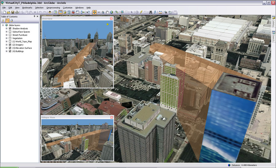 As a full 3D GIS, ArcGIS 10 offers 3D data models, editing, analysis, and visualization. |
The upcoming release also introduces the notion of time in both visualization and analysis. ArcGIS 10 lets users create, manage, and visualize time-aware data. Users can display and animate temporal datasets, as well as publish and query temporal map services. Being able to see data over time gives users the ability to do more in-depth analyses.
ArcGIS 10 makes it much easier and faster to perform 3D visualization. ArcGIS becomes a full 3D GIS, offering 3D data models, editing, analysis, and visualization. Users can do virtually everything they do in a 2D environment in 3D.
Improved Imagery Use and Management
ArcGIS 10 enables better use and management of imagery on the desktop and server. This release supports massive dynamic mosaics, resulting in fast performance. On-the-fly processing previously supported on ArcGIS Server is now also supported in ArcGIS Desktop. Moreover, access to commonly used imagery management tools is easier at ArcGIS 10.
New Ways to Share
ArcGIS 10 is tightly integrated with ArcGIS Online search and share capabilities, making it easy to create and distribute projects that include data, layers, maps, tools, scenes, globes, diagrams, and add-ins. It is also easy to find and organize geographic data throughout the enterprise via the new ArcGIS Server Search service.
GIS in the Field
At ArcGIS 10, ArcGIS Mobile offers a customizable, out-of-the-box application that allows users to extend mobile projects to in-vehicle and tablet-based PCs. Esri is extending this concept to the iPhone platform. Customers will be able to access a mapping application directly from the Apple iTunes App Store. Esri is also providing a software development kit so organizations can build their own focused iPhone applications.
For the latest information about ArcGIS 10, including podcasts and videos, visit www.esri.com/whatscoming.