Federal Audience Focuses on GIS for the Nation
By Emily Vines, Esri Writer
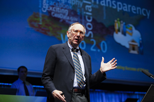 Esri president Jack Dangermond previewed ArcGIS 10 for the audience at the 2010 Esri Federal User Conference in Washington, D.C. |
How is GIS improving government today? How will geospatial technology evolve in the future? Those questions and others were answered during the 2010 Esri Federal User Conference (FedUC), which drew close to 3,000 members of the government to Washington, D.C., for three days in February. Attendees were predominantly from the federal government, but state and local leaders also showed up to learn about trends in GIS and innovative applications.
During the Plenary Session, Esri president Jack Dangermond spoke about his vision for GIS as well as what users can expect from ArcGIS 10, which will be released soon:
"A new vision for GIS is emerging," he said. "This is an easier GIS. [It's] more extensible. [It's] a system that is more collaborative, that's inclusive of everybody, and it's being enabled by trends like Web services, information integration, crowd sourcing, new data types, and new policies being advocated for open data sharing."
Version 10 offers hundreds of improvements including tools to create, manage, and visualize time-aware data; mapmaking time-savers; enhanced editing and sharing capabilities; more powerful spatial analysis, especially with new tools such as location allocation; the ability to perform editing, modeling, visualization, and analysis in 3D; improved access to imagery; and expanded availability of GIS in the field. Developers will also find it easier to build applications with Web APIs and software developer kits (SDKs) included in ArcGIS 10.
"ArcGIS simplifies working with a GIS," Dangermond said. "Version 10 puts up front, as a kind of user interface, a much simpler thing to work with: a map." This is a big step in the direction of simplification around the map—not only being able to interact and pan and zoom with a map, but also query a map, edit maps, combine maps, and share maps.
Dangermond elaborated on the emerging importance of volunteered geographic information (VGI) that enables citizens to share observations with government, such as streets that need repair, as well as opinions. "With crowd-sourced data, each citizen can be a sensor," he said.
 More than 3,000 government employees from all across the country attended the conference. During this session, Dangermond talked about ArcGIS 10 being "cloud ready." |
Dangermond also spoke about the new trend toward Gov 2.0 initiatives, which are being driven by open government and place-based policies of President Barack Obama's administration. As government embraces Web 2.0 technology, Web-based GIS applications are increasingly encouraging citizens to get more involved and increasing government transparency and accountability. Esri staff demonstrated real-world examples including the United States government's www.recovery.gov site and the GIS Web site of the District of North Vancouver in British Columbia, Canada (www.geoweb.dnv.org), which boasts, "Open Data. Free Maps. Rich Applications." The Web site was created so the public can access mapping, census, land, environmental, zoning, building, and other information related to the municipality.
"You, as GIS practitioners, will be called on in multiple ways in this new age to explore ways to [develop] more effective place-based approaches, to connect with citizens, to become more engaged with citizens, to work on various missions, to collaborate with your colleagues in other agencies," Dangermond pointed out.
He also announced that ArcGIS 10 is cloud ready and that Esri has a new relationship with Amazon Web Services to host ArcGIS in its cloud.
Earl Devaney, chairman of the federal government's Recovery, Accountability, and Transparency Board, spoke at the FedUC's closing session about how GIS is used at www.recovery.gov to show, for example, which organizations received stimulus funding and how much.
In addition to hearing insightful speeches during the opening and closing sessions, attendees learned more about GIS from one another at user group meetings and technical workshops, during paper presentations, and at the GIS Solutions EXPO.
To find out more about the FedUC and watch the plenary videos, visit www.esri.com/feduc.