ArcWatch: Your e-Magazine for GIS News, Views, and Insights
April 2011
2011 Esri Developer Summit
Developers See Vast Application-Building Possibilities with ArcGIS
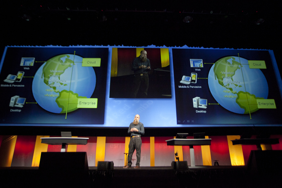
Esri is increasingly developing for the web/cloud and mobile device environments, said Scott Morehouse, Esri's director of software development.
Software developers Mark Ping and Adam Knight recently attended their first Esri Developer Summit, where they got a glimpse of how they will use GIS technology to develop applications in the future.
The future looks promising. "The possibilities are enormous. My eyes are being opened," said Knight, impressed by a demonstration of ArcGIS Server 10.1 performing—in mere milliseconds—the calculations to create drive-time polygons while rapidly receiving demographic data for those areas.
That demo sparked applause from the audience of more than 1,350 developers, who gathered in Palm Springs, California, in early March 2011 for the world's largest developer summit devoted to GIS. They came to learn how to use Esri technology when developing applications for desktop, web, and mobile technologies; share best practices and development patterns; exchange ideas and solve problems; and see what's on the horizon for the ArcGIS system. They also got a sneak peak of what's being developed for ArcGIS 10.1, which will be in beta in June and is slated for release in late 2011 or early 2012.
The summit largely drew desktop application developers, but developers for web and mobile technologies were well represented too. ArcGIS supports multiple implementation patterns, including those that are rapidly emerging for cloud/web and mobile GIS.
That pleased Ping, a big fan of the Android operating system that's on his smartphone. "I'm impressed with the smartphone platform," he said after watching a demonstration of ArcGIS for Android. Esri will also offer an API for building GIS-enabled applications for Android devices. Both the app and API will be released this spring. "I see the [Android] platform as dominating the mobile market, so I'm glad to see Esri embracing it," Ping said.
Bringing New Applications to Life
Esri president Jack Dangermond opened the summit by emphasizing the important role that developers play in bringing new applications that utilize Esri technology to their users. "Increasingly, there's a gap between what we develop and what needs to be developed to make people really productive," said Dangermond, adding that this is where the developer community steps in. "That takes special talents. It takes the talent of understanding what's needed and wanted, then engineering—thinking through, designing, and creating—that special application that really works."

More than 1,350 people attended the 2011 Esri Developer Summit.
Scott Morehouse, director of software development for Esri, echoed Dangermond's sentiment about the collaborative spirit. "We're here together because we want to build great stuff," he said. "Our purpose is to build a platform for working with maps and geographic information, which you can leverage to do great work. The goal is to create systems of information that bring geographic data and understanding about the real world to life for real people."
Going forward, Morehouse said Esri is increasingly developing for the web/cloud and mobile device environments.
"We are moving more functionality from the enterprise style of system building into a cloud or web style of system building," he told developers. "We are looking to move our services architecture into a hosted environment. We will move more desktop functionality into lightweight mapping applications that run on [smart]phones and [other mobile] devices and in browsers."
ArcGIS Online
Sud Menon, from Esri's software development team, described ArcGIS Online as being "ArcGIS available to you as an online, cloud-based system." Accessible using ArcGIS Desktop, web and mobile apps, or the ArcGIS.com web site, ArcGIS Online offers free access to maps, apps, and tools published by Esri and other GIS users. ArcGIS Online users, which now number more than 60,000, also can create and share maps within a community of interest or with everyone. Esri's Jeremy Bartley demonstrated ArcGIS Online and ArcGIS Explorer Online, showing the newly added support for time, editing, and pop-up windows. "Great web maps need great pop-ups," he said, showing the developers how to configure pop-up windows using the USA Household Income map as an example. "It makes for a compelling map when you can provide key information to your user."
Mobile GIS
Dave Cardella, product manager, Esri mobile technologies, said that ArcGIS runs on many mobile platforms and devices. "We have ready-to-deploy applications and APIs. The applications are configurable. Some of them are customizable. They are all built on an API we make available for you," he said.
ArcGIS offers excellent solutions for the Windows Mobile platform, Cardella said, noting that new functionality is currently being added to ArcPad and ArcGIS Mobile applications and software development kits (SDKs) to improve both customization and the overall user experience. "The smartphone and tablet market has really exploded. We see these devices increasingly being implemented within organizations that want to extend the reach of their GIS from the office out into the field," said Cardella. "They want to replace their paper-based workflows and improve the currency and the accuracy of their data—all in an effort to make more timely and accurate decisions. Since we last met, we have been hard at work improving the capabilities and tools you need to build solutions for these platforms."

The balmy Palm Springs, California, weather drew developers outdoors during the breaks between sessions. The Esri Developer Summit was held at the Palm Springs Convention Center.
For iOS and Windows Phone, Esri offers both a deployable application and an API that now include data collection and editing capabilities. The ArcGIS for Android application, which will have the same data collection and editing capabilities, is slated for release by May 2011, while version 1 of the API is scheduled for official release in April 2011.
For all these applications, users can add attribute information; edit points, lines, or polygons; and add attachments such as images, movies, PDFs, and Microsoft Word documents, Cardella said.
ArcGIS Portal
As part of the release of ArcGIS 10.1, Esri will offer customized versions of ArcGIS Online for use behind a firewall. ArcGIS Portal, a software product that will run in an organization's private cloud, will offer the same collaboration and sharing tools as ArcGIS Online but in a secure, on-site environment to protect proprietary, sensitive, or confidential data. The portals will become the central repository for authoritative content that users inside organizations can access to
- Quickly create maps and apps using templates and web mapping APIs.
- Form groups to collaborate on projects or common activities.
- Share maps and apps with private groups or the entire organization.
- Embed maps and apps in custom web pages or blogs.
Configurable Web Client Viewers
Esri's Art Haddad demonstrated ArcGIS Viewer for Microsoft Silverlight, a site starter application for creating a web client viewer for ArcGIS Server and ArcGIS Online services. It is built on ArcGIS API for Microsoft Silverlight. It includes an application builder that enables users to quickly and easily create a fully functional, custom web client viewer through an intuitive application user interface that includes a What You See Is What You Get (WYSIWYG) preview. No programming or configuration file editing is required. This is ideal for nondeveloper users and novice web application creators. It is currently available in public beta from the Esri Beta Community site. Mansour Raad from Esri also demonstrated an early prototype of the ArcGIS Viewer for Flex application builder. Both viewer application builders are targeted for release at the 2011 Esri International User Conference (Esri UC).
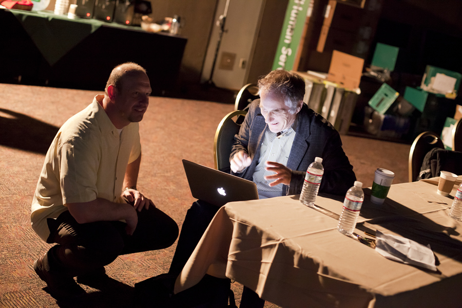
Jim McKinney (left), ArcGIS program manager for Esri, helps Tim O'Reilly, founder and chief executive officer of O'Reilly Media, prepare for his presentation at the Esri Developer Summit. O'Reilly spoke in part about how developers can use technology to build applications, services, and systems that can solve problems and make the world a better place.
For a complete overview of the plenary, held March 8, 2011, watch these videos.
"Heart of the Summit"
ArcGIS program manager Jim McKinney called the technical sessions the "heart of the summit." There were 30 user presentations this year, including A Year of Silverlight—Tips and Tricks; Designing a GIS App for the Facebook Generation; Cloud Love: Moving Off-Premises Step by Step; and Becoming a Python Developer: Leveraging the Language and Community Tools.
Esri also hosted 70 technical sessions, including Choosing a Mobile Development Platform; Building and Using the Esri Social Media VGIS Mapping Application; ArcGIS for Defense/Intel—A Developer's Guide; Creating, Managing, and Utilizing a 3D Virtual City in 10; ArcGIS 10.1 and the Road Ahead; Building Secure Applications; and Python for Working with ArcGIS.
Challenge Winners
Developers participated in two challenges at the Esri Developer Summit. The Light Up the Night Challenge brought developers together in a theater-style room. They were given three hours to solve one of three challenges, which Art Haddad presented to them. Even though the weather outside was unusually cold with sputtering rain, the atmosphere inside was warm and energetic.
Jarrod Skulavik won first place with his National Renewable Energy Laboratory (NREL) Wind Turbine Potential (Western US) application. He won an Xbox360 with Kinect that Microsoft donated, a free pass to next year's Esri Developer Summit, and the Light Up the Night Challenge trophy. Read about the other winners.
Frank Roberts' Street View and More—Widget for FlexViewer 2.* took the top prize in the Flex-a-Widget Challenge. He won Adobe's Creative Suite for the web, donated by Adobe; a pass to the 2012 Esri Developer Summit; and an Esri Developer Network (EDN) subscription. Read about the second- and third-place winners.
Seeing What's Possible

A basket full of Esri buttons.
Ping said the Esri Developer Summit proved to be an excellent source for information about Esri's upcoming plans, which in turn will help his company's "development cycle to be future- ready."
"I was blown away by what was shown in progress for 10.1, in particular the improved performance and increased support for and emphasis on Python," said Ping, a senior software developer for VESTRA Resources, Inc., in Redding, California. "It absolutely justifies our efforts to build reusable tools in Python and train [our] GIS experts in the programming language."
Knight, who also works at VESTRA as a software developer, was struck by the improvements in speed in ArcGIS 10.1, the new ArcGIS Viewer for Microsoft Silverlight, and the enhancements in ArcGIS API for Microsoft Silverlight.
Being new to the Developer Summit, he said he arrived in Palm Springs with some preconceived notions. "I think I was expecting to be trained on how to do certain things," said Knight. "Once I realized this wasn't the case, I was able to get much more out of it. I realized that the purpose of the Dev Summit was to show us as developers what is possible and how we can use Esri's technologies. Though I definitely did learn how to do some things, I know what is possible and can now go learn how to do it."
Resources
Keith Mann from Product Marketing at Esri contributed to this report.