New Conservation GeoPortal Taps into a World of Maps and Data
By Frank Biasi, Director, Conservation Projects—National Geographic Maps
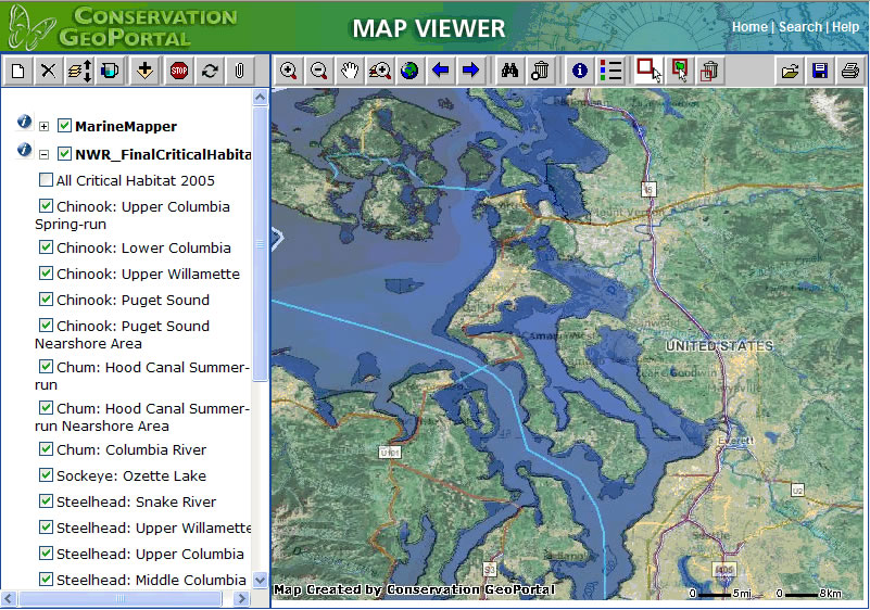 Map Viewer allows users to display, combine, and query live map services and save and share map views. |
Nature conservation is a complicated business, regardless of the scale at which it's done. Doing it well involves collecting and analyzing a variety of information about the natural and human environment and deciding which species or ecosystems should be conserved, what factors impact them, and which conservation strategies should be employed and where.
Fortunately, a vast and growing amount of data exists to assist scientists, ecologists, and others working on conservation projects. Unfortunately, that data is scattered and sequestered throughout thousands of organizations (and held by thousands of individuals) worldwide, which makes it largely inaccessible. Thus, finding good data to support conservation projects is a fundamental problem whether you're an environmental planner, a scientist, a policy maker, a resource or park manager, a communications specialist, or a graduate student.
To help people working in conservation locate this elusive data, a group of organizations working under the umbrella of the Conservation Commons recently developed the Web-based Conservation GeoPortal (www.conservationmaps.org). It was created to help solve the problems of finding, evaluating, and sharing data and maps for conservation.
The GeoPortal makes mining the vast amount of information that is relevant to conservation easier and provides a convenient place to publicize information for others to discover and use. It provides a deep catalog of data and maps that can be searched by keyword, geography, or content type as well as a powerful map viewer to display, combine, and share live map services. The GeoPortal is tailored to the conservation field including curated "channels" to quickly browse for premier data and maps by conservation topic or organization.
Leading with Metadata
It's important to note that the GeoPortal does not store or serve data and maps but rather the metadata records that describe and link to resources hosted by different organizations. In this way, it lets data providers control access to their data and maps and allows users to obtain the most current information directly from the source. Further, the GeoPortal is not owned or managed by a single organization but is managed collaboratively by a group of conservation-minded organizations under the principles of the Conservation Commons (www.conservationcommons.org).
The GeoPortal was conceived when representatives from a group of conservation-minded organizations met at the National Geographic Society in March 2005 to define a vision for a World Conservation Basemap. This conservation basemap would provide authoritative GIS data to conservation practitioners, scientists, educators, and decision makers to communicate environmental plans and policies and conservation issues to various audiences. The vision of a conservation basemap involves collaboratively developing and managing key GIS data layers, such as conservation areas, species ranges, and ecosystems, as well as reference layers, such as roads and water bodies, none of which are complete, accurate, or available worldwide. These data layers would then be used to produce a rich and accessible conservation atlas or atlases, both online and in print.
The members of the group decided to initially focus on developing an inventory or catalog of datasets and maps in the form of a metadata database that could be mined to develop the Conservation Basemap and Atlas. They knew this catalog would also be useful on its own, with or without the basemap and atlas components. The catalog became the Conservation GeoPortal, which was collaboratively designed, developed, and launched in fall 2006 under the domain ConservationMaps.org. Esri developed and hosts the site for the Conservation Commons, using its GIS Portal Toolkit and ArcWeb Services technologies. The site and its contents and functionality are free for anyone to use and contribute to.
Creating Mashups on the GeoPortal
Since its launch, thousands of metadata records have been entered into the catalog by individual users and through the harvest of other catalogs. Users can find information about protected areas, conservation priorities, species distributions, habitats, threats to biodiversity, environmental factors, socioeconomic data, satellite imagery, and basemap layers through simple keyword searches or advanced searches that combine keywords, geographic extents, data themes and formats, and dates. Users can read the metadata to determine if the map or dataset meets their needs, and if so, click a button to download the file. Search queries can be saved to run later as new content is added.
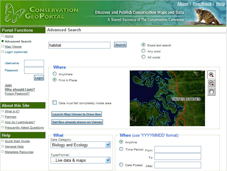 Advanced Search screen allows users to perform complex data searches that combine keywords, geographic extent, data categories, and timeframes. These searches can be saved and re-executed later. |
If the metadata describes and links to a live Internet map service, users can view and interact with the map service within the GeoPortal's Map Viewer, which streams the data in directly from the publisher's map server. With the Map Viewer, users can zoom and pan, identify features, and save the map view to open later or share with others via a permanent URL that can be e-mailed or added to their Web sites. What is especially unique and useful is that the Map Viewer lets users overlay or mash up data layers from different map servers, which may be hosted by different organizations using different protocols (e.g., ArcIMS, Web Map Server [WMS]).
For example, by searching the catalog, users could discover three different map services, hosted by the Nature Conservancy, Conservation International, and World Wildlife Fund, delineating conservation priority areas. Then, with a click, these live maps can be overlaid together in the Map Viewer along with a satellite image backdrop from the National Aeronautics and Space Administration (NASA). Users could then zoom and pan to their area of interest, turn layers on and off, adjust transparencies, and save that map view to a URL, which they can e-mail to their colleagues to show how various priority maps compare. When their colleagues click the link, the exact same map view opens, allowing them to work with the live map, perhaps adding map services or posting the link to the map view on their Web site.
This type of functionality is changing the concept of a map from a static image created and published by a single author at a specific point in time to a dynamic customizable geographic view that combines the most current data, in real time, from disparate data sources across the Web. Maps are no longer products but instead have become services.
The GeoPortal will evolve over time to include greater functionality and performance, plus a great deal more content. Enhancements may include an improved map viewer, multilingual support, RSS feeds, a map gallery of really cool maps, and better tools for users to create and manage their metadata records. The big push now is to get every organization and individual that possesses or knows about relevant data and maps to create and publish metadata describing those resources.
The Conservation GeoPortal can become an enormously valuable tool for data consumers and creators if it accumulates enough content and saves enough time to satisfy users. If this happens, it will be much easier to incorporate the best available information into conservation decisions and communications, which will maximize conservation investments and help us all do a better job saving the planet.
Frank Biasi is the director of Conservation Projects for National Geographic Maps, where he works on a variety of conservation-related mapping projects and Web sites. He also serves as executive editor for the Conservation GeoPortal and is a member of the Conservation Commons Steering Committee. He has been developing and managing GIS projects in the nonprofit and public sectors for 17 years.