Esri Education User Conference
When: July 11-14, 2009
Where: Hilton San Diego Bayfront in San Diego, California
Keynote speaker: Dr. Henk Scholten will speak about the role of GIS in the development of spatial thinking.
Register today
Ten Excellent Reasons to Attend the Esri Education User Conference
By Angela Lee and Joseph Kerski, Esri Education Programs
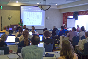 Esri Instructor Kerri Manorek leads a Hands-On workshop that focuses on customizing ArcGIS. | |
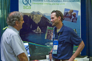 Ben Butler of the Student Conservation Association describes GIS internships at the EdUC Expo. |
Attending a professional conference such as the Esri Education User Conference (EdUC) means investing a considerable amount of time and money. So it's smart for educators, administrators, and others, to ask themselves what benefits they will receive by participating. To help attendees and their organizations understand the value of the EdUC, we've compiled a list of the top 10 reasons to attend.
- Get the big picture. You will see the state of the art in GIS technology, including improved tools for sharing data and publishing maps in ArcGIS 9.3.1 and the new features in the redesigned ArcGIS Explorer, such as a new ribbon interface. You also will get an update on Esri's programs to support educators, including new curricular materials, changes on the Education Community Web portal, and new initiatives from the Esri education team. Putting this all in context will be the keynote presenter, Dr. Henk Scholten, professor of spatial informatics in the Department of Business Economics at the Free University in Amsterdam and scientific director of the university's spatial information laboratory (SPINlab). Scholten will talk about the role of GIS in the development of spatial thinking and the importance of developing students' spatial thinking skills to help them prepare for tomorrow's challenges.
- Learn how GIS enhances education. Discover innovative ways to teach GIS from your peers during the user presentations. You also will have the opportunity to talk about how you use GIS in the classroom and what you have learned about GIS education. User presentations are organized by track to help you focus on what's most relevant to you, including the use of GIS in teaching, community projects, and administration and policy as well as research into the efficacy of GIS in education. A special joint track open to attendees of both the EdUC and the Esri International User Conference, being held July 13-17 in San Diego, will explore advances in geographic information science (GIScience), the theoretical and scientific foundation of GIS.
- Strengthen your community. Talk with students, youth program coordinators, and community leaders who are using GIS to address real-world challenges in their communities and build a brighter future. Community service learning projects encourage youth to become involved citizens while also developing practical skills and work experience.
- Get hands-on GIS training. Whether you're new to GIS or an experienced user, there will be plenty of workshops geared to what you want to learn. Esri instructors and other experts will teach about data sources, GIS software skills, and analysis techniques at more than 20 hands-on computer lab workshops. You can also observe the instructional techniques of Esri's professional trainers and use this knowledge to shape your own approach to teaching GIS. You can also try the Hands-on Learning Lab, which provides self-directed training through a combination of online lectures and exercises. Consider whether this type of independent learning environment could be effective at your institution.
- See where GIS fits in the business office. GIS use in the classroom is only half the story. The flip side involves using GIS in the operations of educational institutions such as in facilities management, logistics, safety, planning, and demographic analysis. GIS helps institutions operate more efficiently, saving time, energy, and money. GIS solutions in enrollment planning help ensure schools are built in the right places, and transportation and logistics tools get students to school or campus while minimizing costs.
- Network, network, network. The EdUC provides a unique opportunity to connect with educators, administrators, GIS professionals, youth leaders, and policy makers from around the world, providing great opportunities for cross-cultural and cross-disciplinary exchange. Several networking opportunities are built into the conference, including the EdUC EXPO and Opening Reception on July 11, Special Interest Group meetings, and the Academic GIS Program Fair, where you can talk to representatives from more than 30 college and university GIS programs from around the world.
- Meet your partners in GIS education. Special Interest Group (SIG) meetings are always full and lively, allowing you to spend time with those who share your special interests, such as curriculum development, community colleges, or managing a campus site license. National Science Foundation grants and other grants are often awarded to groups who team together, and Special Interest Group meetings provide the perfect venue for identifying community needs and research topics, as well as developing partnerships for research projects, training programs, and other collaborative efforts.
- Explore the EdUC EXPO. At the EdUC EXPO, exhibitors from Esri business partners, government agencies, and other organizations will display GIS-related products and services for teaching, research, and administration. At the EXPO, you will find specialized tools and solutions for facilities management, transportation/routing, and demographic analysis, as well as curricular materials and training opportunities. You can also learn about other geotechnologies, such as GPS and remote sensing, to understand how they complement GIS in both classroom and administrative settings.
- Think about workforce development. Learn what skills your graduates will need when they enter the workforce. Geospatial technology continues to be identified as a growth industry by www.CareerVoyages.gov. Meet and mingle with GIS professionals from around the world who will hire your students in the future, either for internships or full-time jobs.
- It's two conferences in one! By attending the EdUC, you have the opportunity to attend the first two days of the Esri International User Conference (Esri UC) as well. The Esri UC attracts more than 10,000 GIS professionals from all over the world. You will get a global perspective on the GIS industry by attending the Plenary Session, technical workshops, UC Exhibit Pavilion, and special displays including the Youth Community GIS display and the Climate Change and Conservation Showcase.
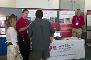 Representatives from Saint Mary's University describe their GIS degree options at the Academic GIS Program Fair. |
 More than 10,000 people attend the Esri International User Conference every summer. Your students will be the next generation of GIS professionals. |
San Diego also offers wonderful field experiences—the desert, coast, and chaparral and a lively downtown. The convention center looks out over one of the world's most beautiful natural settings—the San Diego Bay. GIS provides great tools for understanding and managing the world around us, but it will never replace the need for direct experience. Before, during, or after the conference, go outside and explore!