ArcWatch: Your e-Magazine for GIS News, Views, and Insights
May 2011
Building a Knowledge Infrastructure
As Seasoned Utility Staff Retire, Will They Take Wisdom with Them?
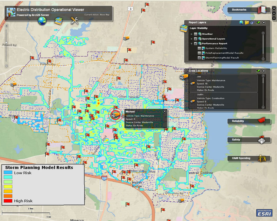
Electric utility operators monitor field crew activity along with weather and network performance using ArcGIS technology from Esri.
When I ran an electric utility operations division, one of my favorite employees was a guy named Stanley. Stanley started as a line worker, climbing poles, then became a foreman and a supervisor. Finally, Stanley managed all the crews in the region. I remember how Stanley worked.
In the northeastern United States, the hot, humid summer months present a particularly serious storm threat. The severity and location of the thunderstorms were never predictable. Since this part of the country is heavily treed and the vast majority of the distribution lines are overhead, one of these violent storms could cause significant damage to the electrical system, which in turn would result in many outages.
So, Stanley’s challenge was this: as the crews rolled back into the service center after a day’s work, Stanley had to decide whether to keep workers on overtime in case trouble hit or send them home and hope nothing bad would happen.
Stanley had a routine. He would carefully check the latest weather forecast to see where a storm was likely to hit. He also knew which areas of the system were more vulnerable than others. He listened to his crew chiefs telling him where poles were leaning and wires were frayed. He knew where trees hadn’t been trimmed in a while and where the fussy customers lived. Stanley then stood outside and smelled the air. After his routine, which only took a few minutes, he would walk back into his office and call the union steward and tell him exactly how many crews to keep on overtime. If Stanley kept too many crews and nothing happened, he would have wasted overtime money and be shorthanded in the morning. If he kept too few workers, or none at all, and something bad happened, he’d have to scramble to get people back to work, which was difficult and sometimes even dangerous. Yet in all the years I knew Stanley, he rarely made the wrong decision.
Then Stanley retired.
Thousands of workers like Stanley will leave the industry over the next several years. The average age of US utility workers is nearly 50, and more than 148,000 utility employees fall in the 55- to 64-year-old range, with another 26,000 employees over age 65, according to the Bureau of Labor Statistics. The National Rural Electric Cooperative Association (NRECA) published a recent study that showed that 61 percent of line superintendents are age 50 or older.
Imagine all the wisdom and analytic power that will be missing when these workers retire.
People like Stanley know where infrastructure problems exist. They know where the utility has not trimmed trees. They know the location of old and frayed wires that are just waiting to fall down. They remember where storms generally hit and the problems that storms cause.
What many utilities are missing is an ability to capture as much of that wisdom as possible before the Stanleys of the industry retire.
What they need is a way to share what retiring workers know and how they know it.
The Need to Capture Information
GIS-based modeling for storm preparation helps utilities identify vulnerabilities.
The common denominator of that knowledge is location. Utilities have been capturing facts in geographic information systems for years.
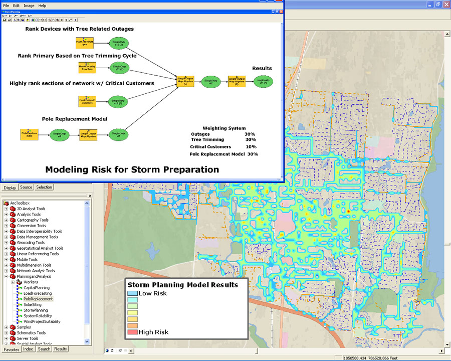
Today, GIS can capture observations and predictive information, collect data from all kinds of sources, and help utility staff make better risk predictions the way Stanley did. GIS can create geoprocessing models that document the data sources, run analyses, and produce results in the form of a map.
The key is to have these models validated and supplemented by experienced workers before they leave, so that utilities can truly build a knowledge infrastructure.
Victoria Morrow, GIS manager for Broward County Government in Florida, believes knowledge retention is important for all aspects of government. “How do we capture the years and years of experience in emergency operations, traffic management, 911, and elections before these experienced workers retire?” Morrow asked. “As GIS manager of a large metropolitan county, I see this issue across almost all departments. It is even more pronounced in those agencies that have only just begun to embrace GIS technology.”
As rightly noted, the concern is shared by any department that collects and stores data.
This institutional data is a must in almost every industry. We acknowledge a need for it, but what can organizations do to get the data that is stored in the heads of seasoned workers?
Collecting Subject Matter from SMEs
There are notable concerns that accompany the idea of moving information from the mind of a subject matter expert (SME) to a tangible, accessible database. How do we best approach the task? What questions do we need answered? How do we compile and utilize this information once we have it?
“One approach that we have used successfully is to gather some of the SMEs in a room,” said Ron Brush, president of New Century Software. “We have a meeting facilitator, a GIS analyst, and a system map on a big screen. We ask the SMEs to tell us about different parts of the system they know best. The analyst creates new features and feature classes—usually polygons—and captures the knowledge about that part of the system.”
SMEs can impart information related to known problem areas, installation methods and materials used, landowner information, and more. Each SME’s name as well as date and other metadata are attached. This information can then be vetted with other SMEs and later organized into a more usable format.
“The spatial SME approach will be important for gas distribution operators as they move forward with their Distribution Integrity Management Program [DIMP] planning and implementation,” Brush said. “While this approach may not replace Stanley’s ability to predict the weather, it can help retain valuable knowledge about utility assets that might otherwise be lost. Plus, I think it’s a compliment to the SMEs to acknowledge their experience and value to the organization.”
In the absence of SMEs, some industries are relying on historical incident data to fill knowledge gaps, according to Sentil Prakash Chinnachamy, GIS project coordinator/business development for Spatial Edge. “Institutional knowledge management is similar to metadata management—a challenging workflow in federal and private agencies, usually considered a time- and
resource-consuming process,” Chinnachamy said. “Combining old-school methods with the latest technologies could help. Imparting institutional knowledge collection in the data collection workflow is a way to go.” For companies that have not yet started data collection, Chinnachamy says it is better late than never.
“We have spoken of this concept in our shop as well, and I think it could be worthwhile to pursue,” said DeAnna Hohnhorst, GIS technician, Georgia Power. “As a GIS technician with skills in building geodatabases, spatial analysis, and modeling, I would be pleased to add this type of endeavor to my project list.”
Add It to the To-Do List
The idea of gathering experts in a room and drawing concerns on a map for entry into a GIS has significant value. By applying spatial analytics, we can combine SME data with authoritative data. This analysis connects the dots between what people know and what operations or historical data is stored in the system. Also, the visual presentation in a
GIS-based model-builder environment gives experienced workers the ability to investigate variables in something crucial such as risk assessment. Stanley might look at the model and say, for example, “You forgot to include soil types in the assessment, since trees fall over more easily in sandy soil than in clay.”
In this case, what Stanley is doing in his head is spatial analysis. He is taking data from
a variety of sources, merging that data with his own and coworkers’ experiences, and predicting where problems are most likely to occur. He then takes action to mitigate or at least prepare for the problems. When a storm hits and outages occur, Stanley is never very surprised. In fact, he has a restoration plan in his head, ready to go.
The common denominator of Stanley’s thinking is geographic location. Stanley connects the dots related to geography. The intersection of the many problems creates for him the areas of highest risk and vulnerability. If the storm strikes there, he is ready.

Bill Meehan is Esri's director of utility solutions
Most utilities have collected an enormous amount of data that can be used for spatial analysis within a GIS. While GIS has traditionally been used for making clearer maps of the electrical system, it now serves as a framework and foundation for the knowledge infrastructure.
For utilities, this knowledge infrastructure is as much an asset as the actual pipes, wires, and hardware of the electrical or gas system. The more knowledge that a utility has about its assets, employee experiences, customer behavior, and the world around them, the better decisions management will make.