ArcWatch: Your e-Magazine for GIS News, Views, and Insights
May 2011
Mapping an Arctic Adventure
Esri UK Ltd. Creates Online Map to Track a Trek to the North Pole by Wounded Soldiers
This interactive map created by Esri UK Ltd. shows the route the Walking with the Wounded team took to the North Pole.
When Arctic explorers Fridtjof Nansen and Hjalmar Johansen left the ship Fram in 1895 to try and reach the North Pole using sled dogs, no one heard from them for more than a year. Their friends, relatives, and shipmates could only guess where they were on the map.
But when seven men recently braved treacherous ice ridges, dangerous fjords, and bitter subzero temperatures to reach the geographic North Pole, people around the world were able to follow along online using an interactive map created by Esri UK Ltd.
The seven, including four wounded ex-servicemen from the United Kingdom, triumphantly arrived at 90 degrees north on April 16, 2011, completing a 13-day, 200-mile trek across the frozen Arctic. Their Walking with the Wounded (WWTW) charity organization’s expedition made history, as the team included two men who became the first amputees to reach the North Pole unaided.
Britain's Prince Harry, the expedition's patron, joined them for the first three days of the Arctic adventure, which raised money for educational training, therapy, and other support for British service members who return home from war injured or traumatized.
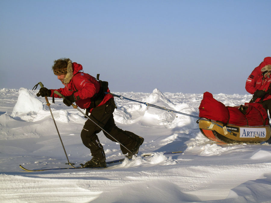
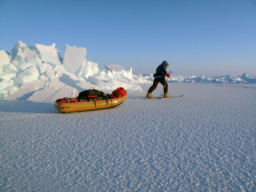
The 13-day trek to the North Pole took strength and endurance.
Photo courtesy of Walking with the Wounded.
People in the United Kingdom and elsewhere kept up with the trek via the WWTW website, with its interactive map and a blog that included the latest photos and audio from the modern-day polar explorers. The map displayed the men's location based on GPS coordinates relayed back to WWTW headquarters.
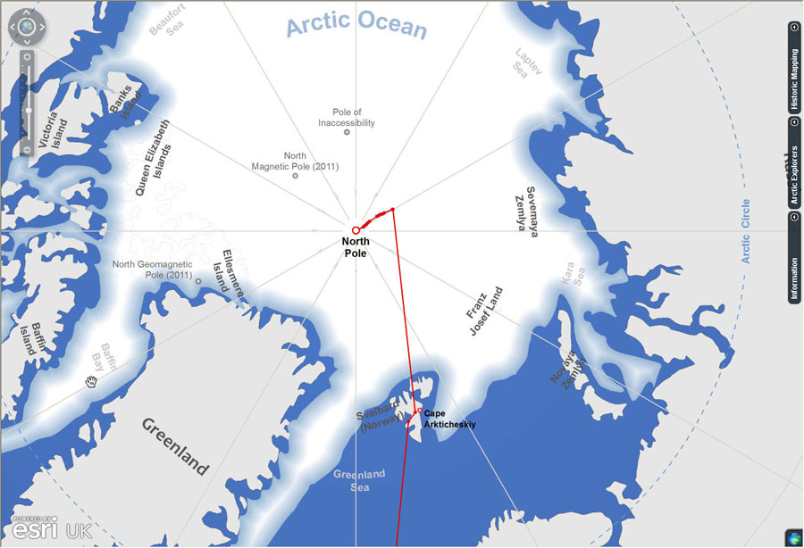
Esri UK’s interactive map covered the Arctic region. It highlighted key points of interest and let visitors follow the expedition's progress in near real time. The route stretched from London to Longyearbyen, Norway, where the team was initially delayed for several days due to bad weather. The explorers took a plane north on April 4, crossing the icescape to Camp Barneo, a Russian ice base, then to 87 degrees north, where the men, by now in a helicopter, landed and officially began the trek. Bundled in red, heavily insulated jackets and pants, they strapped on skis and headed off into the wilderness of snow and ice.
In a statement on the WWTW website, Prince Harry summed up why he supported the venture.
"This extraordinary expedition [raises] awareness of the debt that this country owes to those it sends off to fight—only for them to return wounded and scarred, physically and emotionally.…This polar adventure [exemplifies] the tenacity and remarkable courage of those who serve in uniform."
The Online Map’s Design and Development
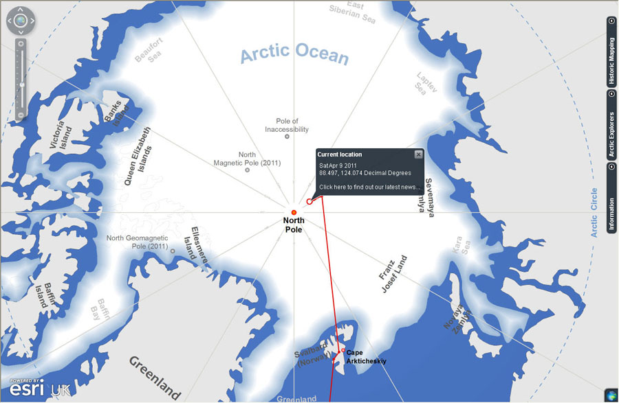
People kept tabs on the current location of the Walking with the Wounded team using the online map.
Developed using ArcGIS Server, Esri UK’s interactive mapping application combined the WWTW team's expedition route with historic information provided by the Royal Geographical Society (RGS). The route of previous expeditions, along with historic maps and charts, could be examined online, in many cases for the first time.
Users could navigate across the Arctic region and explore for themselves places such as the Beaufort Sea, the Queen Elizabeth Islands, Franz Josef Land and the Kara Sea. Visitors could also read stories about early famous polar expeditions such as those of Robert Peary, Sir William Edward Parry, Roald Amundsen, and Sir Walter William Herbert. Though Peary was for many years credited with the feat of being the first to reach the North Pole, today that claim is often doubted.
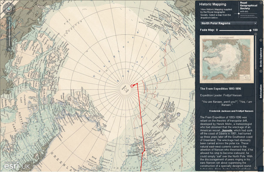
Using Esri UK's interactive map, visitors could call up interesting stories about historic polar expeditions. One such journey was the attempt by Norwegian explorer Fridtjof Nansen to reach the North Pole in the ship Fram.
Peter Wilkinson, head of the Esri UK Technical Solutions Group, led a two-person team that designed and developed the web map viewer and widgets for WWTW. He said that adding the routes and stories of those explorers, along with historic maps and charts of the Arctic, added an educational element to the mapping application to create more interest for schoolchildren, teenagers, and adults alike.
For example, they could read about the fascinating expedition launched by Nansen in 1893 to reach the North Pole aboard the ship Fram. His idea was to let the ship become icebound so the ice pack, which shifts due to Arctic Ocean currents, would carry it to the pole. Though it missed its mark, the ship (and crew) emerged essentially unscathed from the ice and into open water in 1896. In 1895, Nansen and Johansen left the ship and, using a dog team, tried to reach the pole. They failed in the attempt, retreated, and were then rescued about a year later in Franz Josef Land, an archipelago north of Russia.
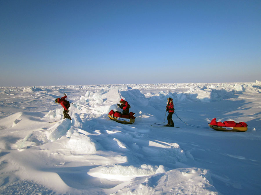
A team member skis north past an ice pressure ridge.
Photo courtesy of Walking with the Wounded.
"We wanted to create a more engaging site to help people learn more about the Arctic," Wilkinson said. "We want people to see that the Walking with the Wounded team members are following in the footsteps of some incredibly notable Arctic explorers."
Watch this video, which includes an interview with Wilkinson, to learn more about the creation of the online map.
The RGS archives supplied historic maps, charts, stories, and photographs of six explorers, whose attempts to reach the North Pole dated from the early 1800s to the late 1960s. Esri UK worked with maps and charts scanned from the original documents in the RGS archives. "Being mapping enthusiasts, it was quite an honor to be able to work with the original maps and bring them to life with our interactive map," Wilkinson said.
Esri's ArcGIS Desktop 10 was used for creating the map (MXD) documents, cartography, and data management. Wilkinson said there were a number of challenges, including sourcing up-to-date information for the Arctic region, such as the latest sea ice extents, and working in unfamiliar polar projections.
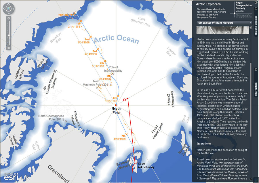
This historic map from the Royal Geographic Society shows the route Sir Walter William Herbert took to the North Pole.
"We were particularly keen to create a good-looking basemap that could form the basis of the website," he said. "We used a number of the cartography tools to help us get the basemap just right.”
The online mapping application was built using Esri's ArcGIS Viewer for Flex 2.2, a ready-to-deploy viewer that is configurable for adding additional tools and data content. The Esri UK technical team developed additional Flex widgets such as pop-up dialogs, fader bars, and an administration console that the WWTW staff used to update the expedition team's route on the map.
Wilkinson said that when the men's coordinates were relayed back to Britain from the Arctic, the WWTW support team added the latitude and longitude to the administration console. The points were stored in the geodatabase and displayed dynamically on the map, with a line drawn back to the last recorded location, thus creating a route. "When a [map] user clicked a specific point on the route, it displayed an information window that showed the location and date and provided a link to the relevant WWTW blog post," he said.
The skiers, who spent about nine hours a day trekking, encountered a winter wonderland.
Photo courtesy of Walking with the Wounded.
ArcGIS API for JavaScript (Compact Build) 2.2 was used to create an application that replicated the functionally of the embedded WWTW map viewer. "This allowed the map to be accessed from a mobile device [such as Apple's iPhone or iPad] or other environments where the Flex plug-in is not supported," Wilkinson said.
The WWTW expedition generated worldwide media attention, especially since Prince Harry lent his support by skiing part of the way with the WWTW team. To handle a potentially high number of views on the mapping application site, Esri UK decided to use ArcGIS Server running on Amazon's Elastic Compute Cloud (EC2).
In this ArcWatch article The New Age of Cloud Computing and GIS, author Victoria Kouyoumjian wrote that one of the critical differences between traditional and cloud computing is the scalable and elastic nature cloud computing provides. This offers cloud consumers reliable and quick response times and the flexibility to handle traffic fluctuations and demand.
Wilkinson said that creating the mapping application for the WWTW expedition was "a fascinating learning experience," in part because the project demanded using unfamiliar datasets from Canada, Russia, Norway, and the United States. Also there were challenges associated with what Wilkinson called the peculiarities in the projections used to create maps of the Polar regions—mapping out an area of the world from the top down rather than traditional map development undertaken by viewing the globe laterally from left to right. "But it wasn't just a challenging project; it was also extremely fulfilling, in that we knew our interactive mapping application was supporting a unique expedition led by an incredibly brave team of soldiers," he said.
North Pole the Goal
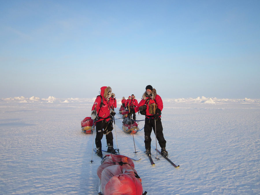
The team closes in on the North Pole.
Photo courtesy of Walking with the Wounded.
WWTW was founded by Simon Daglish and Edward Parker. Parker's nephew was seriously injured in Helmand Province in Afghanistan in 2009, inspiring Parker and Daglish to set up the charity organization. The charity aims to raise 2 million British pounds (US$3.2 million) to fund job training and recovery programs for wounded service members.
Besides being a fund-raiser, the WWTW expedition was meant to spotlight the strength, endurance, and determination of soldiers who have overcome what may seem like insurmountable obstacles to achieve such a major physical feat as reaching the North Pole.
The team included Martin Hewitt, whose right arm was paralyzed after he was shot; Steve Young, who suffered a fractured vertebra and other injuries after an improvised explosive device (IED) hit his vehicle; Guy Disney, who lost his right leg below the knee after a grenade attack; and Jaco Van Gass, who lost his left arm after he was struck by a rocket-propelled grenade. Daglish and Parker also joined the expedition, which was led by polar guide Inge Solheim.
Richard Waite, managing director for Esri UK, said the company was honored to create the online mapping viewer to keep people apprised of the trek's progress. "We were extremely proud to support such an inspirational expedition," Waite said. "The incredibly brave individuals who took part not only raised much needed funds but also proved that disability is no barrier to endeavor and achievement."