ArcWatch: GIS News, Views, and Insights
May 2012
Qatar Implements Geocentric Budgetary System to Simplify Project Approval Process
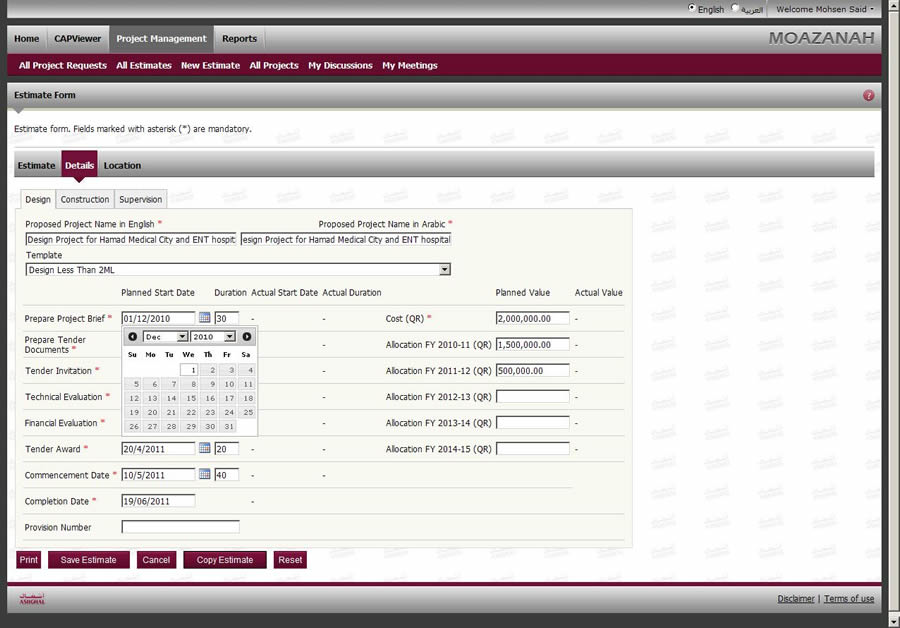
The Project Management view shows a high-level project estimate for a medical facility.
GIS technology from Esri is being used to track infrastructure project locations in the State of Qatar, a Middle East nation on the Persian Gulf.
Qatar implemented a nationwide geographic information system based on Esri's ArcGIS more than 15 years ago. Since that time, it has continued to expand its use of geospatial technology.
The country's public works authority recently implemented Moazanah, an infrastructure management system that uses ArcGIS technology to track project locations, which reduces construction costs and disruption to local businesses and residents.
"Moazanah manages our government infrastructure projects from beginning to end," said Nasser Ali Al Mawlawi, an engineer and the president of Ashghal, the Qatar public works authority. "It has not only expedited the review and approval process, but we [also] are already seeing a cost savings, which will undoubtedly result in a significant return on investment."
Boom in Population and Infrastructure
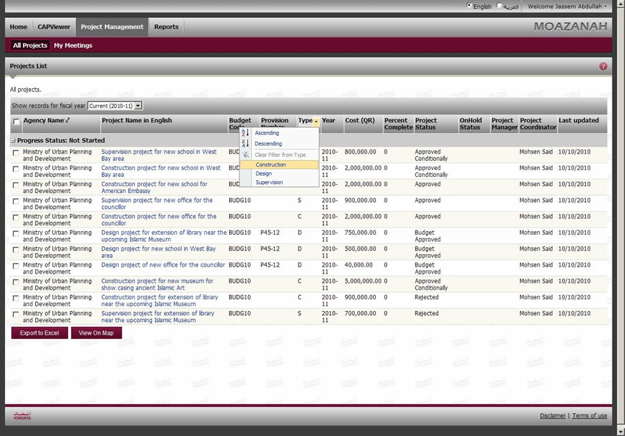
This map view displays a list of all projects so they can be reviewed by the project coordinator.
With its wealth in oil and natural gas reserves, resulting in an expansion of trade and investment, Qatar's population has more than tripled to 1.7 million since the 1990s. This population growth has sparked an unprecedented boom in construction and infrastructure development projects.
Ashghal is responsible for a significant amount of the country's infrastructure, including roads, wastewater systems, and public buildings. But many other government organizations also are in charge of designing, building, and maintaining government facilities. Because all government infrastructure projects compete for public funding, Ashghal was assigned to implement a system to coordinate the annual capital project budget application process.
Traditional Budget Process Led to Errors and Delays
Historically, the budget application process for major infrastructure projects was primarily paper based. This often led to paperwork being incomplete and lost, resulting in protracted meetings between the ministries and Ashghal to resolve conflicts and miscommunications, as well as late project submissions and frequent submission deadline extensions. That led to limited opportunities to collaborate on projects and complicated the tracking process.

This map view shows proposed projects with attribute details.
To automate this antiquated process, Ashghal's Engineering Business Services Department defined the requirements for a capital project request management system, Moazanah (Arabic for "budget"), to facilitate the country's budgetary review and approval process. Moazanah's overarching aim is to make sure that all capital project funding applications move forward smoothly and with greater clarity for the agencies and individuals involved in the review process. The Moazanah project was ultimately awarded to Rolta Middle East, an Esri partner.
GIS-Based System Resolves Budget Process Bottlenecks
On the surface, a capital budget review process—with its mix of estimates and textual details covering legalities, materials, construction services, and logistics—may seem to lack geographic content.
Georeferencing, however, is central to Moazanah. Each project has a geographic extent, drawing attention to any overlapping neighboring project. Each overlap becomes an opportunity for coordination and cost savings.
For example, it is obviously costly and inefficient to repeat construction work on a stretch of roadway. However, in the past, projects were proposed, funded, and completed without consideration for other projects that involved tearing up the same stretch of road that had just been resurfaced. These repeated disruptions cost the government money and unnecessarily impacted local businesses and impeded traffic flow throughout the affected area.
Using Esri's ArcGIS technology—a key component within Moazanah—to track project locations helps coordinate neighboring or associated work, which reduces construction costs and disruption to local businesses and residents.
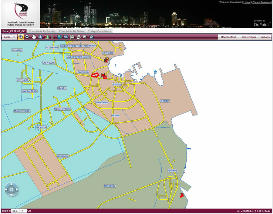
This is a high-level map view of multiple projects being proposed.
Central to the Moazanah solution is Rolta's OnPoint, a web-based GIS application; SharePoint Web Parts; and Microsoft SQL Server. Esri's ArcGIS for Server manages the spatial data for subsequent analysis and distribution. Moazanah is also integrated with Primavera's Project Portfolio Management (PPM) to organize and manage the proposed projects once the budget is approved.
System Is Simple to Use
The system features a series of interconnected SharePoint forms that are specific to the role of the individual who logs in. Because ease of use was of utmost importance to Moazanah's successful deployment, the user interface was deliberately kept clean and intuitive.
"We recognized early on that Ashghal had very ambitious plans for this system," said Shafik Jiwani, executive vice president of global business development at Rolta. "With over 23 agencies involved in the process, hundreds of users, and hundreds of projects filled with numerous details, it was quite a challenge to present it all in a way that felt intuitive to the user. As tempting as it was to build a sophisticated interface with lots of complex tools, the smart approach was to keep the interface clean and simple. It had to be easy to find needed information to make informed assessments and immediate decisions."
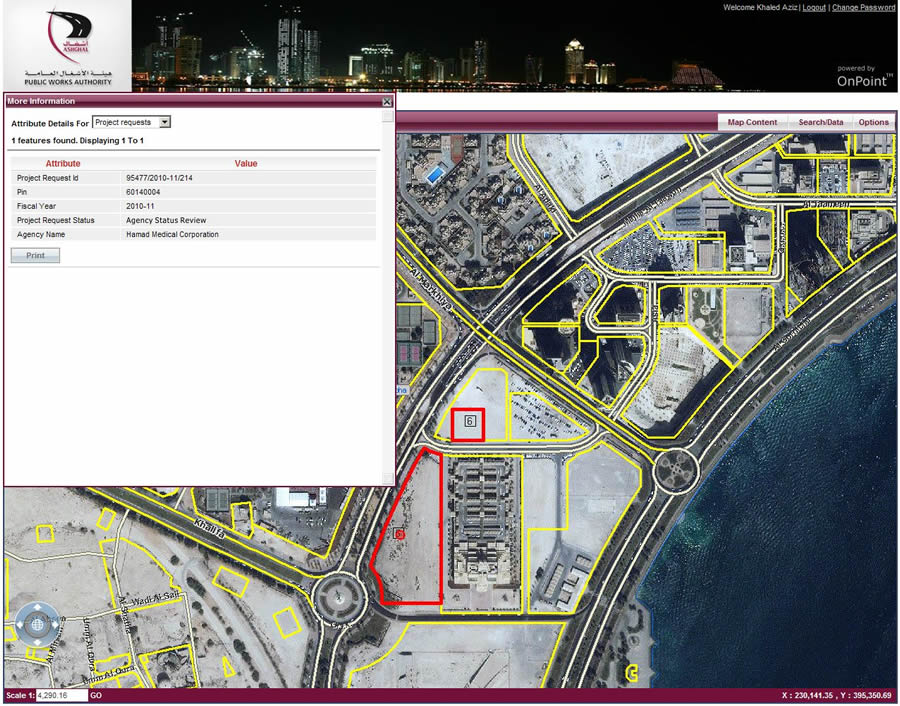
These attribute details and map view show an agency's proposed project that is spread over two parcels.
Key performance indicators (KPI) are extracted from the data and displayed on a dashboard customized for a department head's interests and responsibilities. Moazanah is used throughout the project assessment process to evaluate a proposed project's suitability and impact on its specified location. During this process, various location-based government regulations, such as zoning, must be considered. GIS is also used to drive other geospatially based analyses, such as the number of project requests submitted within a particular municipality and the status of projects.
New System Increases Efficiency and Facilitates Collaboration
Moazanah has made Qatar's budgetary process more efficient by allowing required information to be submitted and examined digitally. All stakeholders can evaluate and discuss the same information as it proceeds through the review procedures, facilitating collaboration and coordination. Qatar now has an immediate status report for all proposed projects in the country.
"Moazanah provides us with a forum to discuss and analyze the country's infrastructure project proposals so that we can confidently move forward with them, knowing they are properly managed and within budget," said Abdussamad Mohamed Al Makei, Ashghal's manager of the Engineering Business Services Department.