Nashua, New Hampshire, Automates Earth Day with Digital Pen-and-Paper Software and GIS
On Earth Day in April, cities across the country and citizen volunteers join forces to focus on a common cause: cleaning up communities and educating others about recycling, renewable energy, and other ways to protect the environment. In many communities, that often means getting out, leaving technology behind, and going back to basics.
 After GIS data is collected from paper maps using the digital pen and paper solution, it's uploaded via computer into Esri's ArcGIS software. |
Like other municipalities, the city of Nashua, New Hampshire, uses sophisticated technology for efficient governmental planning and to offer residents public services. But Nashua also relies on technology to plan for Earth Day—an important celebration for a city that Money magazine has named one of the best places to live in the United States.
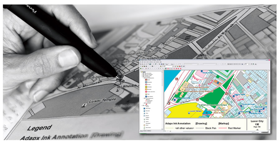
This year, the city of Nashua brought its sophisticated GIS mapping system out of the office to turn untrained Earth Day volunteers into GIS analysts. They worked with Capturx for ArcGIS Desktop, digital pen-and-paper collaboration software from Seattle-based Adapx. The software lets users of Esri ArcGIS Desktop software collect GIS data with a digital pen and paper. They use the pen to make field annotations on paper maps and then upload that information, via computer, directly into Esri's ArcGIS software. The digital pen stores data and, once docked in its station, transforms it into geodatabase features. This makes handwritten GIS information instantly available in a digital format and ready to share.
Trading Traditional Paper Maps for a Digital Solution
Community leaders and city planning department employees coordinated a broad range of Earth Day activities across the region. They planned to disperse teams of volunteers with supplies to clean and spruce up the environment, including a project that would involve removing trash, old tires, and rusted vehicles from 233-acre Southwest Park. To prepare, city planners spent a lot of time collaborating over maps to figure out who would go where and what resources they would need. Nashua traditionally hosts a series of multidepartmental meetings to outline Earth Day plans with key city stakeholders including staff from the Streets and Roads, Public Works, and Parks departments; educators from local schools; and volunteers. The planning began in late winter for the citywide spring celebration. The city needed to create a joint plan of action to delineate specific zones of activity for different types of cleanup and resource allocation.
In the past, teams would print out special GIS maps from the city's database with appropriate information highlighted about public parks, roads, and facilities. Leaders would huddle around these maps and mark who should go where. While individual planning sessions could happen relatively quickly, gathering all the paper plans and drawings on maps and processing the data into a cohesive plan often took days or weeks. Entering the information into GIS systems was important for sharing the data with others and documenting plans for future events.
Angelo Marino, Nashua's chief assessor and GIS coordinator, took a different approach this year. The stakeholders again worked with large maps on ordinary paper, but this time the maps were produced with Capturx for ArcGIS. The software enables data from ArcGIS to be printed on ordinary paper with a special digital watermark that is readable by digital pens. Each printed map includes a unique pattern of imperceptible dots that are linked to the underlying GIS data. The printed map can be marked up with ink, the same way that teams use maps today for inspections, surveys, and more. In addition to ink, the digital pen also has an infrared sensor, processor, and memory. As the pen writes, the handwriting is digitized and stored on the pen. When the pen is docked to a PC, the data is uploaded and integrated directly into ArcGIS.
The Earth Day planning team members marked up their printouts with the digital pen, which digitized the notes as the teams wrote their plans. When the session was over, they still had physical maps that were marked with ink, but they also had the data stored in all the pens. Marino simply collected the pens and connected them to his computer. The information was instantly merged into ArcGIS and entered in the geodatabase without any manual retyping. Marino then created PDF files with consolidated plans and maps and e-mailed them to all the stakeholders. Within five minutes of the conclusion of the meeting, everyone who attended had the full Earth Day planning details, cleanup zones, and full resource allocation requirements.
In the past, the time lag between GIS-level data collection, system entry into Esri's ArcGIS Desktop ArcMap application, decision making, and distribution of the results took days or weeks. Committee members would wait for meeting notes to be entered, compiled, and re-sent to the broader committee so they could finalize their planning. This time, the teams quickly refined their plans for Earth Day while also saving a lot of effort to rekey and interpret all the markups on the maps.
But that wasn't the end of the use of digital pens for Earth Day in the Nashua area.
Planning a Park Cleanup
A local teacher was working with the University of New Hampshire Extension on a park project to help map trails and collect garbage for Earth Day. She enlisted a local mountain bike club and volunteers to spread across Southwest Park with GPS units. The Capturx digital pen was used to designate and mark on a printed map four different work zones to which the volunteers would be assigned. "Within 10 minutes of docking the pen, we were able to e-mail the modified map with the zones and text to the group," said Marino.
The volunteer teams received specific instructions as to the location of trash collection points. The city's parks and recreation supervisor also used the pen to designate the locations on the map where they would be placing dumpsters, parking trucks, and collecting trash bags. Once all the data was imported, the final maps were printed by the supervisor and handed out to his staff. The volunteers were also able to use the digital pens to note on the maps the location of large trash items, such as discarded appliances, so that crews from the sanitation team could find these items in often remote parts of the park.
The second part of the team's mission was to accurately capture trail routes throughout the park. The Parks Department wanted accurate data on how people use them, so they could keep people on these paths and avoid trampling off-trail areas by providing large maps in conveniently located kiosks within the park.
The student volunteers traveled the trails with GPS units, which collected their paths and coordinates. This raw data looked good when overlaid on the park map in the computer GIS system from a distance. However, as the team began zooming in to the data for its eventual use on a large printed map, the meandering of the students created very erratic tracks. Marino used the digital pen to trace the path of the tracks in a continuous motion, so the city now has a very smooth GIS layer in their geodatabase to produce park trail maps.