Web GIS Aids Groundbreaking "Preschool for All" Program
By Lorne Leonard, Bernard Cesarone, and Atakan Guven
 The Illinois Early Childhood Asset Map (IECAM) shows the diverse mix of early childhood education programs and providers, giving policymakers and the public an overview of what's available and where. |
Young people benefit greatly from high-quality early education, a fact that prompted the State of Illinois to enact Preschool for All (PFA) legislation two years ago. Signed into law by governor Rod R. Blagojevich, PFA aims to make preschool available for all the state's three- and four-year-olds by 2011.
To help agencies equitably plan services and allocate monies for PFA based on where needs are greatest, the Illinois Early Learning Council requested the creation of an interactive, Web-based tool to compile the relevant data on early care and education services. The result: the Illinois Early Childhood Asset Map (IECAM), a GIS Web application developed by the Early Childhood and Parenting (ECAP) Collaborative and the National Center for Supercomputing Applications (NCSA) at the University of Illinois, Urbana-Champaign (UIUC). ECAP worked on the project with Chicago Metropolis 2020, a business-backed civic organization.
IECAM's developers believe this project is the first of its kind in which a state seeks to coordinate data on all its early-childhood care and education services. As such, IECAM may serve as a model for other states as education officials attempt to improve the provision of these services for preschoolers.
IECAM (visit http://iecam.crc.uiuc.edu/), powered by Esri's ArcGIS Server, combines data on early-childhood care and education services, such as Head Start and prekindergarten programs, with demographic data about children including population, the numbers of children at various percentages of the federal poverty level, and the linguistic isolation of Spanish- and other non-English-speaking households. People using the IECAM Web site can search for and produce digital maps that display the location of prekindergarten educational services by county, township, municipality, ZIP Code, legislative districts, and Illinois State Board of Education (ISBE) and Illinois Department of Human Services (IDHS) regions. The online site also contains the demographic data, providing comprehensive information that will let decision makers see where more PFA sites and monies might be needed. The site could also be used, for example, to identify areas with high Latino populations (as shown on the demographic theme map) where more Spanish-speaking instructors will need to be recruited.
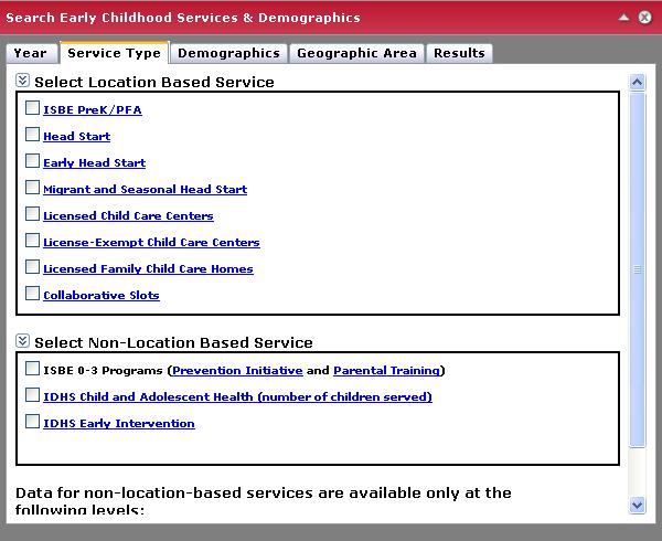 IECAM's Search Early Childhood Services and Demographics Tool allows users to select from a variety of early childhood services, demographics, and geographic areas. |
"IECAM pulls together a wealth of important early childhood program and demographic information—the kind of numbers sought by children's advocates and policy makers alike," said Sean Noble, director of government relations at Voices for Illinois Children.
"This significant new data tool will help us to get a better grasp on the real, ground-level implications of statewide policy decisions regarding early education as well as assist in improving those decisions. Its micro-level focus will greatly benefit macro-level policy approaches to match the needs of kids and families with the availability of different kinds of early learning programs."
Accurate Data Needed for Planning Purposes
The State of Illinois has increased funding for early-childhood education by more than $163 million since 2003. State officials, the business community, children's advocates, and legislators all agree that decisions about resource allocation must be based on transparent and accurate data. That's why the Illinois Early Learning Council called for the creation of IECAM, which makes that data readily available and promotes its use in decision making. Data for the IECAM project comes from ISBE and IDHS as well as from other sources such as the Illinois Head Start Association and the Illinois Network of Child Care Resource and Referral Agencies. The demographic data related to population, federal poverty levels, and language use was combined with the early-childhood care and education data at various spatial regions such as Illinois legislative districts, counties, and townships. Last year, this data-collection process resulted in approximately 60,000 geocoded locations of early-childhood care and education sites. IECAM's primary purpose is to help policy makers, legislators, children's advocates, child care administrators, and others better understand and improve early-childhood care and education services in the state. IECAM is not intended for parents to locate child care facilities; that service is provided by other organizations.
ArcGIS Server Used for Map Application
 In this example, a user has selected House District Senators within the Chicago area using the Search Early Childhood Services and Demographics Tool. |
ECAP and its partners have been collecting and preparing data for IECAM since 2005. Early case studies showed that users wanted to do more with the data than just download a spreadsheet. They expected to be able to use a map to search for geographic areas of interest, visualize locations in a wider context, and scrutinize information about early-childhood care and education sites. IECAM data was presented in tabular format only beginning in the summer of 2006. The GIS component of the IECAM Web site became publicly available last fall. GIS data geocoding and aggregation were completed by using Esri's ArcGIS Business Analyst software. The GIS application required about a year of part-time work to complete. It uses Esri's ArcGIS Server for the map application and Microsoft SQL Server for the database. Three versions of the application were developed, each scrutinized by the project's partners and potential user groups. These case studies indicated users' desire for simple and easy-to-use tools to find data. The applications were written using the C# programming language and took advantage of Esri's task framework to provide simple and effective tools for users. The latest version of the application has four unique tasks: (1) Search Early Childhood Services and Demographics, (2) Find Early Childhood Sites within radius, (3) Find Early Childhood Sites within boundaries, and (4) Create Standard Reports.
The Search Early Childhood Services and Demographics task allows users to choose from a variety of services, demographics, and geographic areas. This task is divided into five components. First, users choose the year of data they are interested in. Next, they choose the type of services available in that year. These are divided into location- and non-location-based services. The former are services (for example, Head Start) that are offered at an identifiable location that can be geocoded. The third component is demographic data. Users can select data related to population, several federal poverty levels, or language use. University of Illinois demographers calculated the 2005 demographic estimate data. The fourth component allows users to select from a variety of geographic areas. The last component shows the search results in a tabular format that users can export to a PDF or Excel file.
 Someone interested in finding early childcare centers can use this tool to find sites from a variety of geographic areas. |
It is hoped that visitors to the Web site will work with the search result data and the map together. Pending new census data and further usability studies, plans exist to refine this task to foster that type of interaction between data and map so the search results would be mapped.
The second task helps users find services within a small refined area of interest. This task, implemented using Esri's geoprocessing services, allows users to define a point on the map, choose an early-childhood care and education service type, and select a search radius. The search results include all the services meeting the chosen criteria within the selected radius. This tool helps administrators answer questions such as, Where are the child care centers nearest to this location? and How many children are being served within 10 miles of this location?
The third task allows users to easily find all the services within a predefined geographic area. For example, this tool is designed to fulfill requests such as, Show me all the child care locations within my municipality (or county or ZIP Code).
The last task generates standard reports that answer frequently asked questions. In standard reports, users combine a geographic location with the typical question. For example, ISBE requires new applicants for its PFA program to provide, in their proposal, information on early-childhood care and education availability in their area. Using the IECAM Create Standard Reports task, applicants can click on the task, choose the type of report they need, and select their geographic area. IECAM returns either a PDF or Excel file in response to their query.
 With IECAM, users can find early childhood services within a radius or buffer zone. |
In the future, IECAM will provide additional standard reports such as a report on publicly funded preschool programs. IECAM will also provide data for additional geographic regions such as school districts. Another major addition will be a multiyear feature with which IECAM can show both 2007 and 2008 datasets for analysis purposes. Using Esri's task framework and geoprocessing tools, IECAM's developers plan to implement tools that visualize analysis results between these two (and other) years so that users can find historical information about service availability. The goal is to keep the tasks easy to use while taking full advantage of Esri's rich architecture and geoprocessing power to support data management and decision-making processes. For more information and to test the application, visit http://iecam.crc.uiuc.edu/ and follow the links pointing to the GIS Web application.
Lorne Leonard is a GIS and research programmer with the Advanced Visualization Laboratory at the National Center for Supercomputing Applications with the University of Illinois, Urbana-Champaign. Contact him at leonard@ncsa.uiuc.edu.
Bernard Cesarone is the assistant director for technology in the Early Childhood and Parenting Collaborative, University of Illinois, Urbana-Champaign. He serves as the technology coordinator for the IECAM project. Reach him at cesarone@uiuc.edu.
Atakan Guven is the research and GIS analyst at Chicago Metropolis 2020, based in Chicago, Illinois. Contact him at atakan.guven@cm2020.org.