ArcGIS Explorer 900 Opens Up a New Frontier for Exploration
By Carla Wheeler, ArcWatch Editor
GIS for Everyone.
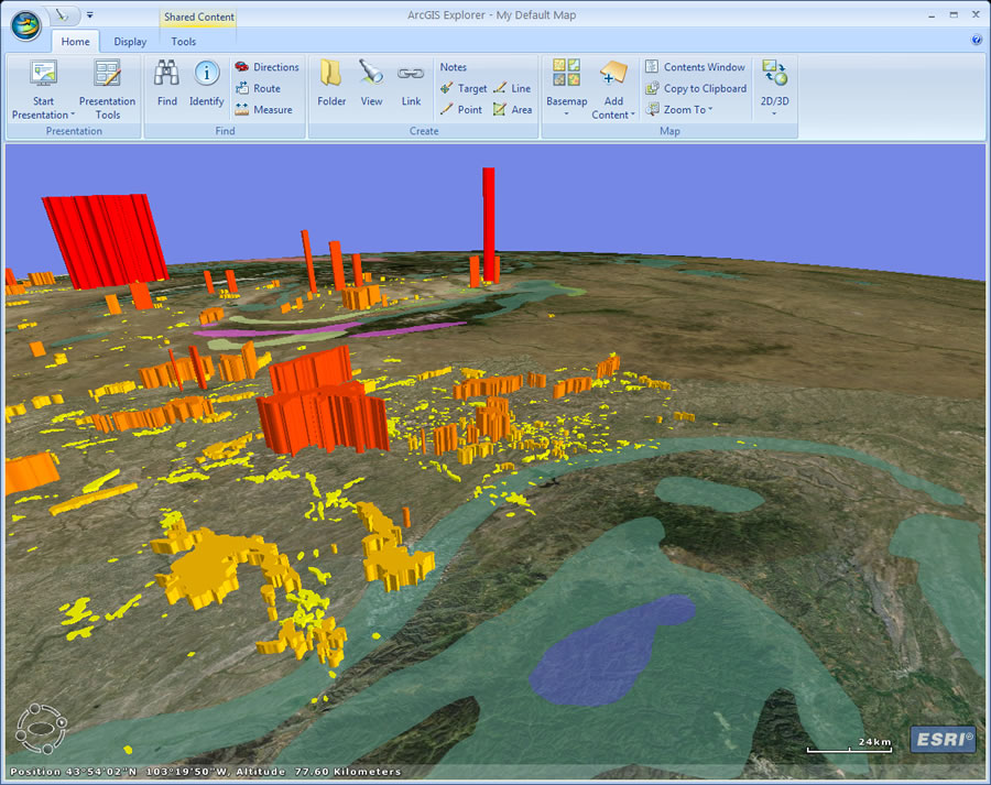 ArcGIS Explorer 900 will come with a new ribbon user interface. |
A bold claim, perhaps. But the release of ArcGIS Explorer 900 this summer will show how well Esri's free, downloadable software application lives up to that motto. The application includes a sleek new ribbon interface that lets you easily add content and basemaps, create presentations, and toggle between 2D and 3D map modes. These new tools and features will make displaying, visualizing, analyzing, and sharing geographic content and capabilities easier than ever.
ArcGIS Explorer 900 will succeed ArcGIS Explorer 500, and it's no coincidence that the gulf between the build numbers is so wide. "ArcGIS Explorer continues to evolve at a very rapid pace. We are just going to leap over all those numbers in the middle and go right to 900," Esri ArcGIS program manager Jim McKinney said at the 2009 Esri Developer Summit. "The capabilities of ArcGIS Explorer at 900 are truly innovative, exciting, and valuable to all of you."
After you download the application, you will find:
- A smart-looking and easy-to-navigate ribbon user interface (UI) with a lineup of tools to replace the application's former tasks. You can work with tools such as Find (symbolized with binoculars) to find locations on the map and zoom in, Link (with a chain-link icon) to add Web sites to your map, and Basemap (symbolized with four map images) to add a basemap from a selection provided by ArcGIS Online.
- Presentation tools for creating a dynamic, interactive slide show using your maps, data, and analyses, then sharing your work with colleagues. As you display each map during a presentation, ArcGIS Explorer will zoom to that location and remember settings such as which layers are on or whether pop-ups are open. You can also add titles and use other content such as photos and video.
- 2D and 3D modes. You will have the ability to toggle back and forth between 2D and 3D mode at the click of a button. In 2D mode, 3D features will drape over the map's surface, and in 3D mode, 3D features can be extruded.
- Default maps and an ArcGIS Online basemap gallery that includes imagery, transportation, political boundaries, streets, and Microsoft Virtual Earth maps such as aerial, hybrid, and streets.
- Support for ArcGIS Desktop layer files, along with the layer packages that were just introduced at ArcGIS 9.3.1. Layer files and packages allow ArcGIS Explorer users to leverage all the cartographic capabilities of ArcGIS Desktop.
- Direct connect to enterprise geodatabases, support for personal geodatabases, and improved support for KML/KMZ.
- Support for five languages other than English in the application and help, namely, Spanish, German, French, Japanese, and Chinese.
- Easy customization using configurations that let you control the look and feel of the application. At no cost, you can download an ArcGIS Explorer Software Developer Kit (SDK) that was redesigned for both .NET usability and the application's new functionality. Using the SDK, you can implement custom tools to meet your users' needs. You can create add-on tools, dockable windows, galleries, and more.
Perfect for Geographic Information Users
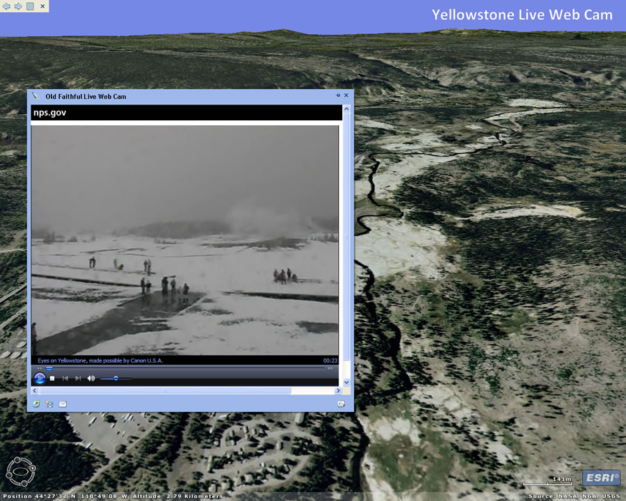 A link to a Web cam that shows Old Faithful erupting at Yellowstone National Park was embedded into a presentation created using ArcGIS Explorer 900. |
"ArcGIS Explorer 900 represents an evolution of the product based on user feedback and requirements since the application's first release in 2006," said ArcGIS Explorer product manager Bern Szukalski. ArcGIS Explorer team members have listened to what users have said about how they want to use the application and what kind of tools they need.
"This is the culmination of that really good feedback and all that we've learned throughout the first round of product releases," said Szukalski, adding that users want simple yet powerful ways to provide broad access to geographic content and GIS capabilities.
By design, ArcGIS Explorer 900 is easy to use. It is intended for not just GIS professionals, but also people Szukalski calls "GIS information users." Although GIS professionals who are used to doing more complex mapping tasks find innovative ways to use the application, ArcGIS Explorer increasingly fills a niche for these geographic information users.
"These are people with a strong need or desire to use geographic information, but they are not necessarily GIS analysts themselves," noted Szukalski. "They want to leverage GIS data and other geographic information in the context of a map, but they are not building or maintaining enterprise geodatabases or building geoprocessing tools." This type of person is likely a professional in his or her own field and, as such, needs to meld data, documents, and perhaps multimedia with a map.
"Good examples would be planners, wildlife biologists, or geologists," Szukalski said. "Here are domain experts who need to use GIS data and incorporate other things that they may collect or create-documents or photos or other things that gain additional value when placed in a geographic context." ArcGIS Explorer 900 will prove quite valuable to these professionals. "ArcGIS Explorer is really powerful because you can use GIS data directly and easily integrate other types of data," explained Szukalski. "This data could be in the form of reports, photos, videos, Web pages, connections to real-time sensors-you name it. Those gain added value by being placed in a geographic context."
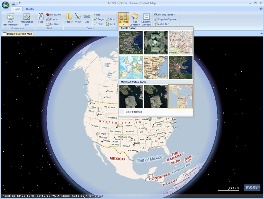 Switch basemaps easily using the basemap gallery. |
That's where the new ribbon user interface that runs along the top of the application becomes especially helpful. Szukalski said the streamlined user experience makes managing tools and content extremely easy. One of the great advantages is that only the tools you need to work with appear, making ArcGIS Explorer simple, easy, and intuitive.
Prepare Presentations Quickly
The presentation tools, which let you create a map-based dynamic presentation, grew out of the need for geographic information users to communicate geographically with government officials, the public, executives, or colleagues within their organization.
"A lot of people do that using PowerPoint, but we thought, wouldn't it be great if you could communicate in a geographic context using the same application and capabilities you use to create your map?" Szukalski said.
Click the Presentation tab, and buttons will appear below that will let you capture slides from the map you are displaying, remembering which layers are turned off or on or which pop-up windows or overlays are displayed. You can recapture them after you make any changes, edit the text that you want to add to the slides, delete or hide slides, add different fonts and colors, and create a slide presentation.
Although these initially seem like PowerPoint slides, Szukalski points out a key difference: the slides are not static. "You're actually using ArcGIS Explorer as the presentation technology so you can make your presentation interactive and include dynamic live content," he emphasized. "Creating a slide presentation with ArcGIS Explorer is simple and straightforward, taking only a few minutes to communicate geographically."
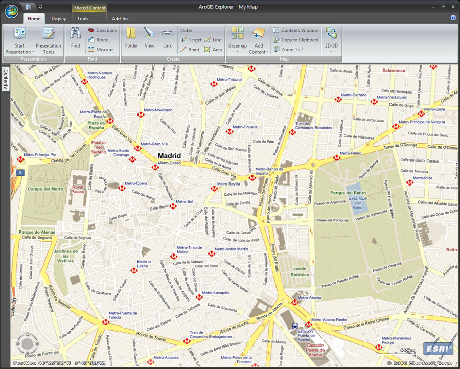 The streets of Madrid, Spain, provided by Microsoft Virtual Earth map services, are displayed in ArcGIS Explorer 900. |
ArcGIS Explorer also provides support for layer files and the new layer packages users can create in ArcGIS Desktop 9.3.1.
"What's really powerful about a layer package is it captures the cartography and the data in one compact, easily portable package," said Szukalski. "I can e-mail it, I can put it on a CD, I can share it on my network drives, or I can share it on ArcGIS Online to a broader audience." ArcGIS Online Sharing, available to Esri customers through their global accounts, will offer shared content along with imagery and data published by Esri and other users (A public beta will be released soon).
"We always had this concept that ArcGIS Explorer was a way to provide people with access to their GIS data and capabilities-that was always one of the basic, overarching tenets of the product," he asserted. "That still carries forward with ArcGIS Explorer 900. But there is a lot that we've learned in the details of what that really means, which makes ArcGIS Explorer 900 a much better tool for the more casual users but also for the GIS analysts and the GIS departments that want to provide broader access to their GIS content and capabilities."
Read more about what's new in ArcGIS Explorer 900. For tips and tricks on how to use the application, visit Szukalski's ArcGIS Explorer blog.