Think Localization
By Simon Thompson, Commercial Business Industry Solutions Director, Esri
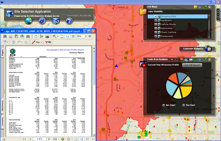 Esri GIS software and data provides in-depth knowledge to understand even small nuances among different neighborhoods. |
"Retail localization" is a phrase that is being bandied about more and more in commercial business. What exactly does it mean? If done correctly, retail localization means delivering the right type and volume of products or services to customers within a particular location by understanding the nuances of that area. This recently happened in Esri's hometown of Redlands, California, where the chamber of commerce used Esri software and data to provide demographic information about the surrounding communities that prompted the Dussin Group to open an Old Spaghetti Factory restaurant in a vacant building.
Markets vary by what is already available; what they can support economically; and the predominant "flavor," or lifestyle, of the area. GIS technology can be used to better understand the specific demographics and preferences in individual market areas by visualizing that data in an easy-to-understand format: a map. Instead of sifting through reams of tabular data, being able to see where particular types of people are located makes business decisions more accurate. GIS can be applied to retail localization in four areas of commercial business: real estate, merchandising, marketing, and the supply chain.
Localization, Not Just Location, Is No. 1 in Real Estate
Using GIS for retail localization positively affects commercial real estate by optimizing the placement of stores for the best market reach, helping evaluate sites, and improving market analysis. It is important to have the right type of operation in the correct location. Understanding the market means knowing whether an organization should enter, exit, or expand in it.
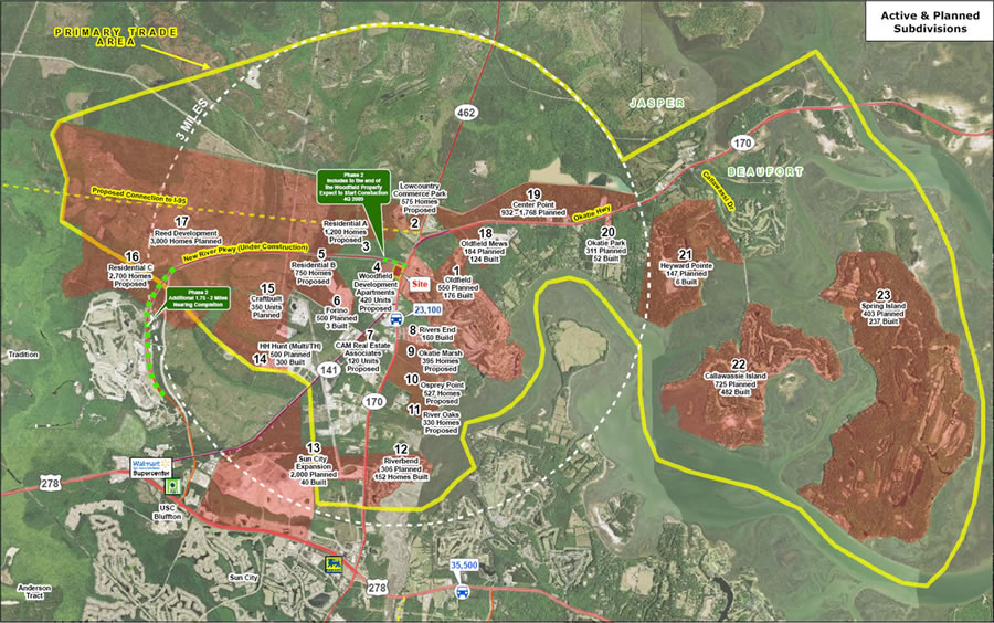 Edens & Avant can integrate their own data, city data, and national datasets to get a comprehensive understanding of the marketplace. |
Real estate is a no-brainer for GIS; looking at geography means looking at location. Viewing available sites, along with other information such as income, households, and supply and demand, gives the best overall view of the health of a particular market. A great example of this is Edens & Avant, an owner and developer of shopping centers on the East Coast. The company, headquartered in Columbia, South Carolina, helps clients such as Fresh Market, Whole Foods, Starbucks, and Target develop innovative shopping centers. The company uses GIS to look at existing population and demographic information for individual areas by displaying all the information clients need on a map. This makes decision making an easy-to-understand, comprehensive process.
One project, a 61,725-square-foot shopping center development, went forward only because Edens & Avant was able to determine that a large residential base was already in place to support it. Using GIS to analyze demographic information, the company found that the population in targeted areas had grown by 50 percent over the past decade. As a result, the new center was leased and opened on time. David Beitz, an executive with Edens & Avant, explained to me that without the information to support this decision and an appropriate way to communicate it, the project wouldn't have been as successful.
Customers Are Their Locations
Merchandising is another area where GIS can assist in localizing business—and not just for retail operations. Banks need to understand the loan products they are selling to customers. Realtors need to match the needs of home shoppers to the available housing inventory in an area. Insurers need to understand what risks are in an area to create the best policies. If a company does this correctly by understanding the profile of the people in an area and what their needs are, demand can be met. This is achieved by understanding the demographic makeup of an area; you aren't necessarily going to sell a house with a pool to someone who doesn't like to swim.
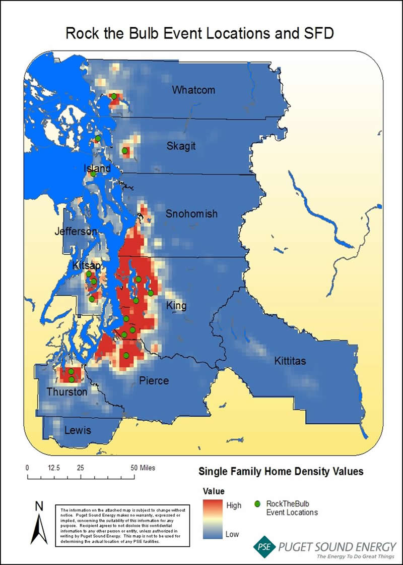 Puget Sound Energy uses GIS to help reach the right customers with marketing programs. |
One major manufacturer does this very well by using GIS to place its products. Since the products are used for competitive sports, company staff members look at demographic information, the sales history of their stores, and other factors including where schools with competitive sports teams are located. This allows the company to match the correct product to each storefront, all the way down to the colors that are needed for the local teams.
A "Lightbulb" Moment
The third aspect of localization where GIS can help is in marketing. Think about the coupons the checkout clerk gives you after you purchase groceries or the offers you receive in the mail. These are great examples of localizing the marketplace all the way down to a personal level; they vary from town to town and consumer to consumer.
Puget Sound Energy (PSE), Washington State's oldest utility, put GIS into practice with a marketing program called Rock the Bulb. The utility targeted customers who regularly buy incandescent lightbulbs with the objective of helping them choose compact fluorescent lamp (CFL) bulbs instead. Using GIS, PSE honed in on the locations of hardware stores and big-box home improvement stores and their proximity to existing customers. If the right threshold was met, an event where customers were asked to trade their old lightbulbs for new ones was staged. Using this data in planning and budgeting, PSE was able to estimate the number of participants that would attend the energy efficiency events.
Have Your Cake and Eat It Too
Retail operations are also very important when we think about localizing our business strategies. Sometimes we tend to forget about the distribution and supply chain, which is the ability to get products where they need to go at the right time. Having the right products and services in the right location can ultimately mean the difference between success, survival, and insolvency.
 GIS helps even very local businesses understand exactly how many products need to be delivered and to which street corners. |
What's so wonderful is that GIS can help even the most localized business. One of my favorite stories is about Productos Ramo S.A., a snack food company in Colombia that produces a well-known product called Chocoramo, a square of cake coated in chocolate. You can't travel to the area without seeing Ramo's freight bicycles on almost every street, delivering Chocoramo and other snacks to small neighborhood stores.
GIS is used to create optimum delivery routes for the company's 700 freight bicycles and trucks, as well as implement a customer survey to find out exactly how many cakes are needed to match demand by customers and where they should be delivered. The technology is also used to produce sales maps to show company executives exactly how many and where products are delivered. By using GIS to implement a door-to-door survey and deliver the appropriate number of cakes to each city, the company has increased the clients in each of its sales and distribution zones by 10 percent. In Bogot�, Colombia, alone, for example, Ramo has found 8,000 new customers. Instead of guessing or extrapolating how many products might be needed in each zone, the company was able to find the exact amount of product to meet customer demand. You can't get much more localized than that.
Becoming a More Self-Sufficient Marketplace
Doing business locally is becoming a new kind of normal. In today's economic climate, retailers can't afford to guess. They can't expect to apply the same sales models to different geographic markets. They need to understand the differences, even subtle ones, between each marketplace if they are to thrive. Air carrier delays and cancellations from the recent volcano eruption in Iceland are translating into higher costs for shipped products. If prices go higher, fewer people may be interested in buying. If I am a shipper, I'd better ensure that I don't ship more goods than can be sold at my locations. If I am a local businessperson, I will recognize this and look for a more local product to fill the gap where shipped products have become too expensive or even unavailable.
Speaking of goods becoming unavailable, in the case of the Gulf of Mexico oil spill, we will see repercussions on local markets for the rest of the year. Here in the United States, the shrimp I eat comes from Louisiana. Now that this year's shrimp harvest has been decimated, I will have to find some other type of fish to eat. Smart retailers will recognize this vacuum and meet my need with other products.
Events such as these make people stop and think about the fact that we've become heavily reliant on many different products brought to us through the globalized supply chain. Maybe it's time to think differently and act locally. We need to understand not only whether a business is in the right place but also whether it's the right business to do at those locations.
For more information about using GIS in business, visit www.esri.com/business.