Mobile GIS Helps Firefighters Respond More Effectively
By Matteo Luccio
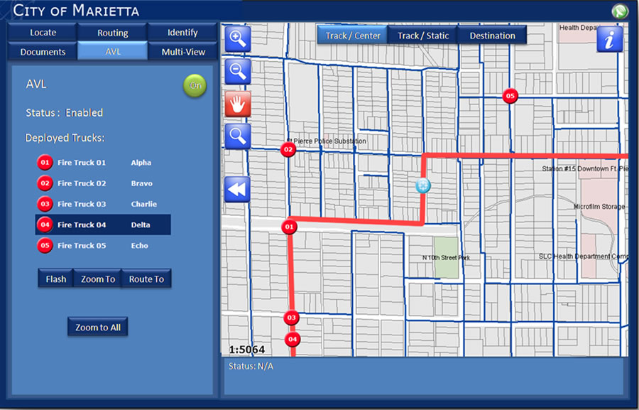 The GPS receiver supplies to the network the vehicle's location, which is updated on ArcGIS Server every five seconds. This allows on-the-fly routing, better allocation of resources, and tracking of personnel and equipment for safety reasons. |
For nearly a decade, the City of Marietta Fire Department in Georgia made do with a mapping application that was difficult to use and often displayed outdated information. Meanwhile, the city's GIS division had up-to-date data but no good way to make it available in real time to emergency responders.
Now the department operates with a state-of-the-art mobile mapping application that can route and re-route fire trucks on-the-fly. The application operator can even steer firefighters to entry points, hallways, and stairs in a mapped building that may be hidden behind thick smoke but are clearly visible on the computer screen.
Recently the city's IT department and fire department, working as partners, reviewed options for making better use of the city's existing data and infrastructure and upgrading its fire mobility application. The city contracted with Geographic Information Services, Inc. (GISi), an Esri business partner, to design and implement a new server-based application.
"Our emergency response system used an application that we set up 10 years ago," says Bruce Bishop, the city's GIS manager. "Firefighters were able to view maps, [but] . . . the data wasn't maintained or accurate. They had to download new data, which they would often forget to do. They also needed a lot of functionality that was not available on that application."
Esri ArcGIS Mobile Application Developed
The system that GISi developed—an Esri ArcGIS Mobile application built on ArcGIS Server Advanced Enterprise Mobile Software Developer Kit (SDK)—is a powerful and highly customized mobile application that communicates in real time with the city's enterprise databases, eliminating the need for manual data updates. The city and GISi also developed and deployed an ArcGIS Server API for Flex application to track the real-time locations of fire department vehicles. It provides firefighters real-time location information and a better means for situational awareness, incident response, and planning. The new system has introduced several key features that the old system lacked, including automatic vehicle location (AVL), routing and rerouting capabilities, and access to building plans, integrated into a single, easy-to-use application.
Firefighters, paramedics, police officers, and other emergency responders need accurate, reliable, and user-friendly vehicle navigation systems. Basic geographic data, such as the centerlines and names of streets, also must be up-to-date—a challenge in any fast-growing metropolitan area.
Quick and easy access to aerial photos and drawings of buildings to which emergency responders may be dispatched can provide a great tactical advantage. Firefighters need the ability to preplan their routes to and escape routes from buildings and other facilities. They need to be able to do all of this quickly in fast-paced, stressful situations—without having to become GIS experts.
An application operator can use the new system, for example, to guide firefighters to entry points, hallways, and stairs that may be hidden behind smoke but can be seen clearly on the computer screen. If there is no floor plan on the network yet, the Internet connection allows the operator to find an aerial photo online.
"Our new mobile GIS combines all the capabilities of GPS mapping and locating into one software solution," says Marietta assistant fire chief Kelly Caldwell. "Before, we had to toggle between multiple solutions. Now, we can move easily between all the different views."
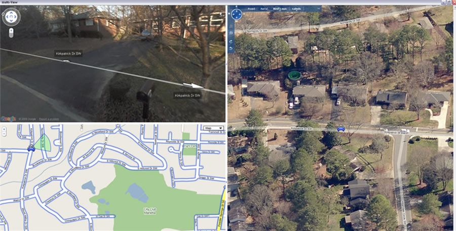 Tri-View displays the locations of hydrants as well as a 360- degree view of individual buildings and the areas around them, including floor plans and plat images. |
One feature of the new system, Tri-View, displays the locations of fire hydrants as well as a 360-degree view of individual buildings and the areas around them, including floor plans and plat images. Another feature alerts users to the presence of hazardous materials or chemicals in a building. More and better data—and more time to review it while en route—yields better tactical decisions.
The new application allows crews to reroute in case they find out midtrip that they cannot get through an area due to traffic or road closures. When minutes or even seconds count, this is critical. Routing and rerouting capabilities also come in handy in mutual aid situations, when firefighters are called to assist in a neighboring jurisdiction where they are unfamiliar with the streets.
In each Marietta Fire Department vehicle, the new application is installed on a laptop connected to an OnComm-Rocket communication hub, which combines a mobile broadband card, a Wi-Fi receiver, and a GPS receiver into a single hardware unit. The broadband card provides continuous Internet connectivity, allowing the laptop to communicate with the network to display event locations and calculate driving directions.
Wi-Fi connectivity facilitates the automated syncing of replicated GIS data between the mobile applications and the enterprise GIS database when the vehicle pulls into its fire station. The GPS receiver supplies to the network the vehicle's location, which is updated on ArcGIS Server every five seconds, allowing on-the-fly routing, better resource allocation, and tracking of personnel and equipment for safety.
"The fire department really likes the ability to access plats and building plans, as well as the different views—3D view, street view, or routing view—that are now available," says Bishop. He also points out that it is easier for the GIS staff to support the new system because it "can have the data at one central location that other departments can access."
ArcGIS Mobile technology allows developers and designers to create user-friendly and efficient applications. Marietta's mobile application's large buttons and intuitive interface are "fat finger friendly," allowing firefighters to easily use it in their trucks. It includes custom queries and an autocomplete function, so that it dynamically creates a list of valid values as the user begins to enter a query.
Currently, the new system receives most of its data from the city's GIS. However, it also takes advantage of free ArcWeb Services as well as street centerline data collected by third parties. For routing, it uses ArcGIS Online services, which are free to organizations that have an Esri ArcGIS Server license. Whenever the GIS division edits or enters new data, all the trucks automatically receive that update.
The City of Marietta's successful implementation of its new mobile GIS system was due mostly to four factors: advances in technology, such as server-side applications and wireless data networks; the fire department's existing infrastructure; the cooperation between the fire department and the city's GIS division; and the city's partnership with GISi.
The result? A system that greatly improves response time and tactical decisions in emergencies, thereby saving more lives and property.
For more information, please contact Kevin Stewart at 205-941-0442, extension 35, or kstewart@gis-services.com.