ArcWatch: GIS News, Views, and Insights
June 2012
Mapping Election Results in Real Time
Free Templates Make It Easy for Sangamon County, Illinois, to Build GIS-Based Web and Mobile Applications
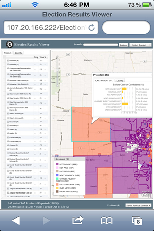
Sangamon County, Illinois, used Esri's election results viewer template to create an interactive mapping application that provides a real-time, spatial view of election results from the web or a mobile device. Home to Illinois' capital city of Springfield and nearly 200,000 residents, this midsized county is leading the way in leveraging its GIS resources to communicate with citizens.

Users can select a precinct to quickly view the results of each race at the national and local levels, and then switch to the county-wide results for comparison.
During past elections, as the results came in, they were shared with the public on the county's website in a tabular format. But it was difficult to see which candidates were winning and where, especially when there were numerous local, state, and national races taking place at the same time. Now, the county's election results viewer gives the public a comprehensive, easy-to-understand view of incoming tallies on a dynamic map.
After testing out an application prototype, county officials suggested modifying it so users could view the results of all races in their selected precinct and then switch to a view of the overall county outcomes for comparison. With help from Esri partner GISi, in less than two months, the county customized the application to test it during Illinois' primary elections before launching a public version for next fall's general election.
"This app will give the public a visual relationship with the results instead of just static tabular data," says Sangamon County clerk Joe Aiello.
The application also gives the county the ability to share results faster than it could with tabular lists. Using the previous method, it took about five minutes to post incoming elections data on each race from each precinct. With some modifications to the election results viewer template, the county can now input the data extracted from hard-copy ballots directly into the mapping application within two minutes.
The application gives citizens the first detailed look at new precinct boundaries, which were adjusted in the recent decennial redistricting process. Though the county offers a basic map of the new precincts online, the application provides a more user-friendly way to view the exact locations of new boundaries and the local candidates who are competing to represent each one.
"Most people are familiar with the old precincts, so the fact that this helps us inform them of the new boundaries is an added benefit of the app," says Sangamon County GIS manager Tracy Garrison.
After seeing how easy it is to use Esri's web mapping application templates to extend the value of its GIS, the county is considering building additional applications, starting with a tax parcel viewer. "Anyone, any county, can do this," Garrison says.
To browse all free mapping application templates for local government, visit esri.com/arcgisforlocalgov.