Evaluating the Extent of the Land Mine and UXO Problem with GIS
By Carla Wheeler, ArcWatch Editor
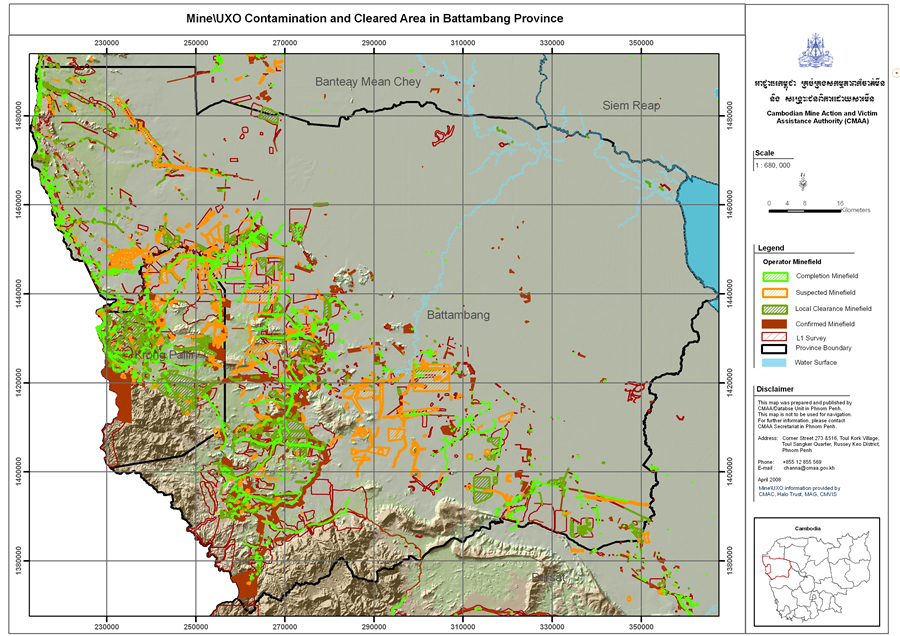 This map shows suspected land mine fields in orange and confirmed land mine fields in red in Battambang Province in Cambodia. The areas marked in green have been cleared of mines. Image courtesy of the CMAA. |
GIS analysis by the Cambodian Mine Action and Victim Assistance Authority (CMAA) will do more than support Cambodia's request for extra time to meet the Ottawa Convention's requirement to clear away known mines and unexploded ordnance (UXO).
The maps and statistics CMAA generates will also help demining operators, such as the Cambodian Mine Action Centre (CMAC), Mines Advisory Group (MAG), and Halo Trust, better pinpoint where their work will do the most good. The products CMAA creates to get a sharp picture of the land mine/UXO problem include statistical tables, charts, and maps that show
- Locations of accidents caused by land mines and UXO
- Genders and age groups of people hurt or killed
- Locations of mines and UXO that have already been cleared
- Locations of suspected mined areas using the information from the National Level One Survey
- Results of the technical surveys (Though villagers provide important input, that information must be backed up by technical surveys that more accurately reflect the scope of the problem.)
- Locations of where the American military dropped bombs during the Vietnam War (based on data supplied by the U.S. government)
Arleen Engeset, technical advisor for CMAA's national database project, says that because of limited time and money, which often comes from donors, it's important to reduce the amount of land classified as contaminated by land mines and UXO. That can be accomplished either through demining or an official declaration that the land is clear. According to the CMAC Web site, 4,466 square kilometers of land were identified in the National Level One Survey as having suspected land mine/UXO contamination.
"We need to reduce the areas and make sure that clearance is only carried out where it is needed," says Engeset, sent to Cambodia by Norwegian People's Aid (NPA). "In areas where we are not sure if there are mines, a technical survey is used to identify the mined area."
A technical survey can confirm no danger exists. Or, as is often the case, the government can declare the area at low risk for mines/UXO after farmers have returned to cultivating the land and no accidents have occurred within three years.
 This map shows in orange the locations of where the American military dropped bombs in Cambodia during the Vietnam War. The data was supplied by the U.S. government. Image courtesy of CMAA. |
The GIS analysis this fall will be done with an eye toward looking for places that could be removed from the list of hazardous areas.
"We will look into how much time Cambodia will need to clear the rest of its problems away," Engeset said. "We will also look at the whole country and see if there are areas that are suspected but not affected. Maybe there are no mines there. Maybe farmers have been using the areas for three years and . . . there may no longer be any danger. There will always be risk, but we can reclassify the area as low risk for the time being and focus on areas where land mines are known to exist. But to do this, we need information that has the best quality—information that is linked to the polygons that we can use later on in the Information Management System for Mine Action [IMSMA], which is the long-term plan for mine action in Cambodia."
IMSMA software, which supports data collection, storage, reporting, and mapping, provides an off-the-shelf GIS, database, and analysis toolset designed specifically for humanitarian mine action projects. The software was developed for the Geneva International Centre for Humanitarian Demining (GICHD, www.gichd.org), which provides it at no charge to the national authority set up by a country to manage demining operations.
IMSMA was first used in Kosovo and is now deployed in more than 50 locations around the world including Angola, Albania, Chad, Mozambique, Zambia, Laos, Thailand, Iraq, Jordan, and Yemen. Future plans include adopting IMSMA at CMAA, but the organization currently relies on ArcView software from Esri's ArcGIS Desktop suite as the operative national information system, Engeset said. ArcView includes the ArcMap application for map composition and geographic analysis, while ArcCatalog is used for geographic data management.
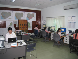 The CMMA Database Unit uses GIS to analyze incoming data related to mines and UXO and produces maps and statistical graphs that show the scope of the problem in Cambodia. |
The long-term goal of the IMSMA project in Cambodia is to bring together the data collected by mine action operations in the country over the last 10 to 15 years into a single dataset for use by the government, said Alan Arnold, Mine Action Information Systems program director, GICHD.
Esri provides some of the software used for IMSMA including ArcGIS Engine, a developer product for creating custom GIS desktop applications, and ArcPad, mobile GIS software.
"IMSMA incorporates a number of functions from [Esri's] ArcGIS Engine library to provide GIS support to mine action operations," Arnold said. "The GIS plays a central role in the system by supporting a map-driven database navigation system oriented around a local gazetteer. The GIS components give users a unique view of mine action activities through a series of interactions with field reports submitted to the database by demining organizations. The combination of a powerful set of GIS tools with a relational database makes it possible for IMSMA to play an important role in the planning, management, and monitoring of demining operations worldwide."
IMSMA also supports a field data collection tool based on Esri's ArcPad, Arnold said. "This new addition to the IMSMA support suite allows users to carry maps and data to the field and complete a variety of mine action field reports," he said. "The IMSMA Mobile tool is designed to collect coordinate data from a variety of GPS units and rangefinders, making it possible to accurately map minefields and other hazards while keeping a safe distance."
For more information about CMAA, contact Arleen Engeset at arleen@npaid.org.kh.
For more information about IMSMA, contact Alan Arnold at a.arnold@gichd.org.