GIS Used to Monitor Groundwater Quality in Pakistan
By Hamaad Raza Ahmad, Institute of Soil and Environmental Sciences, University of Agriculture, Faisalabad, Pakistan
Muhammad Sarfraz, Soil Salinity Research Institute, Pindi Bhattian, Pakistan
Philipp Weckenbrock, Institute of Physical Geography, University of Freiburg, Germany
Muhammad Irshad Dogar, Directorate of Land Reclamation, Lahore, Pakistan
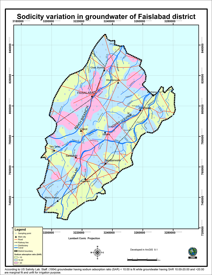 The groundwater in the areas marked in pink have high sodium absorption ratios, meaning it is unfit for crop irrigation purposes. |
The Pakistani government agency Directorate of Land Reclamation is using GIS to study the quality of groundwater that farmers in Punjab province are using to irrigate their crops. The use of groundwater for crop irrigation in Pakistan has a long history. The existence of vertical well systems, or karezes, in Balochistan was documented by Greek travelers as far back as 2,500 years ago. Persian wheels were a popular method of irrigation on the Indus Plain before the development of surface irrigation. Today, motor pumps are used to bring up groundwater. In Punjab province alone, there are now about 700,000 wells, known as tube wells, which are used for field irrigation. In 2005, annual groundwater extraction to the extent of 35 million acre feet (MAF) was reported in Punjab, a 35-fold increase since 1947. This large-scale groundwater extraction has greatly depleted the levels of good quality, or "sweet," groundwater.
Groundwater Tables Falling
This overexploitation in the sweet groundwater areas has lowered groundwater tables by two to four meters in some places, resulting in the intrusion of saline groundwater zones into overpumped sweet groundwater zones. Now more than 70 percent of tube well water is unfit for irrigation purposes because of high soluble salt concentrations.
Increased concentrations of soluble salts in groundwater interfere with metabolic processes and enzymatic activities suitable for optimum plant growth-often limiting the water uptake by plants and restricting root growth.
In the Faisalabad district that the Directorate of Land Reclamation studied using GIS, people use groundwater for more than irrigating crops. They also drink it. The consumption of such polluted groundwater containing high concentrations of soluble salts and heavy metals coming from industries and pathogens can cause health problems in people, including stomach cancer and osteoporosis (from excessive calcium loss due to ingesting high concentrations of salt).
A GIS of Sweet and Saline Groundwater Pockets in Faisalabad
Due to this complex set of problems, the Directorate of Land Reclamation conducted a study in Faisalabad district to identify the sweet and saline groundwater pockets using a GIS. A better understanding of the problems can be obtained by overlaying the sweet and saline groundwater areas with key urban features such as topography, traffic networks, and locations of towns. Urbanization leads to the generation of more municipal effluent from households and industries. In Pakistan, the drains are unlined, and this municipal effluent, which contains soluble salts, heavy metals, and pathogens, is disposed into drains where it seeps into the groundwater and affects its quality.
The use of GIS will help the farmers identify areas with sweet or saline groundwater. If they are irrigating crops with saline groundwater, they can then develop better agricultural management practices that will improve their crop growth. The study will also lead to the development of a permanent GIS database and GIS maps of the Faisalabad district.
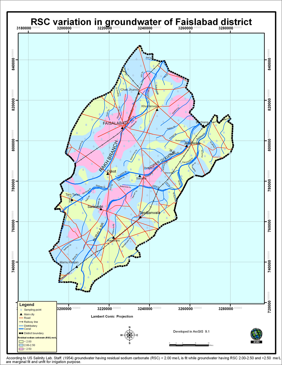 The areas mapped in yellow have lower levels of residual sodium carbonate in the groundwater than the blue and pink areas. Groundwater in the yellow areas are fit for irrigation. |
For the study, 210 groundwater samples were collected from farmers' tube wells and mapped using a GPS. Then these samples were analyzed in a laboratory to get attribute data on groundwater quality indicators such as electrical conductivity (EC), sodium adsorption ratio (SAR), and residual sodium carbonate (RSC). GIS layers of irrigation canals, roads, and railway lines, as well as main city and district boundaries, were digitized from topographic sheets with a scale of 1:50,000 using Esri's ArcGIS software. Contouring of attribute data was carried out using Surfer 8.00 software from Golden Software, Inc.
The results of the analysis showed that 84 percent of the water samples were unfit for irrigation because of high EC, SAR, and RSC values. Problems of soil salinity and sodicity can be attributed to the continuous use of saline/brackish groundwater to irrigate the crops. The GIS maps, available from the Directorate of Land Reclamation, Lahore, can now be used to encourage farmers in areas with saline groundwater to adopt better management practices such as adding sulfur, sulfuric acid, and gypsum to soil and water. This can reduce some of the negative impacts of saline irrigation water on soils and crops. Another management option is to blend brackish/saline water with sweet groundwater or canal water.
Using GIS proved to be the best strategy for not only highlighting the sweet and saline groundwater areas but also for creating a database of the groundwater quality parameters like EC, SAR, and RSC as advisory services for the farmers.
By generating the groundwater quality GIS maps, it has now become easier for farmers to know and understand the quality of their groundwater. The GIS database will also be of great help to policy makers. For more information about the project, contact Hamaad Raza Ahmad at khamaad@gmail.com.