Wiki.GIS.com
By Collin Welbon, Wiki.GIS.com Administrator, Esri
What is a cartographic relief depiction, COGO, or a Dymaxion Map? Who is Erwin Raisz? Where and what in the world are Here be Dragons?
 The wiki.GIS.com main page displays a featured page, featured map, tips and tricks, and a popular categories revolving tag cloud. |
The answers to these and other questions are on the new wiki.GIS.com Web site, an online encyclopedia filled with more than a thousand entries defining and describing terms related to GIS and other geospatial technologies, ArcGIS software, cartography, mathematics, surveying, remote sensing, and many other topics. Pages are also devoted to the pioneers of geography such as Raisz, Roger F. Tomlinson, and Bernard J. S. Cahill.
How to Use wiki.GIS.com
Wiki.GIS.com can be used in many different ways: as a reference tool, as a place to share your GIS knowledge with the GIS community and utilize your editing skills, and as a Web site where you can upload a useful map for all to enjoy, to name a few. There are many different opportunities for GIS professionals (GISPs) and students and educators to become involved in wiki.GIS.com's evolution. Students and GISPs can use the wiki as a GIS reference tool and contribute their new discoveries and foundational information about GIS to the wiki. Educators can use wiki.GIS.com to get students involved in writing about GIS concepts and/or collaborating to expand on current content and pages.
The wiki is for anyone and everyone involved or interested in the world of GIS.
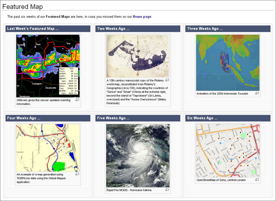 The featured map page displays the maps that have been showcased over the last six weeks. |
Like any wiki, it's a work in progress. Contributors continually shape and expand upon the content. You need not be a GIS expert to participate, either. For example, you can contribute a map, help with copy editing, or add information about a subject about which you are knowledgeable. Contributions are especially welcome in professional fields such as education, medicine, forestry, government, and public utilities.
Why Start wiki.GIS.com?
Wiki.GIS.com provides a knowledge-sharing platform for the GIS community and anyone interested in learning about GIS.
Anything—from an ever-growing list of GIS-related blogs to System Design Strategies, a constantly evolving white paper by Dave Peters—can be found on wiki.GIS.com. There are numerous maps, such as the animated map of the 2004 tsunami in Indonesia, which are linked to the wiki content with which they are associated.
Esri launched the site in November 2009 to provide a resource that would get the GIS community involved in the ongoing process of creating and collaborating on articles about GIS topics and concepts. The GIS community shares content ownership. The site is currently maintained and operated by the wiki administrative team in Esri Support Services (ESS).
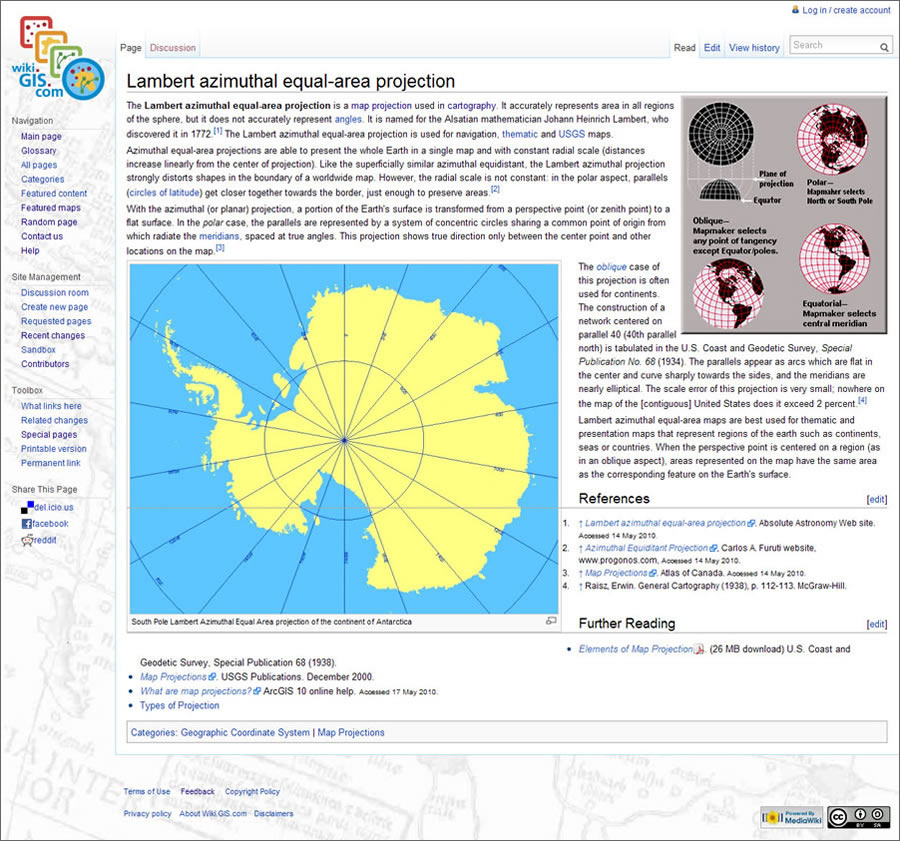 This page defines the Lambert azimuthal equal-area projection and how it is used in cartography. |
Feedback shows that most users see wiki.GIS.com as a useful tool and an excellent platform for GIS knowledge. Currently, a small team of Esri moderators ensure that content is GIS-centric and edit derogatory or mismanaged content. As wiki.GIS.com grows, more moderators will be needed. If you would like to become a moderator on wiki.GIS.com, contact the wiki administrator. Send questions or feedback to admin@wiki.gis.com or click the Feedback link located at the bottom of each wiki page.
Start Playing in Sandbox
First-time contributors or editors to wiki.GIS.com can use the Sandbox to practice and work with wiki markup language before forging ahead with creating or editing content. There is a Sandbox link within the site management navigation box on the left-hand side of any wiki page. Sandbox is a place where you can practice using wiki markup language, create your page to design its look and feel prior to creating the actual wiki page, and work with images and links to see how they will look once they are added to a wiki page. There are many other ways to utilize Sandbox within wiki.GIS.com as well. The Help pages provide an excellent reference for new users.
Contribute a Map
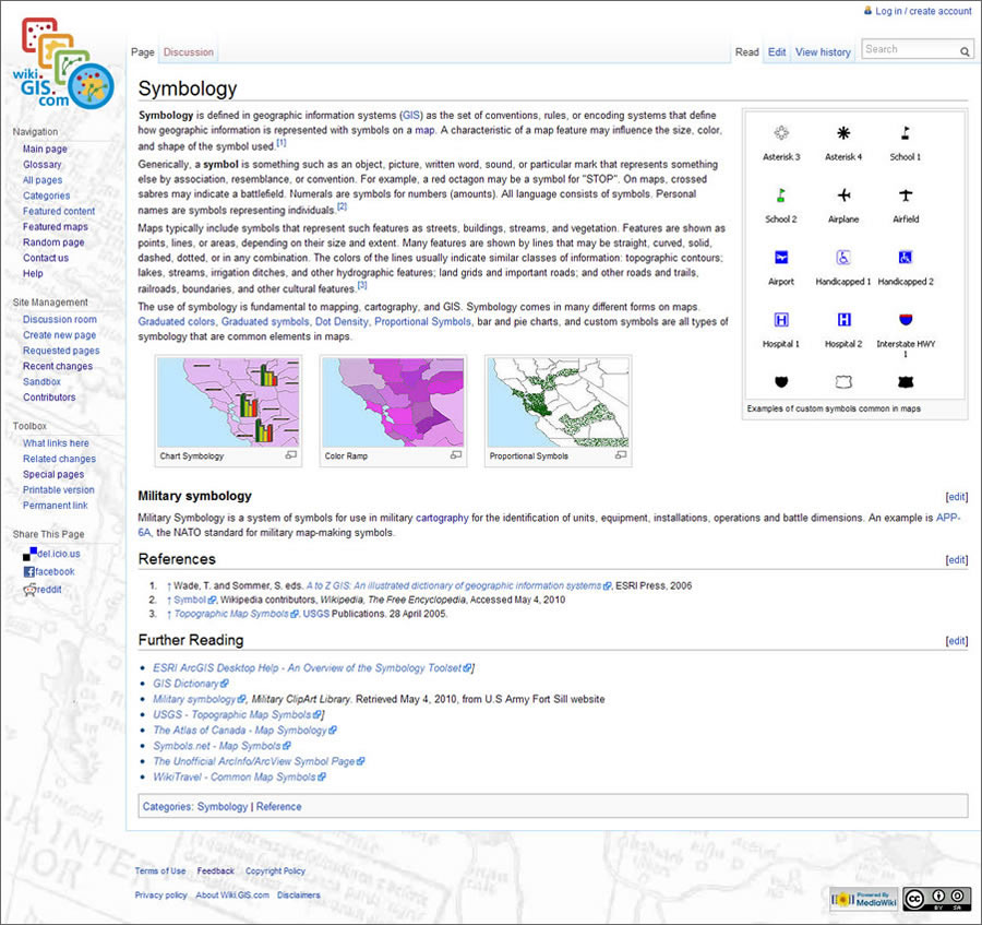 This page defines symbology and discusses how symbols are used in maps. |
The Featured Map section on the main page of wiki.GIS.com showcases a map. A new one is added weekly and the others archived for six weeks. If you have a map that you would like to contribute, upload the map to wiki.GIS.com using the Upload file link within the toolbox links on the left-hand side of each wiki page (you must be logged in to upload files/images). Once you have uploaded the map, create a wiki page about the map, including any metadata that you would like to share with the community as well as factual or conceptual information about the map, which should include its relation to GIS and/or what the map is used for within GIS or the industry that it is focused on. After creating the wiki page, link the map to the page.
The preferred method for doing this is to place it on the page—usually in the right-hand corner—as a thumbnail with a caption. Please refer to the following syntax:
[[Image:<the exact name of the image file, including the image tag, such as .jpg>|thumb|right|<place your caption here>]]).
You can also refer to the Help: Adding images wiki page for more information.
The wiki administrative team is currently working on creating a map library within wiki.GIS.com where your maps can be displayed for everyone to view, learn from, and enjoy.
As more people participate, wiki.GIS.com will continue to grow into a resource that is always evolving within the world of GIS and therefore continuing to educate more people about GIS. Because wiki.GIS.com can be easily edited and constantly evolving, the site can potentially contain the most current and relevant information available. Come aboard, contribute, collaborate, and enjoy wiki.GIS.com.
|