ArcWatch: Your e-Magazine for GIS News, Views, and Insights
July 2011
The Boy Scouts of America Receive a Complete Geospatial Picture of Philmont Ranch
A Gift of Imagery
Northrop Grumman donated imagery of the Philmont Scout Ranch to the Boy Scouts of America.
In 2010, the Boy Scouts of America celebrated its one hundredth anniversary. To commemorate that milestone, Northrop Grumman presented the organization with high-resolution imagery of its Philmont Scout Ranch, near Cimarron, New Mexico. Northrop Grumman also gave the Boy Scouts a Commercial Joint Mapping Toolkit (CJMTK) Geospatial Appliance (CGA) loaded with software that was donated by Esri.
The Philmont data, which Northrop Grumman collected, processed, and exploited, will be used by the ranch's GIS department to better manage the property and otherwise enhance the experience of the Boy Scouts who venture to the ranch each year.
Established in 1938, Philmont Scout Ranch encompasses 214 square miles of rugged mountain terrain in northern New Mexico that includes several peaks over 11,000 feet. The ranch also has access to 190 square miles of an adjacent national forest.
Every year, thousands of Boy Scouts make the trek to the ranch for a two-week, high-adventure excursion that includes hiking, horseback riding, rock climbing, mountain biking, and camping in and around the ranch's 55 campsites.
Using the high-resolution dataset that Northrop Grumman provided, the GIS and conservation staff at the ranch will be able to better manage the property and protect and preserve its natural resources. This will ensure that, for years to come, scouts will have access to this excellent facility.
One example of how the geospatial data will be used relates to the 2002 Ponil Complex fire. This fire consumed 90,000 acres, including approximately 30,000 acres on Philmont Ranch alone. The forest fire was the largest on record in New Mexico history, and suppression costs were estimated at $14 million. The imagery allows Philmont staff to check on reclamation projects already in place and identify areas that still need additional work.
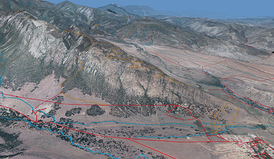
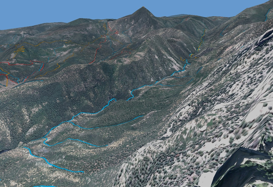
A dramatic study of the Tooth of Time ridge at Philmont Scout Ranch in New Mexico was created with imagery from Northrop Grumman and GPS tracks.
The Philmont Project
The idea for the project grew from Northrop Grumman's desire to collect, process, and exploit data from a single area to showcase the company's full range of end-to-end geospatial capabilities. Philmont Scout Ranch was chosen, in part, for its having a variety of topological characteristics, such as mountains, rangeland, lakes, and rivers, which provides diversity for the different types of data collected. The Philmont Ranch GIS department has used Esri's ArcGIS software for many years. Additionally, several of the Northrop Grumman employees working on the project are former Boy Scouts or have ties to the organization through being a troop leader or parenting a scout. This project enabled the company to give something back to the Boy Scouts during its centennial celebration. Northrop Grumman collected the imagery over several months in late 2009 and early 2010. The company's fleet of planes collected the data using advanced light detection and ranging (lidar) and electro-optical and infrared (EO/IR) sensors. The EO/IR sensors were used to gather four-band imagery at the 1-foot resolution covering 330 square miles and 6-inch resolution covering 70 square miles of the ranch. The lidar sensor collected 1-meter elevation postings covering 400 square miles of the ranch.
The data was processed at Northrop Grumman's geospatial facilities in Gainesville, Florida, and Huntsville, Alabama, using advanced processing capabilities to create orthrorectified imagery products, digital elevation models, and lidar extracted 3D buildings. Northrop Grumman staff in Chantilly, Virginia, took the existing Philmont vector data, georectified it, and performed additional feature extraction to provide a more detailed dataset.
Putting the Imagery to Use
The Philmont staff is currently building fly-through models of each of the preplanned itineraries of treks that the ranch offers to better illustrate the trips. The scouts will have a chance to see their trek during their first day at the ranch. The data also will be used for
- Managing land-use activities such as forest typing for logging
- Erosion detection and control
- Better understanding of the current configuration of Philmont land
- Helping Philmont understand ways in which it can expand its operation to bring more scouts to the ranch
- Creating better maps for scouts to use on the property
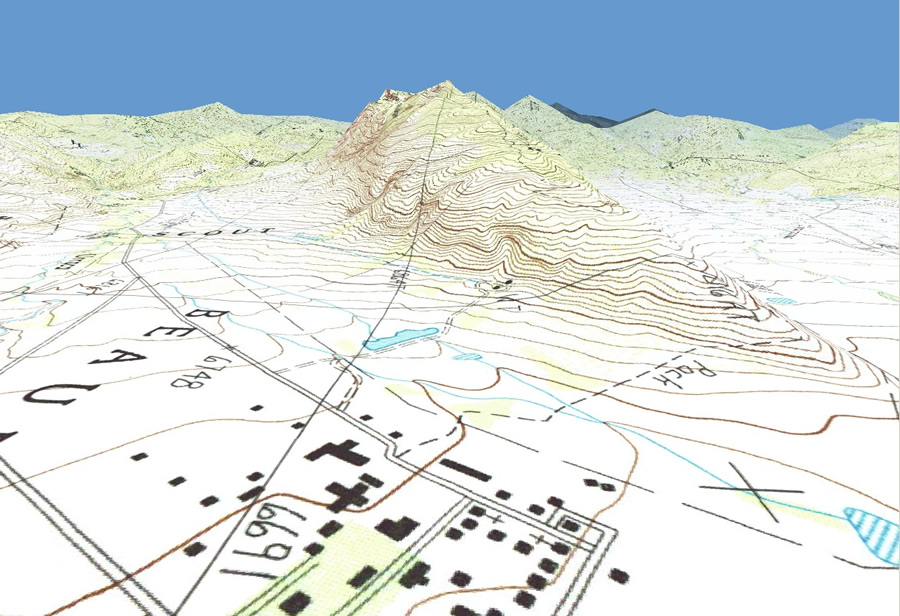
A United States Geological Survey topographic quadrangle map draped over the terrain shows how the contour lines change with the terrain.
At this time, the data is not available to the public. The ranch tries to control how much information scouts receive prior to their arrival at the ranch. A significant part of the scouting experience at Philmont Ranch is for the scouts to find their way across the property with a map and compass, using basic skills every scout needs to know. The staff recognizes that more and more people are transitioning to GPS, and, although it is good to know how to use GPS, ranch officials feel the importance of using a map and compass outweigh the need for publishing data that people can download and plug into a GPS. Philmont Ranch staff supports any scout project related to geospatial intelligence. This support includes clipping a portion of the Philmont Ranch master dataset for scouts to use. Scouts can request this data at any time. Philmont staff usually approves the requests as long as the data is used in good faith by the scout.
The CGA at the Ranch
The CGA is a high-performance server built by Northrop Grumman in partnership with Esri. The appliance was built to provide fast and easy access to maps from the National Geospatial-Intelligence Agency (NGA) and commercial sources. The CGA that was donated to the scouts did not include NGA data. However, Northrop Grumman collected new data and used existing geospatial (vector) data that Philmont had previously collected.
At its core, the CGA utilizes Esri's ArcGIS Server 10 with the ArcGIS Server Image extension to host the geospatial data as data services. Philmont staff uses ArcGIS Desktop 10 to manage the data and maps for those services. The CGA, with all the Philmont data, provides a central repository that can be easily accessed by staff throughout the ranch.
More to Come
Northrop Grumman and Esri are proud to support the Boy Scouts and Philmont Scout Ranch, and the companies plan to continue collaborating with this worthy organization as it embarks on the next 100 years of scouting.