ArcWatch: Your e-Magazine for GIS News, Views, and Insights
July 2011
Population Services International Maps, Monitors Swaziland Efforts in Fight Against HIV/AIDS
Swaziland, a rural African nation that is landlocked between South Africa and Mozambique, is home to 1.1 million people and the world's most severe HIV/AIDS epidemic. One in four adults aged 15 to 49 in Swaziland are HIV positive, according to the Joint United Nations Program on HIV/AIDS Epidemic Update 2009.
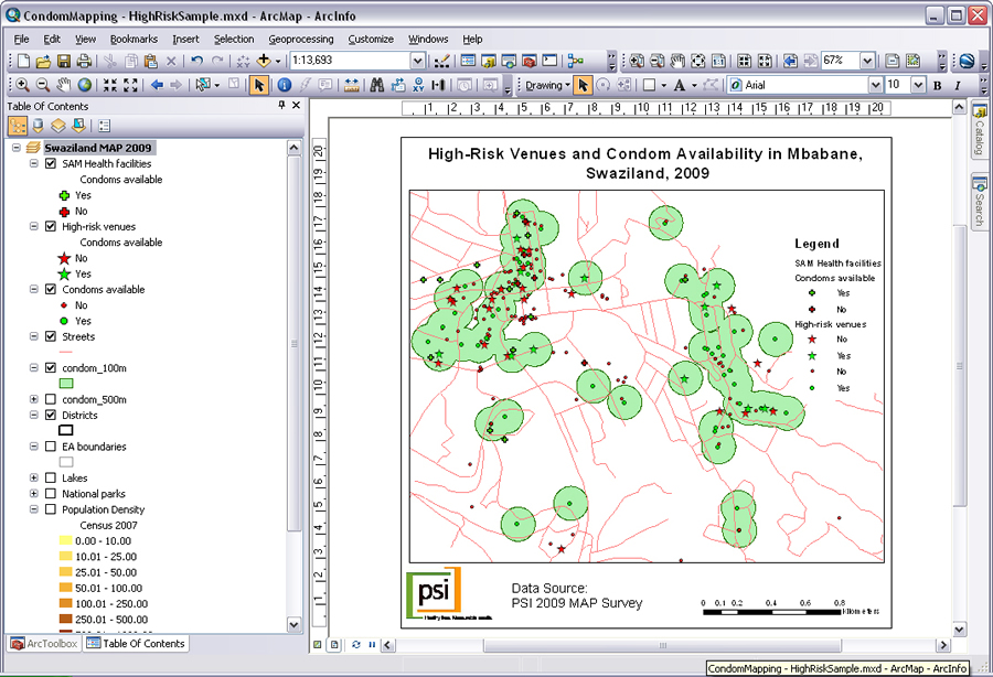
This map shows where condoms are available in relation to the locations of high risk venues for contracting HIV/AIDS in Mbabane, the largest city in Swaziland.
Population Services International (PSI), a leading global health organization, is responding to the crisis with efforts to increase access to condoms in Swaziland. PSI began implementing health programs in Swaziland in 2001, partnering with the Kingdom of Swaziland's Ministry of Health, and receiving donor support from the US President's Emergency Plan for AIDS Relief as well as Royal Netherlands Government.
Recently, PSI sent researchers from village to village to conduct a nationwide census of condom outlets. Using handheld devices and Esri's ArcPad software, PSI crews were able to collect and compile accurate condom inventory data for the entire country.
Once that data was loaded into a geodatabase, PSI staff could view supply levels at clinics, pharmacies, bars, hotels, kiosks, and brothels on an interactive map in ArcGIS. They could analyze condom availability data along with population distribution and accessibility. This allowed staff members to weigh the effectiveness of their efforts through mass media and interpersonal communication campaigns to promote condom usage. For ongoing research, PSI adopted the GIS-based methodology for analyzing condom outlet data in relation to other data collected about surrounding areas and neighborhoods.
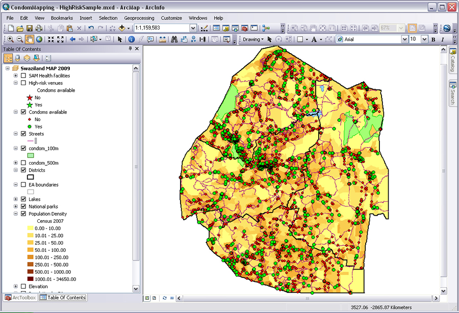
The green dots on this map show locations in Swaziland where condoms are available. The red dots show where condoms are unavailable.
"To increase access to condoms, the sales and distribution team of PSI Swaziland needed a more complete picture of where condoms were available," said Bram Piot, a geographer with PSI. "Accurate point location data is about so much more than just making a map. It builds the foundation for evidence-based analysis and more effective program planning."
PSI programs worldwide have been conducting what is known as measuring access and performance (MAP) studies since 2004. MAP is now PSI's standard tool for monitoring the availability and accessibility of social marketing products and service delivery systems. GIS was originally introduced as a tool for measuring access under MAP and is now a well-established technology for PSI programs in many countries.
"PSI country offices are increasingly using tools like ArcGIS for research and program planning," Piot said. "Providing our staff with the relevant GIS skills is also a priority for PSI over the coming years so we can make use of GIS for project planning, management, and reporting."
For more information about PSI, visit www.psi.org.