ArcWatch: Your e-Magazine for GIS News, Views, and Insights
July 2011
Sustaining the Nation's Food Supply and Security
US Department of Agriculture Implements GIS-based Integrated Plant Health Information System
With agricultural production and safety for the international market becoming increasingly important, the US Department of Agriculture (USDA) has expanded its focus on national agricultural issues to encompass a more global perspective.
The Animal and Plant Health Inspection Service (APHIS) recently implemented a GIS-based, enterprise-wide Integrated Plant Health Information System (IPHIS).
Today, the USDA not only analyzes and sustains the needs of American farmers and consumers through domestic initiatives but also assures the quality of US' agriculture to foreign trading partners to protect it from unjustified restrictions. Over the years, GIS technology has become an essential tool at the USDA to support these efforts.
"We have known for some time that while there are immeasurable benefits derived from the increase in domestic and international agricultural trade, it also poses some risks because of the possibility of the accidental introduction of foreign species that can imperil a country's food production capabilities," says Todd E. Schroeder, Business Systems Management Director, USDA Animal Plant Health Inspection Service. "With our recently implemented enterprise GIS, we are now able to better track potential problems and take remedial action when necessary."
The USDA began using GIS more than 25 years ago, developing land-cover and agricultural basemaps from its existing collection of aerial survey data. Obtaining enterprise-level GIS license followed, implemented at the department's Animal and Plant Health Inspection Service (APHIS.)
This agency's responsibilities are broad. It protects and promotes the health of US agriculture, regulates genetically engineered organisms, administers the Animal Welfare Act, and deals with wildlife damage management issues. If a pest or disease of concern is detected, APHIS takes emergency measures with the affected states or regions to quickly manage or eradicate the outbreak. By using this aggressive approach, APHIS has successfully responded to potential pest and disease threats to US agriculture.
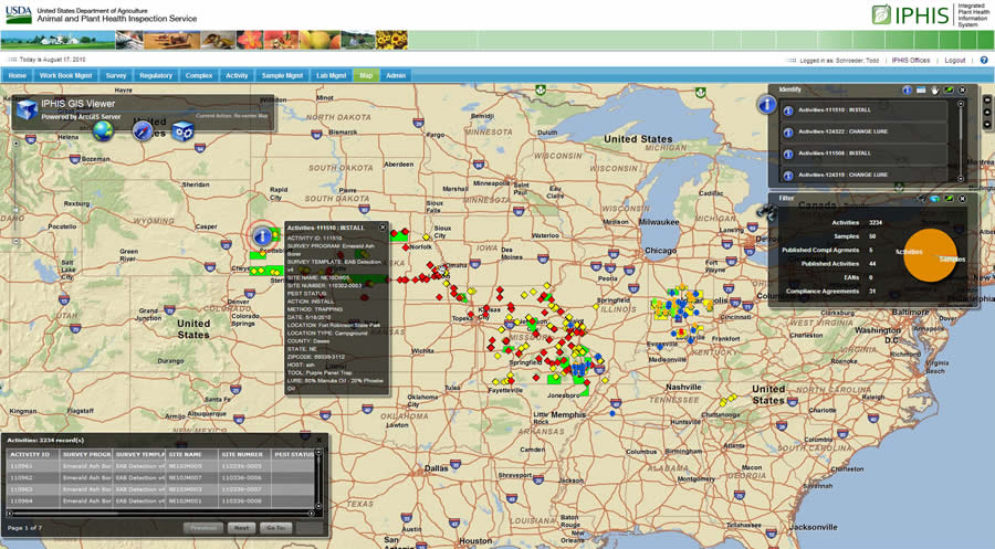
APHIS users see a comprehensive view of local information. They have the ability to drill down to detailed data at a specific location. Customizable charts provide operational statics.
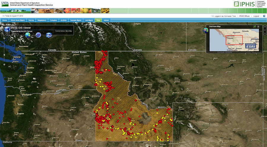
APHIS has implemented GIS-based projects to address various agricultural and natural-resource issues across the country. The agency, for example, monitored the Asian longhorned beetle and emerald ash borer, alien pests that have destroyed millions of hardwood trees. APHIS also developed and implemented the Citrus Health Response Program (CHRP), which helps the agency advise the US citrus industry and protect fruit from invasive species.
To succeed in its mission, APHIS collaborates with growers, federal and state regulatory personnel, and researchers. This enables the agency to share and consolidate data resources for various initiatives, improving the decision-making process. Because APHIS often works collaboratively, the agency needed a nationwide GIS to provide a clear and complete picture of the American agriculture and natural resource landscape. Stakeholders also needed real-time, secure data that's easily accessible and could be used for planning and operations.
Developing IPHIS
In 2009, APHIS developed the GIS-based, enterprise-wide Integrated Plant Health Information System (IPHIS) to better manage potential threats to plants from pests or disease. IPHIS has been implemented in 45 states, and the project is scheduled for completion next year. Eighty-three technicians have been certified so far to provide additional training and support the implementation efforts.
IPHIS provides a real-time system that lets users from any APHIS-supported project see plant health assignments in their district, share data about regional pest infestations, and view national quarantine areas. The system tracks infestations and diseases that may impact plants, and it documents the response from scientists and staff members. The IPHIS system, with its underpinning GIS technology, helps USDA manage operations, be more efficient, and track scientific progress more accurately.
APHIS often defines program areas based on geographical and environmental factors. Interactive data is easily viewable by a custom-defined area.
The IPHIS system's software includes Esri's ArcGIS, which allows disparate geospatial data from across the country to be compiled onto a single platform for analysis. This helps APHIS study the data entered by its field crews, providing a program-wide ability to detect and track invasive species of plants and insects.
GIS also allows APHIS to analyze infestation patterns and present clear solutions for controlling invasive species. ArcGIS provides APHIS with the ability to perform boundary mapping, route planning, risk analysis, and data filtering and use quality control indicators. Historic GIS data is overlaid with current data to spot trends and predict the spread of pests. IPHIS allows users to create customized views of specific projects and drill down to detailed data at precise locations. Customizable charts can easily be generated to visualize operational statistics.
Advantages of IPHIS
IPHIS has improved communication and transparency. Information is now easily shared between other programs and allows access to cooperating entities such as diagnostic laboratories at state, local, academic, and industry sites. This approach has provided APHIS with a modern, comprehensive, and scalable plant health data management system that promotes sustainable agriculture and safeguards the nation's food supply.
"The enterprise approach has improved efficiency by integrating and leveraging our existing plant health IT systems and isolated GIS programs, reducing redundancy throughout our network," says Schroeder. "As a vital part of IPHIS, ArcGIS has helped the USDA achieve its goals by improving standardization, accuracy, consistency, and data exchange. In addition, it allows decision makers and scientists to manage current USDA activities and develop and implement long-range plans."