ArcWatch: GIS News, Views, and Insights
July 2012
Geospatial Technology Saves Commuters Time and Money on the Illinois Tollway
Tollway Customers Use Trip Calculator and Interactive Map to Figure Out Toll Costs
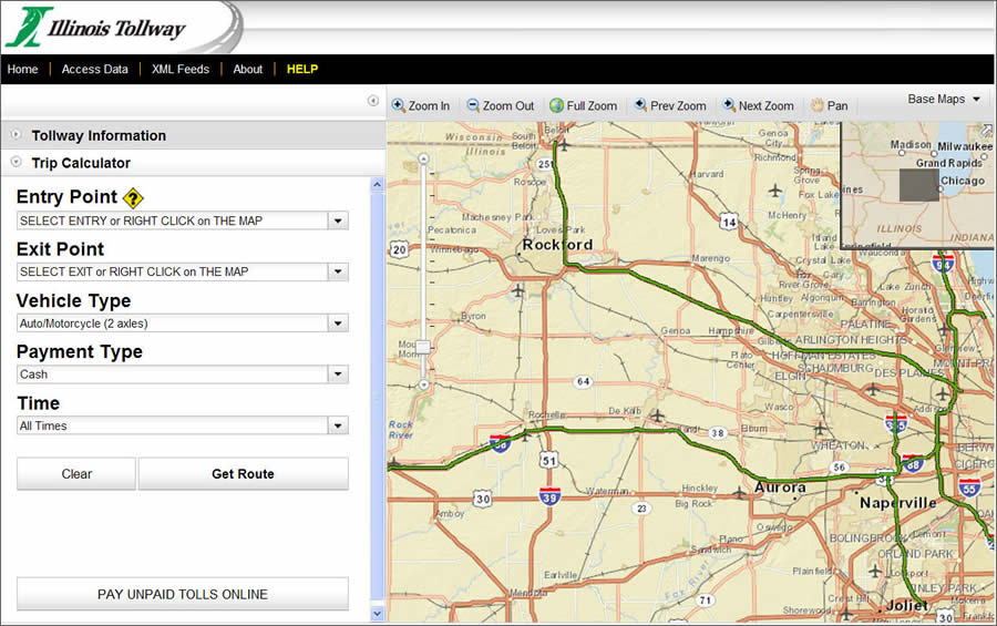
Trip Calculator users start on this page to plan their routes and determine toll charges.
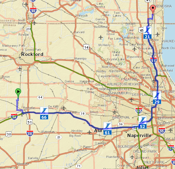
A new online mapping application created using geospatial technology from Esri helps drivers on the Illinois Tollway plan their routes and calculate what they will pay in tolls before they leave on their trips, saving them time and money. The Illinois Tollway's Trip Calculator at www.illinoistollway.com has proven popular with tens of thousands of people who travel on the 286-mile tollway system in northern Illinois.
The application's interactive mapping component also helps drivers who accidently missed paying a toll while on the road to view the route they traveled, calculate the toll, and connect to a section of the website where they can pay missed tolls online and avoid fines. More than 80,000 customers make online toll payments every month.
People select their entry and exit points on the tollway system using a dropdown menu of interstate, highway, and street names.
"The Trip Calculator is the easiest way for our customers to get clear, accurate information about the toll rates on our system," said Illinois Tollway executive director Kristi Lafleur. "It allows customers to customize their travels on the tollway and access the information they need with a few simple mouse clicks."
The Illinois Tollway's GIS team developed the application using ArcGIS technology from Esri and the Microsoft Corporation's .NET development platform. Work began on the Trip Calculator project in November 2011, and the tollway launched it in March 2012. Since then, the Trip Calculator has averaged more than 1,700 unique page views each day through May.
Mapping Out a Route
The easy-to-use Trip Calculator application provides a simple, visual way for customers to view their trip on the tollway and, based on the type of vehicle being driven, calculate the toll charges for that trip.
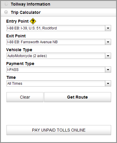
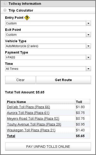
Drivers first select their route on the tollway by choosing entry and exit locations from a drop-down menu on the calculator or by right-clicking on the application's interactive map and placing virtual pushpins at the start and end points of their trip. Next, they add their vehicle type (auto/motorcycle or small, medium, or large truck). Then they choose whether they want to use cash or a less costly I-PASS. When they click Get Route, the application generates a route on the map, and the calculator tabulates the total toll amount. The application also displays the name of toll plazas where toll payments will be collected.

The users also can select entry and exit points by right clicking on the map.
Developing the Application
The GIS staff at the Illinois Tollway built the mapping application using Esri's ArcGIS API for JavaScript, mainly because it's mobile-friendly. The API gave them the ability to easily embed maps into web pages and serve the maps on mobile devices. Customers can view the maps on Android devices and iPhones.
ArcGIS API for JavaScript is a free, browser-based API for developing high-performance, easy-to-use mapping applications. The GIS staff also used existing sets of NAVTEQ data with Esri's ArcGIS Network Analyst software. Used in conjunction with the NAVTEQ street network map, Network Analyst calculates the most efficient routes of travel on the tollway system and performs a geospatial operation to determine the location of intersecting toll plazas after a customer selects the start and end points. Esri's ArcGIS for Server powers the mapping application.
After selecting their vehicle type and payment method, the users click Get Route and their toll charges appear.
Mapping Additional Tollway Information
The application was added to Illinois Virtual Tollway, an online map launched in 2008 to provide information to travelers and serve as a single point of 24/7 access for infrastructure-related information for tollway staff, consultants, and partner agencies for Illinois tollway construction projects.
Besides calculating toll charges via the route driven, the Trip Calculator offers drivers the ability to view the rates by clicking on individual toll plaza locations highlighted on the map of the tollway system. (Tolls vary by road, toll plaza, and ramp.)
The Illinois Virtual Tollway map also contains a fount of information for travelers, including the location and pop-up photographs of Tollway Oases, where drivers can stop to buy food, snacks, and fuel. People also can view milepost markers virtually and see where construction lane closures are in effect.
Through the use of Extensible Markup Language (XML) data feeds, public or partner agencies can seamlessly incorporate the tollway's daily lane closure report into their own websites, further expanding public access.
The Trip Calculator is one of many enhancements the Illinois Tollway has made to help customers access the information they need, when they need it, on the tollway website.
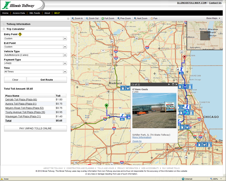
Users can also call up photographs of oases, where they can stop to purchase gas, food, or snacks.
The route they will take on the tollway will also be displayed.