The "Garden City" of Singapore Manages More Than One Million Trees with GIS Technology
By Matthew Freeman, Esri Writer
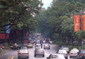 Singapore's busy Orchard Road is well known for its traffic, shopping, and trees. |
Envision a 263-square-mile island city-state that is one of the world's busiest sea ports, a major oil refining and distribution center, a leader in shipbuilding and repair, an aggressive supplier of electronic components, and home to more than four million residents. It sounds hectic, but it immediately seems more relaxing when you imagine that the same island includes more than 36 square miles of parks, open spaces, nature reserves, roadside greenery, and vacant lands. An additional 16 square miles is reserved for park land when the population reaches 5.5 million people. You are imagining the island country of Singapore, also known as the Garden City.
Trees seem to be everywhere in Singapore today. And the Singapore National Parks Board (NParks) relies on geographic information system (GIS) technology to manage data about and inspect all 1.3 million of them.
How Singapore Became the Garden City
Singapore has not always been known as the Garden City. In 1963, Prime Minister Lee Kuan Yew launched a tree-planting campaign because he recognized the importance of greenery as a factor in attracting foreign investors. However, the investors came faster than the trees. The result was a modern landscape heavy on development and light on vegetation until 1976, when the Parks and Recreation Department was formed and began aggressively planting trees and shrubs around the island. Simultaneously, the Ministry of National Development initiated road codes, which mandated that adequate planting areas be provided along new roads. An island-wide parks program led to the improvement of existing and creation of new national parks. Developers of residential areas were also required to plant roadside trees and set aside land for open space. By the mid-1980s, trees such as Angsana, Rain Tree, Yellow Flame, and mahogany and vines such as bougainvilleas and Ficus pumila provided visual relief from expanding structural development, turning Singapore into the Garden City that Prime Minister Yew envisioned.
How GIS Helps NParks Keep Track of the Trees
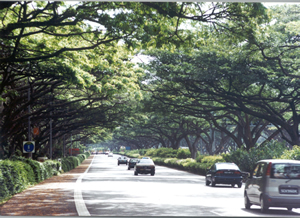 Visitors find out quickly why Singapore is known as the Garden City. East Coast Parkway, the road from the Changi International Airport to the City Centre, is sheltered by a tree canopy. |
In the 21st century, Singapore has continued its aggressive planting practices. And just as its electronics industry has flourished with new technology, so have NParks' methods for identifying, cataloging, and inspecting trees. NParks supervises 1.3 million trees located in 300 parks and on more than 2,400 hectares of Garden City roadsides using a GIS. A GIS allows users to choose different information layers and combine them based on what questions need to be answered or what data needs to be analyzed. NParks uses GIS to link information and attributes such as trees to location data such as parks and roadways. It can then layer that information to provide a better understanding and visualization of how objects are spatially related. NParks' GIS, known as the Park Integrated Management System (PRIME), is a custom software application built and hosted on an Esri ArcGIS Server platform.
NParks and other government agencies in Singapore share information through a common GIS called the Land Information Network (LandNet). A custom application also supported by ArcGIS Server, LandNet hosts an island basemap containing layers such as roads; buildings; waterlines; parks; and, of course, trees.
Updates in the tree layer of PRIME go directly to LandNet; thus, any tree data imported into PRIME becomes visible in the LandNet environment. Through LandNet, Singapore's Land Transport Authority, Urban Redevelopment Authority, and Land Authority access NParks' tree data regularly. For safety reasons and as reference to help preserve trees during the construction of new roads and the widening of existing roads, it is crucial that the Land Transport Authority knows where each tree is located along Singapore's roads and railway infrastructure. It is also useful for the Urban Redevelopment Authority to know where trees are located when planning new housing or business developments. This information can be accessed and viewed from desktop computers or used to produce paper maps.
GIS technology also supports mobile computers, which NParks uses in the field to record its tree data. NParks field crews use handheld computers equipped with ArcPad, Esri's mobile software, to log data related to the position, size, health, and species of each tree. Once data is entered, the GIS integrates with the database to generate and assign a unique ID to each tree and stores it in the PRIME geodatabase. NParks began using GIS to capture tree locations in early 2000, and currently most of the trees along roadways and in the abutting open spaces have been recorded. A smaller percentage of national parks trees have been cataloged in the PRIME geodatabase due to other constraints.
"The previous method for cataloging trees was a very manual process," says Tee Swee Ping, NParks' assistant director of Streetscape. "It involved a tedious manual ID system and a lot of paperwork. GIS is much faster and efficient and provides better documentation. It is very neat, clean, streamlined, and standardized."
Tree Health Information Imported into the GIS
In addition to importing data on the location, size, and species of the trees, data related to each tree's health is also uploaded. For legal purposes, a health inspection of the trees is conducted regularly and recorded each time a tree is trimmed. Tee says that having information about the inspection and pruning history of a tree is documented proof that NParks is giving due care to its trees. Between NParks employees who prune trees on the roadway and in the parks, those who develop new parks, and those who concentrate on how the development of land will impact existing trees, there are more than 150 workers dedicated to caring for NParks' trees.
NParks is not currently using its GIS to help manage tree-trimming cycles, although the technology exists. When asked if a GIS workflow is in the future for NParks, Tee says, "NParks is seriously looking into upgrading the current GIS in PRIME so as to utilize more of the advanced features in GIS. We know there are many more capabilities in the technology, but right now the important thing for us is capturing the location and the health conditions of each tree."
As Singapore continues a trend toward urbanization, efforts to keep the island rich in vegetation have also continued. Developers are required to replace or replant every tree uprooted during construction, and the road codes for planting along new roadsides are still enforced. New parks continue to be developed and populated with trees and shade, and government and public programs such as Heritage Tree Scheme, Heritage Roads, Community in Bloom, and Plant-A-Tree promote a good balance of industry and nature. By recording Singapore's trees in a GIS, NParks and other government agencies can ensure that these policies, guidelines, programs, and stipulations are followed.
"Quite a number of people have suggested that we implant a chip in every tree that could be read by GPS," says Tee. "What is the added advantage of that? I already have my GIS with different views and layers inside. Our goal is to get a physical description and the position of each tree in relation to other objects, and our GIS does that. We have our roadway layer in our GIS. We have our lamppost layer in our GIS. We have our tree layer in our GIS. We have good GIS basemaps, and when you add all those layers, you can visualize everything in perspective and with accuracy."