GIS Helps in 9/11 Fund-Raiser
By Jesse Theodore, Esri writer
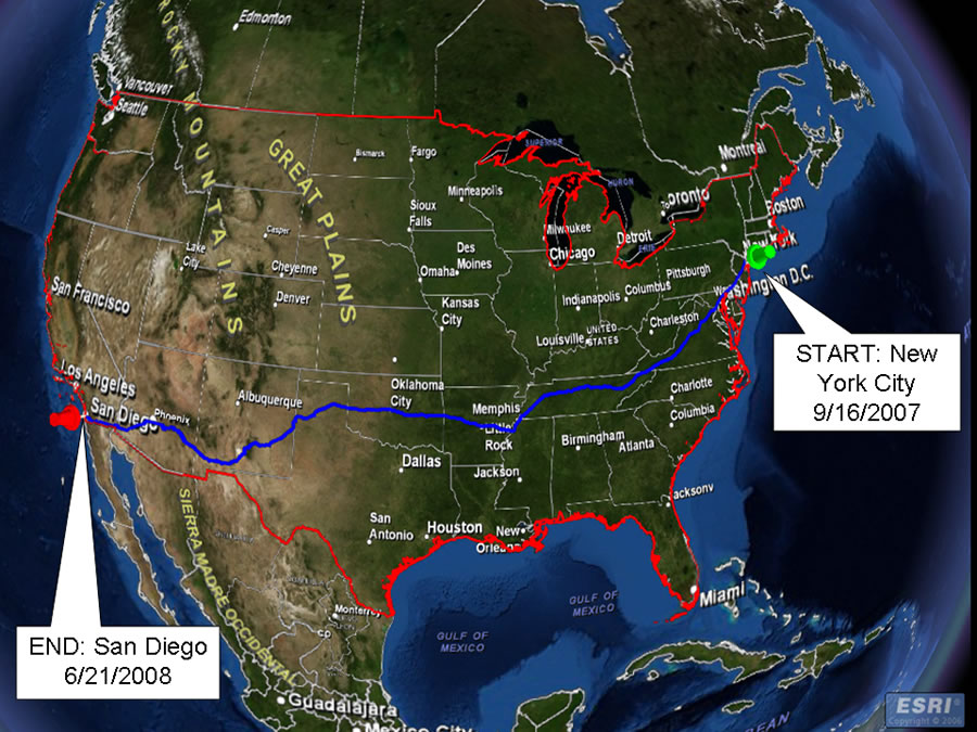 George Martin's journey took him from New York to California. |
On June 21, 2008, the weather in San Diego, California, was typical: warm, with sunny blue skies, and tempered with an ocean breeze. That's when and where former New York Giants defensive end George Martin completed a journey on foot that began in New York City and ended with his having walked 3,003 miles across the country, sometimes through wind, rain, subfreezing temperatures, and triple-digit heat.
He triumphantly crossed the finish line in San Diego, accompanied by his proud mother, whom he pushed in a wheelchair. Why did the 55-year-old former NFL captain do it? Martin wanted to raise money and awareness for the health care of rescue and recovery workers who worked at Ground Zero after the attacks on September 11, 2001.
Martin himself organized "a Journey for 9/11" (http://www.ajourneyfor911.info), which raised more than $2 million in contributions.
The journey that started in New York on September 16, 2007, was guided-indeed, mapped with precision-by the use of GIS. In August 2007, Esri was asked by project organizers to help develop a route that would be the shortest distance from the George Washington Bridge in New York City to California using roads that permitted pedestrians. The goal was also to make the route accessible to the public via the Internet so that they could see where Martin was each day as he walked across the country.
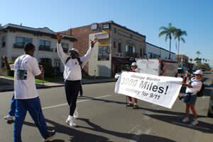 An exuberant George Martin, hands held high, walks through San Diego and toward the finish line of his of 3,003-mile walk across the United States. Photo by Kurt Harrison. |
"A great idea came to a great man," says Joan Leder, senior program director at Fairleigh Dickinson University (FDU) in New Jersey. "George Martin wanted to raise awareness and millions of dollars for the health care costs of rescue workers suffering from their heroic acts at Ground Zero in Manhattan. This GIS project included resources from Fairleigh Dickinson University and Esri developing a plan, creating a route, and displaying an interactive online map for sponsors and the public through ArcWeb Services."
Helping the Responders
The images of the September 11 attacks will always be jarring and tragic: the Twin Towers collapsing, billowing smoke, ash showering the streets, and thousands of people fleeing the scene to safety. But even more gripping images were those of the responders-police officers, firefighters, medical services personnel, and others-running toward the incident to help save lives.
Those were the images that affected Martin the most.
As more data came in that detailed the medical troubles rescue workers faced after their heroic efforts, Martin felt compelled to do something. Approximately 40,000 responders and volunteers have taken ill after inhaling toxic contaminants from the debris, with some developing lung disease and cancer.
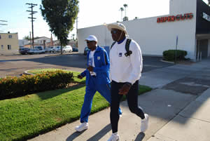 Former New York Giants football player George Martin (right) was accompanied on his cross-country journey by Lee Reeves, a student at Fairleigh Dickinson University in New Jersey and a project technology specialist for "a Journey for 9/11." Photo by Kurt Harrison. |
Martin took a leave of absence as vice president of sports marketing at AXA Equitable, based in New York, and began planning how he might be able to help raise money and awareness for those he calls the "true heroes"-those who worked selflessly to help save people and find the remains of others. Martin came up with the idea to walk across the United States, stopping along the way to promote various events in support of the mission. He wanted to raise money and gain support from participating hospitals and medical care partners to provide a dollar-for-dollar match in medical services.
As an alumnus and former member of the Board of Trustees of FDU, Martin asked the university to help create the route he would walk. The university, already familiar with GIS, approached Esri to request additional software and service support just a month before Martin would begin his march.
Fourteen cities were identified as those along the shortest route, which included Newark; Philadelphia; Washington, D.C.; Memphis; Nashville; Little Rock; Oklahoma City; Albuquerque; Flagstaff; and San Jose. The more in-depth routing began after identifying these cities. NAVTEQ street data was used with ArcGIS Desktop, including ArcGIS Network Analyst, to find pedestrian-accessible streets for the route. Additional spatial data layers were identified for completing the route. These included the locations of fire and police stations, parks, schools, campsites, food and fuel centers, and shopping centers for gathering supplies along the way.
ArcWeb Services was used to build an interactive online map that sponsors could use to plan and promote media events. The public could go online to use the map and see where Martin was in near real time as he traveled across the country. The path was tracked daily using GPS technology that linked data to the GIS. The Web site is available today showing the completed route.
"The online projected route was important in maintaining national communication across all of George's support teams," says Leder. "George had a home team that produced daily and weekly electronic maps with appropriate information such as weather and other physical conditions of the route like bridges and steep roads. The GIS was used not only for the route but also to query for pertinent attribute data necessary to secure George's safety along his journey."
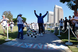 George Martin steps toward the finish line for "a Journey for 9/11" in Embarcadero Park in San Diego, as his daughter Teresa Martin waves a checkered flag. Photo by Kurt Harrison. |
Jennifer Skor, the technical architect for "a Journey for 9/11," used GIS to make quick route adjustments. Martin and several sponsors wanted to change the route to take him through Arizona so he could attend a ceremony in Phoenix. The ceremony was proposed at the last minute and would be sponsored by former New York City firefighters, emergency medical services staff, police, and others. In order to change the route and still complete the journey on time, a new route was quickly generated on the fly using the ArcMap application in ArcGIS Desktop. Martin was able to reach his new destination on time where a crowd of about 200 people gathered to honor him at the Hall of Flame Fire Museum.
"We're thankful for Esri and their support," says Lee Reeves, an FDU student and project technology specialist and George Martin's hiking partner. "They were one of the first companies to come on board. Before a Journey for 9/11 became what it was, they were there helping. And they continued to help along the way."
From Start to Finish
Martin started his hike from the George Washington Bridge in New York City and moved on to Hackensack University Medical Center, which is a sponsor that pledged to match in medical treatment costs whatever funds he raised for the emergency responders who can't afford it. He then left the medical center and walked to New York Giants Stadium for the Giants' 2007 opening game against the Green Bay Packers, where he was recognized during a halftime ceremony.
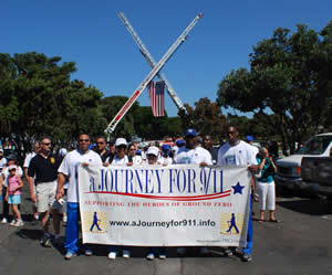 Supporters of "a Journey for 9/11", including Martin's family members (foreground holding the banner) and California firefighters and emergency responders to the New York terrorist attacks, greet Martin at Embarcadero Park in San Diego. Photo by Kurt Harrison. |
All told, Martin walked through 13 states, passing through cities such as Philadelphia, Pennsylvania, and Washington, D.C., before moving through Virginia, Tennessee, and Arkansas. He also stopped along the way in places like Oklahoma City, where he participated in a media event. Martin braved the elements. He traveled through subzero temperatures in the Midwest and triple-digit heat in the southwestern desert. When all was said and done, he averaged 22 miles a day and went through 27 pairs of shoes and 413 socks. Along the way, he lost more than 40 pounds and celebrated his 55th birthday. He only took off Sundays and days when the weather was brutally extreme.
Martin completed his journey with about 400 people celebrating and festivities at Embarcadero Park in San Diego. Sporting a white cotton T-shirt and sunglasses and looking rather relaxed after trekking thousands of miles across the country, Martin walked the final stretch with California police and fire personnel, fellow athletes, and Ground Zero responders cheering him on and giving him a hero's welcome. He made the final walk, pushing his mother, Janie Martin, in her wheelchair, with his daughter Teresa Martin waving a checkered flag to mark the completion of "a Journey for 9/11." Even then he acknowledged others. As George Martin took the last steps, he clapped his hands, turned toward the crowd of onlookers, and said, "Let's hear it for the people in uniform!"
For more information about how GIS was used for "a Journey for 9/11," contact joan_leder@fdu.edu.