ArcWatch: Your e-Magazine for GIS News, Views, and Insights
August 2011
A New Dimension
Tufts University Uses 3D GIS for Resource Planning and Facility Management
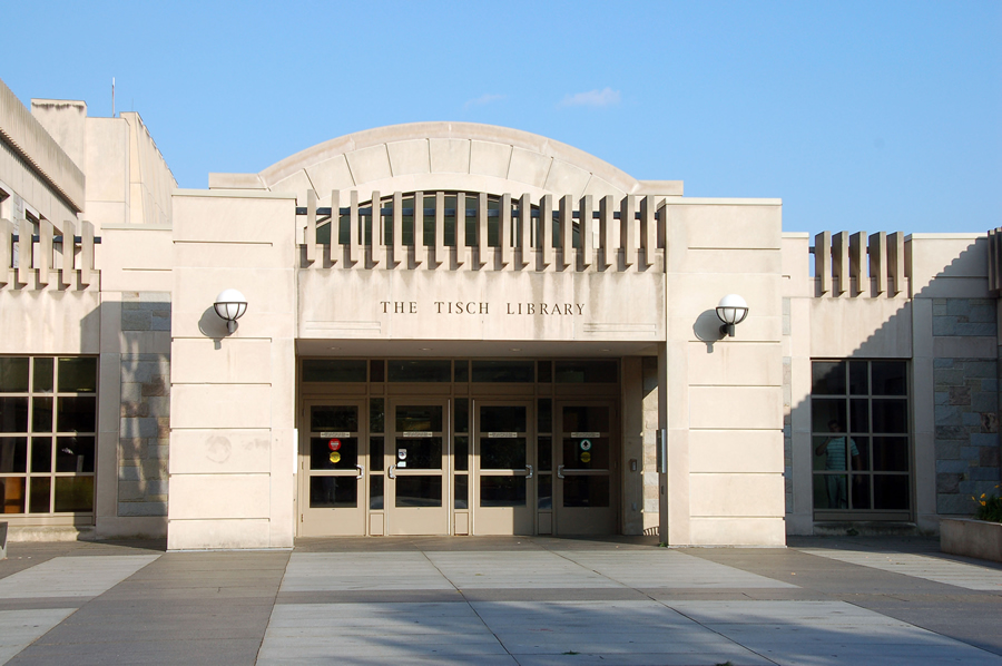
The Tisch Library on the campus of Tufts University in Medford, Massachusetts.
When prestigious Tufts University was founded in 1852, the university's president Hosea Ballou II personally signed books out to students from a small collection.
But that collection eventually grew and grew into a library system with holdings of more than 1.2 million volumes and other materials. To manage this vast collection, the library developed a 3D GIS-based information system that incorporates the library's existing data management programs.
Founded by the Universalist religious denomination, Tufts University is a small liberal arts school located in Medford, Massachusetts. About 9,000 students attend the university, which fosters a tradition of social responsibility.
Today, the largest facility in the Tufts University Library system is the Tisch Library for arts and sciences on the Medford campus. Tisch houses the majority of the library system collection including 700,000 books, 30,000 electronic journals, 20,000 electronic books, and 20,000 video recordings. The facility includes a student cafe, offices, group study rooms, research areas, and a media lab for viewing DVDs and videotapes. Tisch Library also has an active research instruction program and offers both one-on-one consultations and an instant messaging reference service.
Tisch Library continues to grow and evolve as special collections are added. There's also a need to provide supplemental materials when new courses are introduced at the university. Management of its facilities and resources is a significant concern for university library administrators, who are continually trying to improve access to the expanding collections within the confines of the existing space.
Recognizing the need to better manage both its facilities and collections, Tufts Library administrators enlisted a team of university employees, including Thom Cox, technical project manager, and Patrick Florance, GIS center manager, to help develop and implement a GIS-based library information system that incorporated the library's existing data management programs. The project was funded by the Berger Family Technology Transfer Endowment.

The main floor of Tisch Library showing room use within L-SIMS.
The Tufts University Information Technology group partnered with Tisch Library Information Technology Services [LITS] to create L-SIMS [Library Spatial Information Management System], a fully functioning, 3D GIS-based view of the interior space of the library that merges databases from LITS, facilities management, and various library collections. The L-SIMS project began with an extensive needs assessment study that involved consulting with library staff and students concerning current and potential library use, examining existing databases, and conducting a detailed inspection of the library and its contents.
The Tufts team then created a data model for L-SIMS, which involved developing a unique identifier schema to link the various feature types to the appropriate databases. A significant component of the project was the database development and conversion. The library's CAD floor plans were brought into ArcGIS, georeferenced, and cleaned significantly to create feature topology. The floor plans were ground truthed, meaning information was collected and measurements made while walking through the rooms. A significant amount of editing to the maps was performed for areas of the library that had been recently renovated.
"We hired Tufts students to complete the work, so it also became a real-world learning experience for those students looking to further develop their GIS and spatial thinking skills," said Florance.
About 30 distinct features were coded for the L-SIMS geodatabase, including rooms, walls, doors, doorways, emergency exits, stacks and shelving, fire extinguishers, panic buttons, electrical outlets, computers, and Ethernet connections, as well as the collection itself—all the features commonly found within a library. Then several different databases related to those features were integrated into the system. This included the facilities database that identifies room numbers, room use, square footage, the person responsible for the room, occupants, and so on. The LITS database was also included. This holds information about each computer in the library, such as the computer ID, the processor, whether it has a CD or DVD drive, and all the software on it. Also integrated is the collections database, which stores the different reference numbers and collection types for all the stacks in the library.
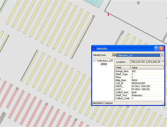
The Tisch Library collections database within L-SIMS.
L-SIMS helps reference librarians better direct students to library resources and assists with tasks such as disaster planning, determining the location and contents of special collections, and helping determine which materials are available online.
The Tufts GIS center used ArcGIS to generate high-quality maps. Key library staff members were trained and became ArcGIS users and the data stewards for the new system. Tufts also created a web-based prototype of L-SIMS using ArcGIS for Server.
"L-SIMS really serves as a resource management tool. Several library staff members have commented on how excited they are about the new system," said Florance. Previously, when changes occurred, they would have to remap sections of the library for each specific use—often a time-consuming process.
Added Cox, "Detailed floor maps are posted on each floor of the library that indicate the location of various book collections, as well as important emergency information such as exits, panic buttons, and fire extinguishers."
When library resources are altered, the maps must be re-created to reflect those changes." Now when a student comes to the reference desk requesting help locating a book, the librarian can provide an accurate, highly detailed map showing the stack where the book can be found. L-SIMS is regularly updated, so the maps produced from the database always reflect the current status of the library collection.
Using L-SIMS, librarians can also analyze the use of specific elements of the Tisch Library collection. Access to those parts of the collection that are in great demand can be optimized by relocating them to a more prominent location, while materials that attract less interest can be stored in or relocated to a less prominent place.
"It is the hope of the L-SIMS project team that this foundation work will be the impetus for the future development of a public, web-based, interactive mapping application to provide comprehensive information and access to library resources," Cox said. "Both students and Tisch staff will be able to explore the contents of the library online and identify topics of interest. For example, a user searching for a specific book could pan to a library stack to see the collection type and the related reference numbers to locate the required material. Or, they could click on a displayed computer to see what software is loaded on it."
L-SIMS is so successful that several schools and departments at Tufts have asked the library to build geoenabled SIMS or business inventory management systems (BIMS) for them.
For more information on GIS for facilities management, visit esri.com/fm.