ArcWatch: Your e-Magazine for GIS News, Views, and Insights
August 2011
Study Historic Landsat Imagery with ChangeMatters Application
Visualize Changes on Earth
The US Department of the Interior recently made worldwide Landsat data from 1975 to 2005 available to the public. Using Esri's new, free Landsat image services, you can view this Landsat imagery and see how any area in the world has changed over time.
To help you compare and visualize these changes by year, Esri, along with DTC Agile and Kass Green and Associates, created a simple application called ChangeMatters. The application overlays imagery from different years and generates an image that shows where vegetative increases or decreases have occurred. You can either overlay the change on top of the Landsat imagery or view different years (including 1975, 1990, 2000, and 2005) side by side to make comparisons.
ChangeMatters is an excellent tool that anyone from a fourth grader to a research scientist can use to better understand vegetative changes on the earth's surface. ChangeMatters is simple to use. All you need is a web browser and a location in mind.
Step 1:
Open your favorite web browser, visit the ChangeMatters Viewer page, and click the View larger link to load the full application.
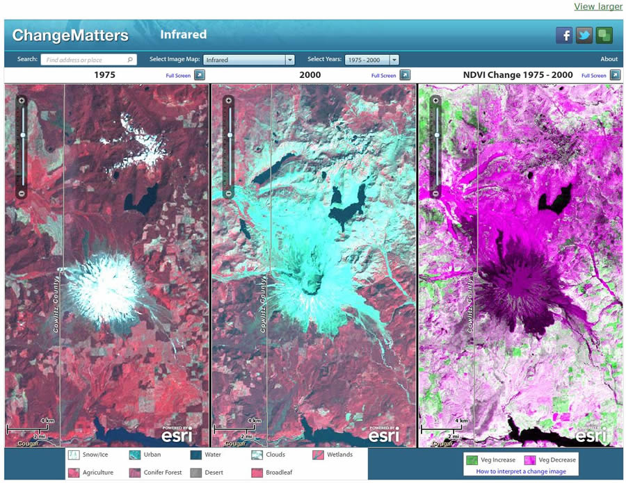
View imagery from different years side by side and compare the vegetative change.
You will notice that the left and middle panels display two different years. You can select which two years you want to compare by using the Select Years or Dates (depending on browser used) drop-down at the top of the page. The choices include 1975 and 1990, 1975 and 2000, 1975 and 2005, 1990 and 2000, 1990 and 2005, and 2000 and 2005.
The panel on the right shows the vegetative difference between the two years. This is also known as Normalized Difference Vegetation Index (NDVI). Green represents an increase in vegetation, while magenta represents a decrease. All three panels are in sync, so you can navigate around one and all the panels move simultaneously.
Step 2: Type an address or place anywhere in the world into the Search box. To visualize a location with explosive vegetative growth since 1975, search for Las Vegas, Nevada.
Step 3: Experiment with different years from the Select Years/Dates drop-down. All the panels will change to the years you choose and display the vegetative change between them on the right panel. With Las Vegas displayed, select 1975 to 2000 and zoom to the northwest side of the city. Notice all the new vegetative growth in green on the NDVI Change panel.

Las Vegas, Nevada, experienced an explosion of vegetative growth between 1975 and 2000.
With ChangeMatters, the map can be changed from the side-by-side display to a full view map. This is done by clicking the Full Screen link at the top of each panel. This loads your current location from the side-by-side view into a single map window. A great feature in the Full Screen view is the ability to change the image services displayed in the map. The image services represent different Landsat band combinations, or change images, from two different years. Applying a unique band combination is common when interpreting and analyzing the earth through multispectral imagery such as Landsat. Different band combinations enhance features on the earth's surface, so experimenting with these is an interesting way to analyze the data. Here are some simple steps to change the image service displayed in the map:
Step 1: From the Select Image Map drop-down menu located at the top of the page, select from the available image services. By experimenting with different image services over a location, you'll see that certain features are enhanced. For example, selecting the Infrared image service over Las Vegas will make vegetation appear to be red.
Step 2: On the right side of the page, under Select Year, move the slider to 1990, then switch to 1975 and notice the changes.
Step 3: Just below that, check the Overlay Change check box and choose 1975 to 2000 or any other range of years. You should now have a separate layer overlaid on top of the imagery.

Visualize vegetative change by overlaying an NDVI layer between different dates.
Step 4: Move the transparency slider back and forth to see the new change on top of the old imagery.
Step 5: Optionally, change the histogram sliders. The left (green) slider increases the vegetation and decreases water levels detected from the imagery. The right (magenta) slider can be used to map decreases in vegetation or increase detection of water levels.
The foundation of ChangeMatters is the image services that are being driven by Esri's ArcGIS Server Image extension. These services are available for use in all Esri clients including desktop, mobile, and server. There is no need to download individual images and process them. Since these are real image services and not cached maps, users can perform many types of analytic techniques such as image classification and NDVI, to name a few. The possibilities are enormous for exploring changes to the land and increasing our scientific knowledge of the world. For more information, visit esri.com/landsat.