ArcWatch: GIS News, Views, and Insights
August 2012
Cutting Down the Workload
Step by Step, Foresters Use GIS to Complete the Workflow
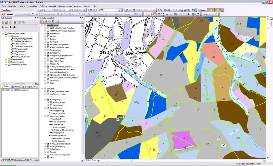
Within the work environment, users access central tools in a shared folder so they can zoom to department data, check addresses, and employ planning symbols.
Forest managers need an accurate forest inventory database that details the types of trees, where the trees are located, and their condition. The managers use this information to calculate forest timber values; manage harvest permits, leases, and land sales; and create forest plans that comply with environmental regulations. In Germany, foresters use Esri's ArcGIS Workflow Manager to complete data management tasks and GIS processing jobs quickly and accurately.
Germany's state forest agency, Hessen-Forst Enterprise, uses GIS to manage and maintain forests throughout the state of Hesse. One of the largest forest organizations in Europe, Hessen-Forst is responsible for 342,000 hectares of state forest land and an additional 350,000 hectares of other forests in Hesse. It maintains a presence throughout the state, operating 441 forester warden's offices and 41 forest agencies, as well as the Kellerwald-Edersee National Park agency.
Hessen-Forst has a large volume of data and a dispersed work force. Managers wanted to improve the efficiency of its GIS and the productivity of the staff that works with it. They asked Esri partner con terra GmbH to build a GIS data management workflow application specifically for Hessen-Forst's inventory processes. To do this, the GIS service company used ArcGIS Workflow Manager to customize an automated job tracking system that would help staff successfully complete the organization's forest inventory processes. The workflow tools were combined with the forestry business's basic GIS tools package, FoBIS, and a data model.
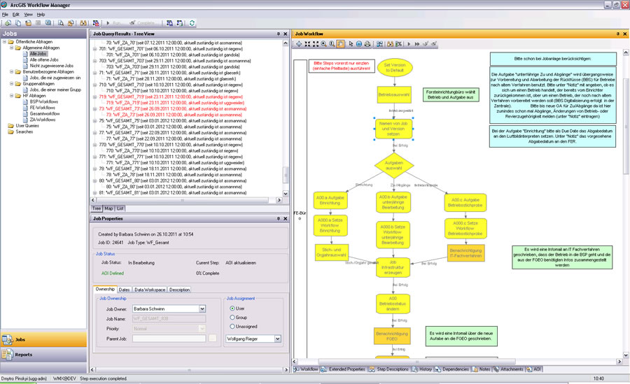
ArcGIS Workflow Manager shows the steps necessary to manage the forest inventory including data management and updating.
Once Hessen-Forst implemented the solution, foresters began using GIS to guide them through such processes as updating the inventory database after a heavy storm. ArcGIS Workflow Manager tracks the status and progress of the job and generates a detailed history of a user's work activity. It provides a historical record of job activities, detects changes in the inventory database, and tracks versions. This transparent documentation allows managers to review processes and make sure that projects are on track and completed on time.
To start a job, the user selects from a list of job types and job templates that outline the steps that need to be completed. The set of each job's operational parts is its workflow, which contains the steps required to complete the job. The user navigates the workflow using tools to complete the steps in the process.
For example, following the steps in a process, the user comes to a step and clicks a button to execute a smart launch of ArcMap. ArcGIS Workflow Manager sets up an environment in which the user will complete the relevant GIS and non-GIS tasks and shows an accompanying workflow diagram. When the user clicks a step on the diagram, it launches the tools and automated processes the user needs to finish the step. When done, the user clicks the Complete button and is ready to move to the next step in the workflow.
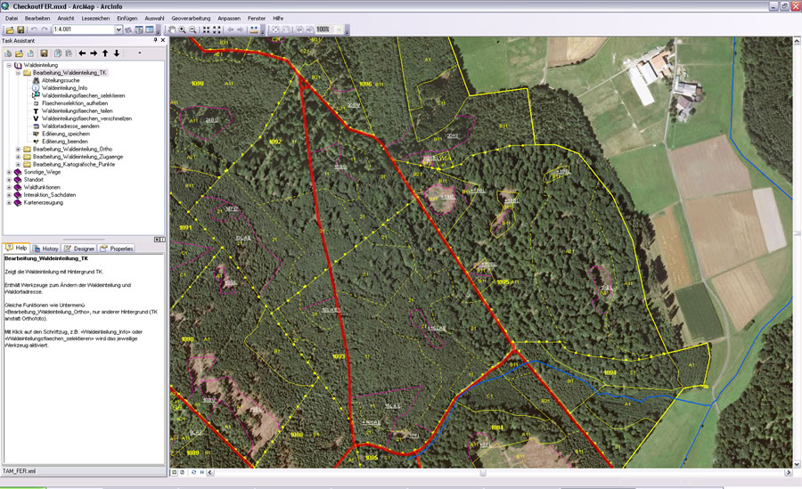
ArcGIS Workflow Manager tools update forest classification processes to add a new resource, orthoprocessing. By clicking a task, the user activates tools for completing that task.
Hessen-Forst has used Esri technologies since it first began digitally managing geodata. Today, all the enterprise's sectors have access to necessary geoinformation using Esri technology. Workflow Manager is an ArcGIS extension, so users were familiar with the tools and quickly began using it. Having a standard and easy-to-use process allows users dispersed in offices throughout the state to easily perform their work accurately and with little assistance from the GIS team.
Hessen-Forst recently launched its next-generation GIS, ForstGIS_NG. Because it too has been built on ArcGIS, foresters continue to use ArcGIS Workflow Manager. They have expanded their applications of GIS work processes to perform additional inventories, map storm damage, study forest conditions and surrounding infrastructure, identify suitable areas for industrial timber production, and more. GIS helps the enterprise's forest managers make informed decisions and meet goals for sustainable forest management.
Thanks to Wolfgang Fischer, Hessen-Forst, Germany, and Martin St�cker, con terra, Germany, for this story. Esri Deutschland GmbH and con terra developed FoBIS. Learn more by visiting the ArcGIS Workflow Manager page, or contact Martin St�cker at m.stoecker@conterra.de.