Taking the "Geographic Approach"
Using Geographic Science, Supported by GIS, Will Lead to Better Problem Solving and a Greater Understanding of Our World
By Jack Dangermond, Esri President
 GIS extends the power of geography by providing digital tools that abstract and organize geospatial data, model geographic processes, visualize these data and models with advanced computer techniques, says Jack Dangermond, Esri president. |
To gain a greater understanding of our world we need a framework that I call the "geographic approach." The geographic approach uses geographic science supported by geographic information system (GIS) technology as a framework for understanding our world and applying geographic knowledge to solve problems and guide human behavior.
Geography is the science of our world, describing our planet's physical and cultural patterns and processes. This science helps make us aware of what's going on, provides predictions of what may happen, and gives us systematic information for planning and decision making.
Geography helps us better understand various spatial phenomena and their interrelationships such as the relationships between land-use change, surficial hydrology, flooding, and biodiversity. This helps society become more conscious and aware of how our cumulative behavior is affecting the planet's evolution.
GIS extends the power of geography by providing digital tools that abstract and organize geospatial data, model geographic processes, visualize these data and models with advanced computer techniques.
GIS helps us apply geographic knowledge to improve how we work such as making our organizations more efficient and supporting location decisions that require examining many geographic factors. For example, when selecting the route for a new highway, GIS and the geographic approach can be used to consider the physical and human factors that should guide its layout and design: the environment, existing land use, terrain, and social impacts as well as engineering constraints and costs.
Considering all these factors can be overwhelming, particularly when trying to make complex trade-offs. This is where the use of GIS is particularly valuable.
Origins of the Geographic Approach
The geographic approach involves integrating many factors on a map and interpreting their meaning in a holistic way by means of map overlay. This classical method was popularized by Ian McHarg in his book Design with Nature in the 1960s.
The advent of GIS allowed planners to replace plastic overlay maps with digital overlays that could be integrated and modeled using various quantitative spatial analysis tools. These weighted overlays combine the various factors of importance based on scientific or human judgments related to a particular decision. An example might be a map showing a landscape's relative suitability for a certain land use or as the site for a new facility.
Today, biologists use this type of approach for modeling the geography of natural habitats. Similarly, hydrologists model flooding and flood risks, sociologists model neighborhoods and social behavior, and land-use planners regularly combine these types of models to better understand how to design future communities.
The geographic approach is being used in many other fields: by the military for cross-country mobility; by resource planners for forest management, mining, and petroleum extraction; and by city planners for organizing and managing urban growth. It's being used to create disaster preparedness plans and to respond to fires, earthquakes, hurricanes, and floods.
The geographic approach also helps organizations provide humanitarian assistance during famines and social conflicts. Utilities apply this approach to planning, engineering, and managing infrastructure networks, and businesses use it to select the best locations, market their products, manage territories, efficiently route vehicles, and make their business more efficient. All these applications deliver huge benefits to organizations and to the rest of us.
Societal Consequences
The geographic approach clearly provides many direct benefits but goes far beyond specific applications. It is already having profound effects on how we think about and understand the world and how we analyze and make decisions. It also affects the methods we use to evaluate choices, the way we educate our young people, how we communicate with others, our management style, and how we behave toward our environment. Yet, with all that has been accomplished, this approach has only been possible for the last few decades. That means the process of applying geographic knowledge to the full range of problem solving is just beginning.
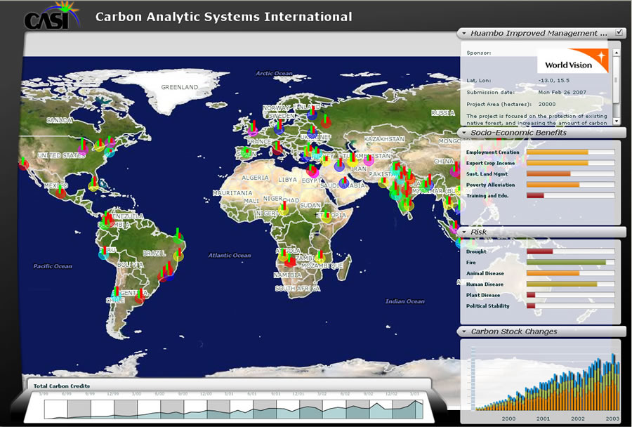 The GIS Web Services application is used to analyze the socio-economic benefits of forest preservation on carbon stock changes worldwide. |
Perhaps the most challenging application will be to understand and manage global change. Our world is changing rapidly. Continuing population growth, urbanization, consumption of natural resources, climate change, and disappearing biodiversity all make for a challenging future.
What is clearly necessary is a new approach, one that considers not just economic and political factors but also the ecological infrastructure that underpins our life support systems. Some suggest we need to change how we live: reduce energy usage, cut CO2 emissions, protect and restore natural areas, reduce our consumption, and stop polluting.
As valuable as these ideas are, it is clear the world also needs a systematic and comprehensive framework—an approach for understanding and managing human activities in the context of the environment. This approach needs to consider all necessary factors for creating and maintaining a sustainable world. Geographic science supported by GIS technology provides just such a powerful approach. It provides a new context for thinking and behaving and for designing and creating solutions for our future.
Evolving Technologies and the Role of GIS Professionals
Today, with the introduction of GIS Web services in open Internet environments, it is becoming easier for anyone to access and work with geospatial information. As these technologies evolve, they will facilitate broader and richer applications of geographic information and the geographic approach.
Despite its great success, the widespread application of the geographic approach will not happen automatically. It will require continual dedication to building and maintaining GIS infrastructure such as quality databases, strong Web applications, and all the related workflows. We will also need to foster open sharing of information and new forms of cooperation and collaboration.
Clearly, GIS professionals will play an important role in making this vision a reality. There will be an increased demand for GIS professionals in many fields throughout the world and their importance and influence will continue to grow.