Esri's New ArcGIS API for Flex Improves Look and Feel of Web Mapping Applications
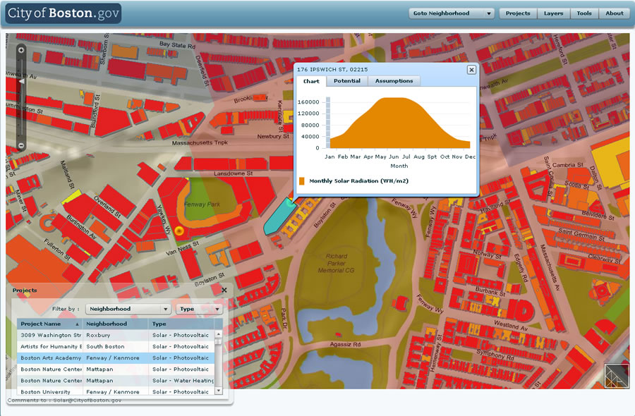 The City of Boston, Massachusetts, recently deployed Solar Boston, a Web mapping application that showcases active renewable energy installations. |
API for Flex beta can now be downloaded free from Esri by visiting the ArcGIS Server Resource Center. The ArcGIS API for Flex is integrated with Adobe Flex Builder 3. Flex is a client-side technology rendered by Flash Player 9 or Adobe AIR. This means that application developers now have the capability to combine GIS-based Web services from ArcGIS Server with other Web content and display it in fast, visually rich, and expressive mapping applications that can be deployed over the Web or to the desktop.
ArcGIS API for Flex takes full advantage of the powerful mapping, geocoding, and geoprocessing capabilities of ArcGIS services. Application end users can display their local data in an interactive map, search for and display GIS data features and attributes, locate addresses, identify features, and perform complex spatial analytics by simply clicking a button on the menu at the top of the application.
Developers can program with the ArcGIS API for Flex without installing ArcGIS Server on their machines as long as they have access to ArcGIS Server via a URL. Because the API is built on the Adobe Flex framework, developers can incorporate Flex components, such as data grid, trees, panels, and charts, in custom applications.
An early adopter of the ArcGIS API for Flex and ArcGIS Server is the City of Boston, Massachusetts, which recently deployed Solar Boston, a Web mapping application that's available to the public and designed to showcase active renewable energy installations. The application allows users to calculate potential rooftop photovoltaic capacity (the amount of solar energy that can be generated for a building) by taking roof size and shading from surrounding structures into account.
"We chose the ArcGIS API for Flex because it allowed us to leverage the power of ArcGIS Server while delivering a rich, interactive experience to our users," said Greg Knight, senior GIS applications developer, Boston Redevelopment Authority. "Development was both fast and enjoyable, and we are pleased with the functionality and performance of the application."
Boston Redevelopment Authority, the city's information systems management department, and the city's Solar Boston Program collaborated on the project, which was completed as part of Boston's Solar America Cities partnership with the U.S. Department of Energy's Solar America Initiative.