Harvard University Launches China Earthquake Geospatial Research Portal
By Carla Wheeler, ArcWatch Editor
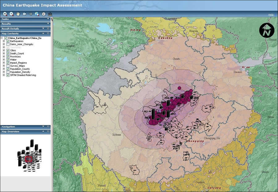 Data collected through the China Earthquake Geospatial Research Portal (CEGRP) can be viewed and investigated by using a map service published by ArcGIS Server. |
Security, video, and cell phone cameras captured the terror in real time: Frightened faces of people scrambling for safety or crouching under desks as buildings rocked and trees swayed during the magnitude 7.9 earthquake that shook Sichuan Province in May 2008.
Even more disturbing pictures and video came later as crumbled buildings and landslides slowly gave up the victims: 69,197 people were confirmed dead and 374,176 people injured, according to Xinhua News Agency. About 18,000 people are still listed as missing.
The images, however, only tell part of the story about what some call the Wenchuan or great Sichuan earthquake. Scientists, scholars, and other researchers have started to collect seismic, environmental, geologic, and demographic data along with GIS datasets, layers, and maps related to the quake—some of it now appearing on the new China Earthquake Geospatial Research Portal (CEGRP) (http://cegrp.cga.harvard.edu/) hosted at Harvard University.
On the CEGRP Web site, people will find links to free satellite imagery, GIS layers, tabular datasets, disaster recovery policies, and other reports. Some of the downloadable datasets include GIS layers in shapefile and KML file formats that show the epicenters of the earthquake and aftershocks; impact zones of the most severe seismic activity; the county boundaries that fall within the impact zones; and the estimated number of people killed by the quake, calculated by county-level districts. The site's visitors also will find a geologic map of Sichuan Province, the dams in the Chendu region, and power plants in China. More data is added as organizations and individuals contribute. Those that register on the site can also upload analyses or completed GIS datasets to share with other researchers, students, or colleagues. "What we wanted to do is create a portal that becomes a place to go to for sharing the data as well as a permanent archive," said Merrick Lex Berman, the portal's developer.
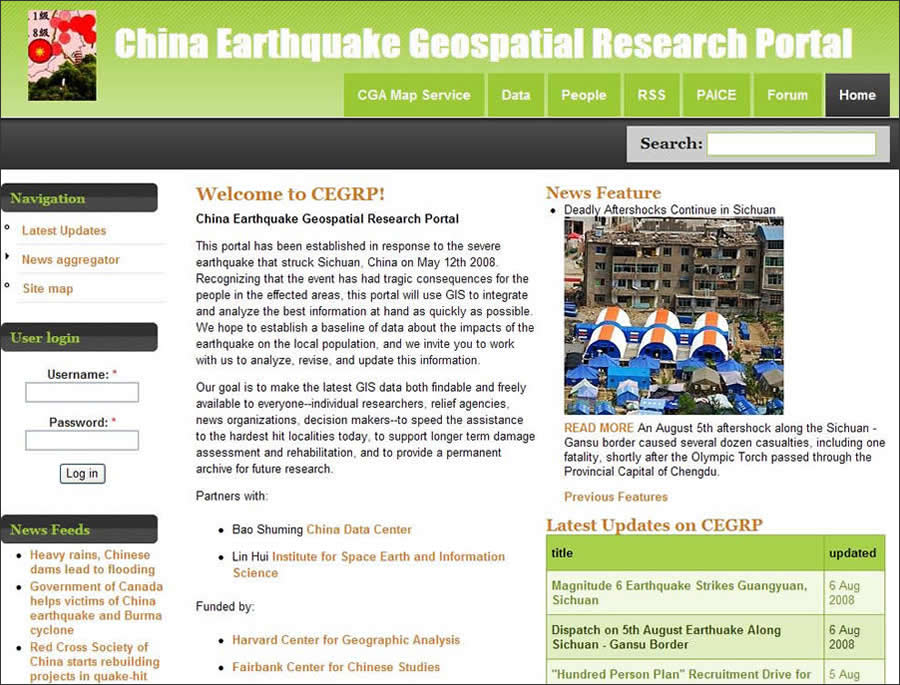 On CEGRP's home page, the public can view or download earthquake-related data. Visitors also can read the latest news about the earthquake and its aftershocks in Sichuan Province and find information related to recovery and reconstruction efforts. Contents are updated frequently by system administrators as well as subscribed members. |
Visitors to the CEGRP site can also visualize data online that's related to the quake by using the China Earthquake Map Service hosted by the Center for Geographic Analysis (CGA) at Harvard.
A Window into a Large Seismic Event
CGA and the Fairbank Center for Chinese Studies, also at Harvard, launched the CEGRP project two weeks after the temblor. Officials at the center and at CGA realized that sharing GIS data would assist organizations dealing with everything from disaster relief to reconstruction efforts. The CEGRP will also help in scholarly research, as the data from such a large and devastating quake will be useful to urban planners, public health workers, environmental scientists, and others studying the seismic event, said Berman. Fairbank Center for Chinese Studies officials agreed that the earthquake's significance from so many standpoints—from the sheer human tragedy to the science of the quake and from what the event will mean for China's economy to what role the catastrophe will play in politics in the future—meant it was worthy of a project to collect and share data about it.
"I think most big events in the news capture people's attention for a short time, and then they fade away," Berman said, but the earthquake "is going to have a large-scale impact on China and its economy for many years."
The CEGRP, funded by CGA and the Fairbank Center for Chinese Studies, will provide scientists, decision makers, scholars, researchers, students, humanitarian and relief organizations, and the news media with access to downloadable and complimentary GIS data, imagery, and other information related to the quake. That data can then be integrated and analyzed using GIS software, leading to a greater understanding of many issues including and involving the following: the seismic activity in China, past and present; the type of damage the earthquake and aftershocks have caused (such as massive landslides and the creation of quake lakes); the economic and environmental impacts of the disaster on the country; the health toll on the residents of Sichuan Province; and reconstruction plans in the devastated areas.
Although the Fairbank Center for Chinese Studies proposed the idea for a research project that focused on the Sichuan earthquake, the CGA is spearheading it.
"They decided the geographic component is the one that ties everything together," Berman said, so the project was turned over to Wendy Guan, research director at the CGA.
"Wendy really wanted to push forward quickly on the geospatial research side," he said, adding that CEGRP will be a smart way to study the Sichuan earthquake and promote data sharing and problem solving, whether it's related to plate tectonics or public health.
"I don't know of any other Web sites that focus on trying to collect data specifically related to the earthquake and deliver it to anybody who is interested," said Berman. "I think it was a good decision to coordinate something that brings together all this information in one place."
 Data collected through the portal is symbolized and served for viewing and investigation through ArcGIS Server. Public users can turn on and off various data layers; search and zoom to places by name; examine population, casualty, quake intensity, and impact zoning; and access local survey maps and other regional or local data. Data visible on this map server is also downloadable from the portal. |
Berman and Guan hope the data sharing will include information from academic and government sources within China. Guan observed that the Chinese government has shown a willingness to accept help from governments and organizations outside the country during the aftermath of this disaster, and perhaps the portal will lead to more international cooperation and data sharing, too.
"Our first objective is to promote information sharing," Guan said, and the second is to "provide access to data that would trigger unique research projects related to the Sichuan quake."
Guan and Berman said those projects might be related to public health such as studying the water quality after the quake; the psychological impact of the tragedy on the survivors; and building codes in quake-prone areas.
Seeking More Data
Almost daily, updates are posted to the CEGRP Web site with links to GIS layers, tabular datasets, satellite imagery, disaster recovery policies, papers related to the quake (including topics such as landslides), announcements of symposiums and calls for papers about the earthquake, and related reports. Although the amount of available data is growing, contributions are continually being sought and include requests for
- GIS layers and datasets related to the earthquake zone
- Photos and narrative documentation of specific sites
- Links to agencies conducting GIS analysis about the earthquake
- Historical and demographic information related to the earthquake region
- FTP files to the CEGRP server for distribution and archiving on the CEGRP portal
CEGRP also posts news articles related to the quake from media outlets such as the New York Times, Reuters, the Associated Press, the Christian Science Monitor, and Xinhua News Agency. "I have several aggregators running that pluck out articles specific to the earthquake," Berman said. Examples include an article published in the International Herald Tribune by Boston Globe writer Drake Bennett, "Do Natural Disasters Stimulate Economic Growth?"
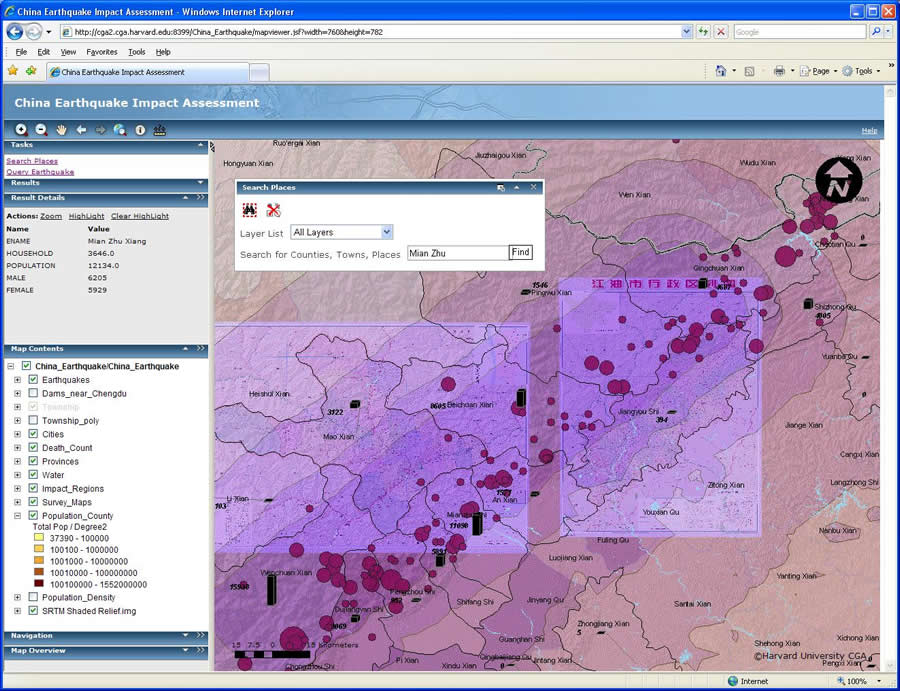
The CEGRP site also includes the CGA map service for visualizing data. Participants can use either the ArcGIS Server or the MapServer version. Berman said the MapServer version is basically a data browser. The datasets on the CEGRP have been loaded into the ArcGIS Server version of the map service, which offers a lot of functionality. The ArcGIS Server version allows end users to turn GIS layers off and on, search and zoom by place-name, query epicenters, investigate population and other attributes, and overlay county survey maps for selected counties, Guan said.
Register to participate in the CEGRP project. For more information about CEGRP, contact Merrick Lex Berman (mberman@fas.harvard.edu), or Wendy Guan, research director, CGA (wguan@cga.harvard.edu).