Live on Everest Web Application Shares a Teenager's Amazing Journey
By Susan Harp, Esri Writer
Many dream of conquering Mount Everest, known in Nepal as Sagarmatha, or "goddess of the sky." Some climbers reach the lofty goal and—for a few minutes, at least—stand victorious atop the 29,035-foot mountain. But very few are able to take a global audience with them, as 13-year-old Jordan Romero did.
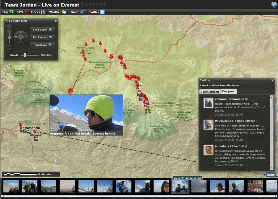 The application brought the conversation about the climb on Twitter into view. |
On a clear night in May 2010, in subzero temperatures, Jordan started his final, 26-hour leg of the steep and dangerous climb up Everest. The boy from Big Bear Lake, California, was on his way to becoming the youngest person ever to scale the world's highest summit.
Around the world, followers kept tabs on Jordan's journey via Live on Everest, a Web application provided by Esri. They were glued to a digital map on their computers as they watched a trail of red dots ascend the northeast ridge of Mount Everest—each dot marking his progress in 10-minute intervals. A circle that pulsed softly, like a heartbeat, reported each new location. Superimposed on the map were live Twitter exchanges from the members of Team Jordan, including Jordan; his father, Paul Romero, and stepmother, Karen Lundgren; and guides Ang Pasang Sherpa, Lama Dawa Sherpa, and Lama Karma Sherpa, as they closed in on the summit.
Back in the small community of Big Bear Lake, cheers erupted inside the home of Naomi Nelson, a schoolmate of Jordan's who was following the dots on the map with her family. At 9:45 a.m., Everest time, on May 22, she saw the red dot pulsating from the peak and knew Jordan had bagged his dream. "I watched him on the map with my parents and sisters, and when he made it to the top, we went crazy," says the seventh grader. A host of others watched, too. Hits on Live on Everest skyrocketed to 18,000 on that record-breaking day.
"I know technology is saving lives every day, and in this case, it did make our team safer and [keeps us] in contact with rescue and even friends and family," says Jordan about Live on Everest after returning home in June. "Feedback was just unbelievable. We were praised as likely having the most professional and most-watched expedition ever on Mount Everest."
Team online submissions recorded the group's travel experiences. Tweets and photographs captured the initial excitement as Jordan explored the streets of Kathmandu, Nepal. Then the subject turned to safety equipment and food supplies. On the mountain, Jordan wrote about the three Sherpa guides as well as the cook, Kumar, saying "Kumar's kitchen.[is] not glamorous, but it's amazing." Then the mood turned serious as team members attended a traditional climbers ceremony to pay homage to the mountain before beginning the dangerous ascent. Individuals in the posted photos then became unrecognizable under giant parkas, hats, gloves, and goggles; eventually, oxygen masks were added, and the Tweets became shorter and less frequent as the climbers headed for the summit.
Using a Mapcentric Interface
The Live on Everest application used Esri ArcGIS technology to bring various types of online information together into one simultaneous view. In addition to showing the map with nearly live tracking and Twitter exchanges, the application aggregated and displayed social media information from the team's Facebook blog and Flickr photos. Visitors at Live on Everest could access local weather forecasts, explore a terrain profile that calculated daily distance and elevation gains, and see a side view of the climbing route.
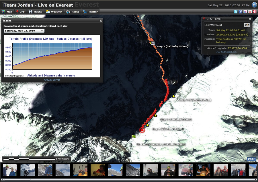 Live on Everest visitors were able to explore a terrain profile that calculated daily distance and elevation gains by Jordan and his team. |
"It was a fascinating feeling to be so remote, so disconnected, yet having the whole world watch our every move," Jordan says. "Having family and fans connected to us provided energy; it provided pride to another level about our quest. Pretty cool stuff, almost like being on the moon and having so many people watch our every move."
Jordan and his team had not only planned every step of the climb but also ensured that anyone with an Internet connection could visualize their journey. They carried some of the technology with them: a SPOT Satellite GPS Messenger location receiver and transmitter, satellite mobile phone, and notebook computer along with solar technology for recharging batteries. Throughout the journey, the ArcGIS application, hosted by Esri, provided the platform to combine maps, satellite images, geolocation, and social media in a single, online viewer.
"I congratulate Jordan on achieving his goal," says Esri president Jack Dangermond. "Esri appreciates having the opportunity to contribute by helping Jordan communicate his entire journey to the global community."
Team Jordan originally envisioned using a live mapping application and, having heard of Esri, contacted the company to help make it a reality.
"The Esri platform integrates well with online services and social media and can quickly provide map and satellite images at any scale," says Randy Frantz, Esri manager for the telecommunications and location-based service industries. "The application provides a mapcentric interface that brings everything that's relevant together. It gives the viewer the ability to quickly understand what is going on."
Frantz worked with the application team of Allan Laframboise and Andy Gup, both Esri Developer Network technical leads, to launch Live on Everest.
"It's an excellent example of how GIS services and social media can be combined to build the next generation of geolocation applications," says Laframboise. "We have seen how using social media and geolocation has helped in situations such as the Gulf of Mexico oil spill. With the increased availability of location-aware platforms and devices, now even on cell phones, I think this is just the beginning of a new frontier of GIS software development."
Developing the Application
In just three weeks, the technical team members implemented the Esri ArcGIS platform to support the project. They used Esri's ArcGIS Server to automate a number of back-office operations, such as acquiring and storing the team's geolocation and social media data. They used a combination of Esri server, online imagery, and desktop technology to create, author, and publish the location data and related information as geospatial services. The back end of the system was fully automated, so Team Jordan members could use GPS equipment and social media technology as they normally would without having to carry out additional software tasks to keep their locations tracked on the Web site. "The overall goal was to build a near real-time application so they could share their experience with the world," says Gup.
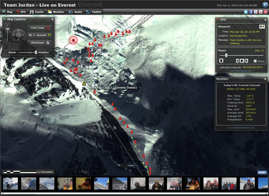 The application also displayed the latest weather forecasts for Mount Everest. |
This was accomplished with the ArcGIS API for Microsoft Silverlight/Windows Presentation Foundation (WPF), which provides the mapping interface that delivers live information from Web services such as Twitter. The API enables the creation of rich Internet and desktop applications that use the powerful mapping, geocoding, and geoprocessing capabilities provided by ArcGIS Server and Bing Maps services. Esri offers three ArcGIS APIs—for Silverlight, Flex, and JavaScript—that allow developers to quickly build geoenabled Internet applications and embed them in Web pages.
For Live on Everest, the ArcGIS API for Microsoft Silverlight/WPF helped viewers automatically navigate to the team's last reported GPS position and simultaneously see what Team Jordan and others were saying on social networks. It also added the educational components such as weather forecasts and a terrain model.
The result was a viewer that could bring Team Jordan into numerous school classrooms and living rooms, not to mention help comfort family members back in California.
Says Jordan, "Perhaps through this technology, I'm actually going to inspire some kids to get out and set some big goals and dreams."
Indeed, Jordan's own schoolmates checked on him every day via the Web. Jennie McCoy, seventh grade history and English teacher at Big Bear Lake Middle School, projected Live on Everest on a big screen each morning. She used the opportunity to discuss how making and staying with goals can lead to success. "The students watched as someone they actually knew set a very big goal and accomplished something really amazing," McCoy says.
McCoy's student Naomi Nelson reports that although she does not aspire to climbing a mountain, "If Jordan can climb Everest, then I know if I start something I can finish it, like becoming an ultrasound technician or trying to be so good at soccer that I am chosen [as] most valuable player."
Jordan's journey began at age 9. He was inspired to climb the Seven Summits, which comprise the tallest mountain on each of the seven continents, after he saw a school mural of the summits. With his parents' support, Jordan started at age 10 by climbing Mount Kilimanjaro in East Africa. He then climbed, in order, Mount Kosciuszko (Australia); El'brus (Europe); Aconcagua (South America); Denali (North America); Puncak Jaya, also known as Mount Carstensz (Indonesia); and Mount Everest (Asia). (Because Mount Kosciuszko and Puncak Jaya both lay claim to the Australian continent record, one must actually climb eight peaks to cover the two divergent lists.) In December 2010, Jordan intends to become the youngest person to have climbed all eight when he tackles Antarctica's Mount Vinson.
To learn more about Jordan and his Everest summit, visit www.jordanromero.com, where you can click Live on Everest (http://edn1.esri.com/everest/default.html) to see the map.