ArcWatch: Your e-Magazine for GIS News, Views, and Insights
September 2011
GIS-Based Tree Inventory Makes Strolls through San Francisco Botanical Garden Safer
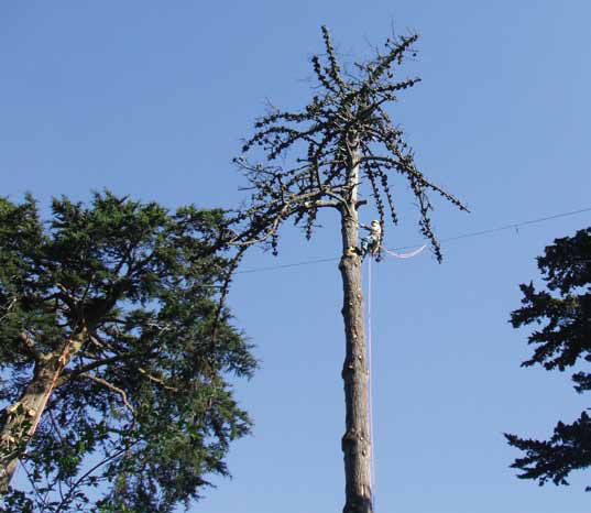
An arborist from Bartlett Tree Experts removes a dead Monterey pine at the San Francisco Botanical Garden.
A GIS-based tree maintenance inventory helped make a park in San Francisco safer.
An impressive canopy of pine, cypress, and gum trees offer shade and beauty for people strolling through the San Francisco Botanical Garden at Strybing Arboretum. The garden, which lies within Golden Gate Park in San Francisco, California, is a 55-acre horticultural refuge that houses plant collections from other parts of the world, such as Chile and Australia.
But on a walk through the garden, an anonymous donor recognized the potential risks the maturing trees posed to visitors. Some trees were overgrown or dying. Branches could fall and injure someone or damage the property during a bad storm.
Throughout the 1,017-acre park, which was developed in the late 1800s, large maturing trees, such as Monterey pine, Monterey cypress, and blue gum, were planted to secure what was then the sand dunes that made up the western part of the city. But many of these giant trees eventually contained large dead limbs or other structural defects, which predisposes the trees to branch, stem, or root failure.
Coordinating with the San Francisco Botanical Garden Society, the donor provided the funding to tackle this large problem. Bartlett Tree Experts, based in Stamford, Connecticut, with research laboratories in Charlotte, North Carolina, was called in to conduct a tree inventory and trim or remove trees that could cause injuries if they fell. Upon touring the garden for the first time, Bartlett's representatives knew that hundreds of hours of work would be needed to complete all the required tree pruning, support system installation, and removals. A tree inventory was needed to properly plan, organize, and prioritize the work.

GIS integrates the many tasks involved with tree care inventory and management.
Inventorying Trees
One of Bartlett's many services is conducting GIS-based tree maintenance inventories. Its staff worked with garden personnel to define the goals and objectives of an inventory of the arboretum. The inventory was conducted on all trees 18 inches and larger in diameter at four and a half feet above ground level or any tree that showed visual evidence that it may fail. Using Arborvue, a GIS software solution built with Esri's ArcPad and ArcGIS Engine, tree attribute information, such as tree species, diameter, and health, was recorded along with recommendations for improving tree stand health and structure, such as pruning, structural support system installation, or tree removal.
Recommendations would be prioritized while in the field using a visual risk rating system. Additional tree evaluations were recommended when it was difficult to tell from the ground whether a defect in a branch or stem warranted abatement.
Two inventory teams were formed from a group of GIS support specialists/International Society of Arboriculture (ISA)-certified arborists from Bartlett's laboratories; the local Bartlett representative; and a consultant from HortScience, a horticultural consulting firm based in Pleasanton, California. Using ArcGIS, the GIS specialists overlaid a computer-aided design (CAD) drawing of the garden on aerial imagery obtained from GlobeXplorer Inc. (now part of DigitalGlobe, Inc.).
Using the newly created map, the garden area was equally divided among the teams of arborists. Each team used a Trimble GPS/data recorder with a Trimble GeoBeacon to capture all the tree attributes and maintenance recommendations.
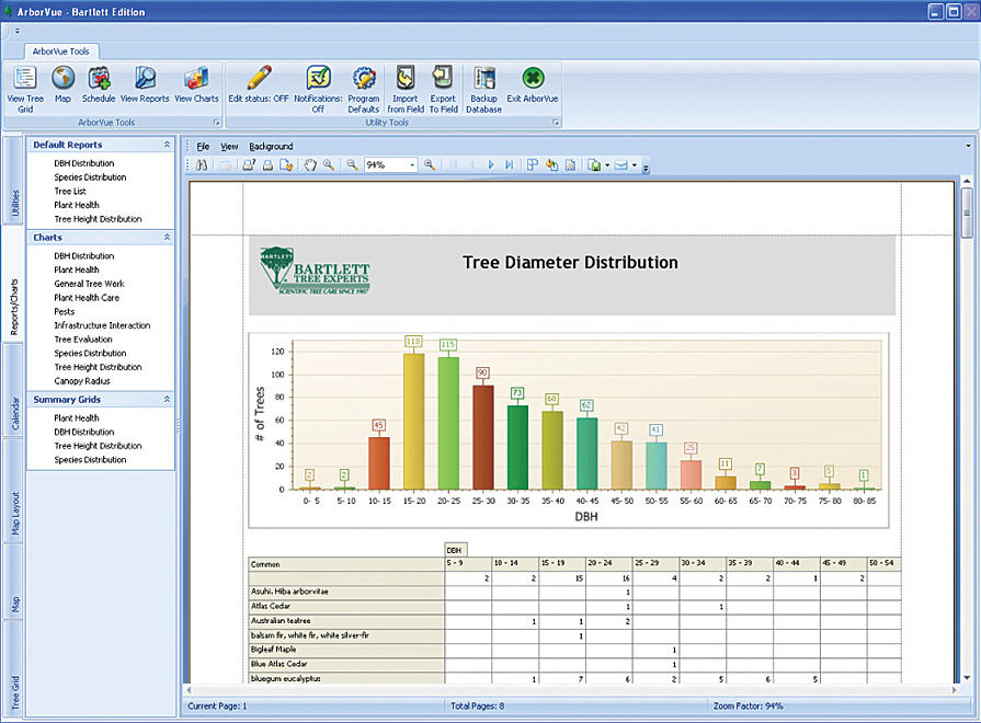
A wide range of reports, charts, and summary information gives the user information about tree metrics and tree care activities.
The tree inventory took one week. In total, the teams captured attributes for 710 trees. Although the majority of the trees were Monterey pine, Monterey cypress, and blue gum, the teams recorded a total of 132 different tree species.
One hundred forty trees needed to be removed because they posed potential hazards or were in advanced stages of decline. In addition, 513 trees needed to be pruned for safety, health, structure, or appearance. Another 47 trees needed tree support systems installed or inspected to reduce branch and crown failure potential.
Thirty-three trees needed to be assessed further to determine the wood's strength. Tree diseases such as pine pitch canker, pests such as stem-boring beetles, and soil conditions were also recorded during data collection to help manage the trees in the garden.
Mapping the Trees
After the field data was collected, a management plan was developed with recommendations for different types of work grouped together and prioritized. The GIS specialists generated maps to illustrate where trees were located, along with the associated recommendations. Further queries were developed and illustrated on maps to show daily progress. As with most large organizations, there were numerous other projects going on at the same time as the tree work. Using GIS developed for the garden, tree work projects could be reprioritized around other projects taking place. Additionally, garden staff made all tree inventory information and maps available to the general public, and 30-day removal notices were posted to diffuse any public concern.
Thirty trees, ranging from 15 to 200 feet in height, were removed at the garden, and 150 trees were pruned or had structural support systems installed. A total of $452,500 was donated and invested in the garden, including the tree inventory/management plan, all the work associated with the pruning and removals, and the tree succession planting plan.
Not long after high-priority tree pruning and removals were completed, a severe storm struck San Francisco. Many trees in the region were felled or badly damaged. Only five trees in the garden were lost or damaged, and these trees were in low-priority areas. Garden officials credit the work prescribed and carried out through the GIS model of the management plan as the reason there was so little damage to the garden compared to the rest of Golden Gate Park.