ArcWatch: GIS News, Views, and Insights
September 2012
Geography: A Platform for Understanding
Geography is our platform for understanding our world. Watch Dangermond's opening talk from the 2012 Esri International User Conference.
You and I live on a small planet. We breathe the same air and are increasingly concerned about the future—our personal future, the future of our families and communities, and even the future of life on this planet. Our world is changing rapidly, with many trends that will challenge you and me for the rest of our lives. At different scales, some of these issues will be especially challenging to us personally and professionally as our organizations face the consequences of these changes.
At the same time, we are living in a time when scientific discoveries and technological advances are accelerating dramatically. We are making huge discoveries, and we're creating unfathomable volumes of data in the process. But data isn't enough. Clearly, we need more integrated knowledge and ways to be able to create better outcomes. We need to harness our technology and our brain power to create a better future.
Geography Comes Alive
Geography is our platform for understanding the world. GIS is making geography come alive. GIS condenses all our data, information, knowledge, and science into a kind of language that we can easily understand: maps.
Maps help us integrate and apply our knowledge. Maps also tell stories—stories about almost everything in our world. Using maps allows us to leverage the power of geography to design the future and create better outcomes.

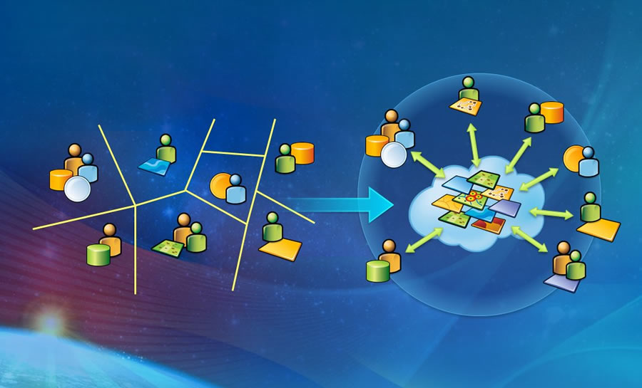
By integrating traditional GIS with a new pervasive world of applications, cloud GIS provides geography as a platform.
I'm very confident that we can do this. One reason is that GIS itself is advancing; it's getting more powerful and becoming easier to use. It's evolving with lots of new capabilities. It's moving to the cloud and becoming more pervasive in broader society. GIS has brought mapping to a new level: creating geography as a platform.
Reimagining Our World
This new platform makes geographic knowledge ubiquitous by connecting traditional GIS with the whole new world of applications and devices. Now, GIS knowledge can be shared with everyone.
GIS also leverages many other technology trends: widespread measurement via the sensor web, big data, pervasive computing, cloud computing, Software as a Service (SaaS) computing, device computing, applications, and the whole world of science itself.
The convergence of GIS with these trends will support the vision of geography as a platform that can empower us to reimagine our world and integrate geographic knowledge into everything we do.
Cloud GIS—the delivery of GIS capabilities on demand as services via the Internet—integrates all types of geographic information: maps, data, imagery, social media, crowdsourced information, sensor networks, and much more. As we continue to "wire up" the world, we can make this information more accessible.
Cloud GIS also enables increasingly widespread access to geographic knowledge; it integrates the traditional work of geospatial professionals with a whole new world of applications. It takes what has been a relatively scarce commodity—geographic knowledge—and makes it abundant. And web maps provide a medium for integration and understanding, making this information widely accessible in simple forms. This widespread, easy access to geographic knowledge is what we mean by providing geography as a platform for understanding.
This new platform changes the discussion, breaking down barriers between different workflows and disciplines.
The New Pattern of Cloud Computing
This new pattern of cloud GIS changes the discussion; it breaks down the barriers between different workflows and disciplines and brings them together too. This will enable us to better collaborate and share as well as approach problem solving and decision making more holistically.
We are already starting to see organizations rapidly adopt this new pattern. The European Environment Agency, World Bank, United Nations Environment Programme (UNEP), and many US government agencies are adopting this pattern, using cloud GIS to support their own missions and at the same time sharing their knowledge. And they are finding out that by sharing their geospatial knowledge in the cloud, they are creating a new kind of spatial data infrastructure.
A Platform for Understanding
Sharing geospatial knowledge is rapidly resulting in geography emerging as a platform. This will open our world and create a new level of understanding. As more organizations embrace this new pattern and adopt a culture of collaboration and sharing, members of the GIS community will benefit greatly. They will be able to do their work better and extend the role of GIS in our organizations.
Our work at Esri is about enabling our users to do their important work. Our focus is on developing and supporting a robust technology platform that supports a wide variety of applications. We take that responsibility very seriously. I want to thank you for entrusting us to do that.