Esri Helps Kentucky Deliver Maps of Abandoned Mines Online
By Matthew DeMeritt, Esri writer
 The Kentucky Mine Mapping Information System (KMMIS) Web site provides The Known Mined Out Extents service, which here shows coal mines in the vicinity of Pineville, Bell County, Kentucky. The shaded polygons represent coal that has been removed. |
Keeping track of abandoned mines is no easy job—especially in a state with more than 30,000 of them. As famous for its rich coal mining history as it is for its horse racing, the Commonwealth of Kentucky launched an ambitious project: The Kentucky Mine Mapping Initiative. This initiative called for digital archiving and public access to all the commonwealth's abandoned coal mine maps. The project's goal is twofold: (1) increase mine safety by giving officials the cartographic information they need to conduct further mining operations; and (2) save mining officials the time and expense of physically retrieving and copying mine maps. To date, more than 20,000 abandoned mine maps have been digitally archived and made available online to the public through the Kentucky Mine Mapping Information System (KMMIS). Esri software was used to digitize the maps and serve them over the Web.
Knowing Where Not to Drill
Abandoned mines pose a serious safety problem in Kentucky. Since coal deposits are concentrated in large areas throughout the state, active mines are sometimes sited adjacent to abandoned mines. The boreholes in these old mines are often flooded with water from previous operations, so mining companies working nearby need accurate location information to prevent accidentally drilling into them and causing a blowout of pressurized water. The likelihood of subsidence (roof cave-ins) also increases near these areas over time, as water seepage from flooded boreholes makes the earth heavier and less stable. In short, having maps of these abandoned mines helps protect miners and reclamation personnel from these dangers.
Archiving and Serving the Maps
Until a few years ago, abandoned mine maps in Kentucky existed only in paper form. The Kentucky Office of Mine Safety and Licensing (KOMSL), the main depository of these maps, had the largest storehouse of abandoned mine cartography in the world. With more than 160,000 mine maps, it's little wonder that the office, with help from the Kentucky Department of Natural Resources (KDNR), decided to digitally archive the collection so that mining officials and the public could finally have easy access to them.
The process of archiving Kentucky's mine map collection varies from map to map. Some maps are simply scanned and archived into a database while others are given a more detailed treatment by georeferencing them in a GIS software environment. "First, we scanned the map using a 42-inch-wide digital scanner," says Thomas Schubert, Environmental and Public Protection Cabinet (EPPC) contractor at KOMSL. EPPC is the state cabinet responsible for the protection and preservation of Kentucky's air, land, and water resources. "From there, we import the file into an image program to crop and rotate as necessary. A CAD application is used to register each map and assign the x,y values in the image to a state plane or Universal Transverse Mercator (UTM) coordinate system." The map team used raster data in ArcMap to align the TIFF file and convert it to a geoTIFF file (geoTIFF is a public domain metadata standard that allows georeferencing information to be embedded within a TIFF file).
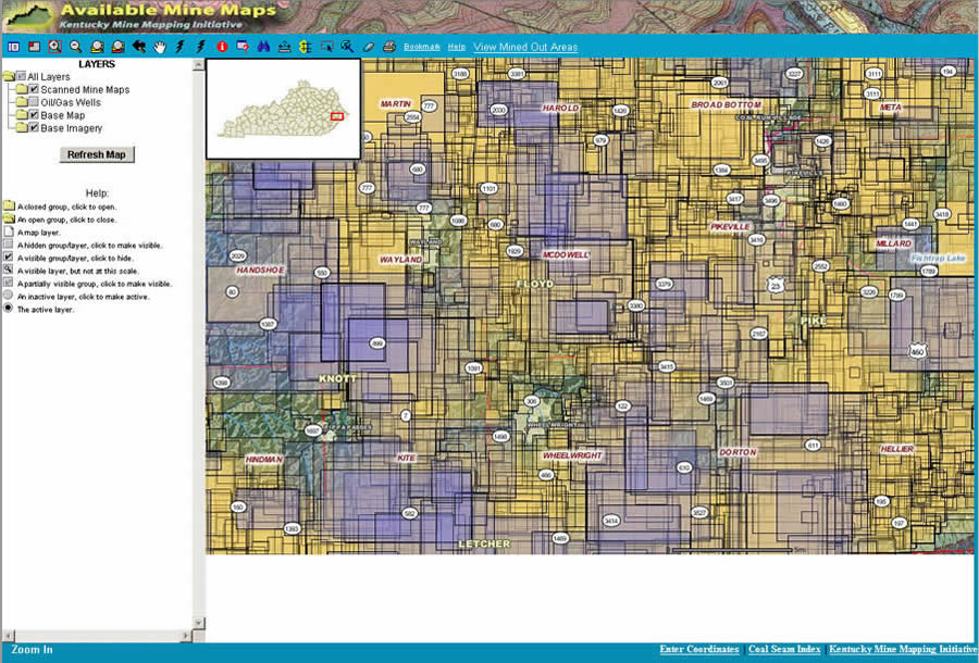 The Available Mine Maps service from KMMIS shows the mine map documents scanned in Floyd County, eastern Kentucky. |
ArcIMS is used to serve the map data to KOMSL's customers via the interactive map site at KMMIS. "The whole concept of GIS is that people no longer have to look through textual tables containing disparate data and put it all together," says Bryan Bunch, IT systems consultant at KOMSL. "ArcIMS gives our customers a graphic interface to locate and zoom in to these maps." Bunch also used ArcInfo and ArcObjects to write specific tools for the project. Prior to Kentucky's map digitization project, mining engineers had to travel to the map warehouse at KOMSL and hand select the maps they needed. Once they chose their maps, they had to make copies at the local blueprint copy facility. Since the office is in central Kentucky, the entire process could take as long as two days for engineers who traveled from the eastern- and westernmost parts of the state. "Miners used to have to make long trips to obtain the information they needed. Now that the information is online, they can just download and print the map at their location," says Schubert.
Digitizing the maps also made it convenient for coal companies, which only have to submit one map annually to KOMSL. This is because state and federal agencies are able to access the maps from the online information system. Before the Kentucky Mine Mapping Initiative, coal companies had to submit as many as five paper maps per year to several different agencies.
Putting the Maps to Use
The mine map Web site has already proved helpful to agencies that regulate mine safety. In 2006, the Kentucky Division of Emergency Management simulated an earthquake that "sealed" an underground mine in Muhlenberg County. Using maps from the mine mapping site, GIS specialists from Kentucky were able to identify the opening to the mine and see a detailed layout of the site during the exercise. One of the three large screens in the Emergency Operations Center continuously displayed information from Kentucky's mine mapping site throughout the drill.
In 2005, a mine blowout flooded part of Highway 80 in Knott County. Using a map downloaded from KMMIS, the field inspector was able to immediately identify the exact location where the blowout occurred. From there, he relayed location, mine seam, and coal company information to his superior by cell phone. Other surface mine inspectors were equipped with a printout of the mine map when they arrived at the blowout site later that day.
The maps are not only useful to emergency responders and mining officials but to homeowners and landowners as well. Often, citizens decide to build on land that is on top of or downstream from an abandoned mine. As a result, property near these sites becomes vulnerable to the effects of subsidence and blowout, which have been known to obliterate neighborhoods and disfigure acres of land. According to the KMMIS Web site, the need for a comprehensive and accessible archived mapping system for the locations of Kentucky's underground and surface mines was reinforced by such an incident. On October 11, 2000, a slurry impoundment in a Martin County coal mine suffered a crack, releasing a torrent of noxious sludge into downstream communities and adjacent creeks. Although no lives were lost, the environmental impact and havoc that it visited on residents were extensive. The value of KMMIS is that citizens can now be more informed about the land on which they plan to build or currently reside.
A Web Hit
The demand for easily accessible abandoned mine cartography is evident from the 600,000 hits the Web site receives monthly-a number that is steadily increasing. KMMIS is the number one search result for people who type "mine maps" into the Google search engine, a fact that John Hiett, program manager for KMMIS, says reflects the project's success.
"The volume of hits that the Web site gets shows the enormous demand for online access to maps," says Hiett. "All we did was create the Web site and before we knew it, we were number one on Google for people looking for mine maps." KDNR's goal is to eventually digitize the entire collection and continually update the system with new mine mapping information. For more information about KMMIS, call Hiett at 502-573-0140 or e-mail him at john.hiett@ky.gov. To access mine maps at KMMIS or learn more about the project, visit http://www.minemaps.ky.gov/.