Streamlining Government from the Ground Up
By Karen Richardson, Esri Writer
Managing assets efficiently can make or break an organization.
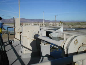
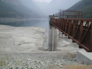
 The Bureau of Indian Affairs uses GIS to help manage assets such as the Colorado River Irrigation Project in Arizona. |
Deploying field crews requires good organization and planning. Correct locations of assets need to be known and parts must be available. The Bureau of Indian Affairs (BIA) understands this well. The BIA maintains 16 irrigation projects and 100 smaller systems on tribal lands spread across 66 million acres in the Great Plains and Rocky Mountains as well as in the northwest, western, and southwestern regions of the United States.
With 100,000 assets such as dams and irrigation ditches dotting a vast landscape, the BIA Division of Irrigation, Power, and Safety of Dams (IPSOD) field crews face the challenge of simply finding assets. Dispatching crews across these regions and not knowing the exact location of each asset can pose a real problem. Locating each structure can be time-consuming, turning into a bigger expense than originally planned.
Using GIS to Protect the Bottom Line
To help crews locate assets easily, IPSOD decided to use GIS software to create a system that would help workers in the field find the assets, access all open work orders, and update information. IPSOD had been using IBM's Maximo asset management software to schedule and view work orders and tasks. Maximo lets users see resource requirements in a Gantt chart, a type of bar chart used in many organizations to illustrate project schedules and ensure efficient work planning.
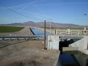
 Water flow at the Colorado River Irrigation Project in Arizona is controlled by head gates on main laterals, servicing farmland from the main irrigation channel. |
"So our field staff could more easily find assets, especially those with no street addresses, we were interested in including maps with work orders," says Assad Reichdan, IPSOD's technical program manager. The first step in adding maps to manage work orders: record the location of the assets. In 1999, IPSOD started to send workers out to the field with Global Positioning System (GPS) units to collect each structure's location data. Collecting and processing the data took five years. Although it was a significant investment of time and money in the beginning, the data now only needs to be maintained and updated during the life of each asset.
Next, IPSOD created a mapping interface to IBM's Maximo using Esri's ArcGIS. This was an easy and economical decision for the federal bureau, since the BIA had an enterprise license agreement (ELA) for Esri software. This decision ensured IPSOD would be able to interface with other systems throughout its own organization as well as federal organizations that also use Esri technology.
Adding Mapping Functionality to IBM's Maximo
The bureau created a software solution called the BIA IPSOD Asset Map Viewer, a customized interface to ArcGIS Desktop, which functions as a master asset repository. About 200 employees nationwide use the application through the BIA intranet. Along with providing maps to crews dispatched in the field, Asset Map Viewer serves as a central integration point to other systems at the BIA. This makes the preparation of federally required documents needed for managing assets much easier. Data can be accessed and used for the deferred maintenance report, an annual disclosure required by a nine-member board established by the U.S. Secretary of the Treasury; the Federal Real Property Profile report, which is necessary for the federal government's inventory of land, building, and structure assets around the world; and as an image repository.
Workers already familiar with the BIA computer network easily understand the system because the interface was created to look similar to other popular Web applications. A worker begins by first opening the main map viewer window. No login is required since security is integrated with Active Directory, a Microsoft networking service that allows the BIA administrators to manage the system and various levels of security. An access control list (ACL) notes locations of sites and the assets IPSOD manages that are available to each user.
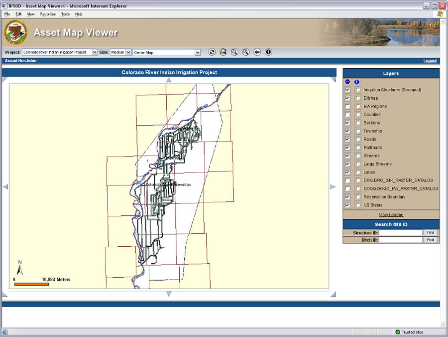 The Bureau of Indian Affairs uses ArcGIS Server from Esri to provide the information that's used to locate and maintain more than 100,000 assets for 16 irrigation projects and 100 smaller systems on tribal lands. |
Once in the system, workers can apply the map viewer to zoom to the assets that they select. Assets are selected by either searching the map or using a text search engine. Buttons on the map are used to easily display information from all the integrated applications. From this map viewer, workers can access photos, deferred maintenance data, and Maximo information including work orders. Adding maps to Maximo with ArcGIS has resulted in dispatching field-workers more efficiently and ensuring supplies are available for infrastructure maintenance. Less time and fewer resources are required to find assets across the various regions, resulting in saving money on maintenance project work.
Collaboration between Government Agencies
With these successes in mind, the BIA is now upgrading to ArcGIS Server from ArcGIS Desktop to take advantage of the geodatabase for storing the bureau's large volume of infrastructure and asset data. While the BIA has used Maximo for many years and understands the software well, the bureau turned to another federal organization for assistance in implementing server GIS: the U.S. National Park Service (NPS). The NPS, like the BIA, which is under the jurisdiction of the U.S. Department of the Interior (DOI), uses Esri's ArcGIS Server to map and maintain assets on its lands.
The NPS's Resource Information Management Division (RIMD) has been working with the Park Facilities Management Division (PFMD) to collect geospatial and digital image data of NPS facilities since 1999. NPS created an application called NPMap that overlays NPS geospatial data and imagery, roads, and cultural basemaps. NPMap is integrated with other NPS systems including the List of Classified Structures (LCS); Archaeological Site Management System (ASMIS); and NPS Focus, a digital library and research station maintained by NPS.
Collaborating made sense between the BIA and NPS since both organizations maintain a vast infrastructure on millions of acres. As an added bonus, the organizations' GIS groups are located in the same city: Denver, Colorado.
NPS and the BIA representatives met at the 2008 Esri International User Conference (Esri UC) in San Diego, California, and began to talk about how their respective workflows could benefit each other. During the meetings, both organizations' asset management solutions were discussed. "We realized NPS was further ahead of us in implementing the ArcGIS Server technology, but we were ahead in integration, specifically with Maximo," says Reichdan.
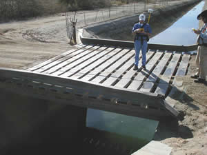 Field crews maps assets at the Colorado River Irrigation Project. The location of each irrigation project and other systems were recorded using GPS. That data and other information is now available to about 200 BIA employees through the BIA IPSOD Asset Map Viewer. |
While NPS has developed and implemented a solution using the latest Esri server and Web technology, the BIA IPSOD has successfully integrated ArcGIS with Maximo. Working together, the DOI departments can help bridge gaps in software integration and realize benefits across the organizations. Relying on each other's technical capabilities, both organizations benefit from the integration of ArcGIS Server and Maximo for managing their infrastructure assets.
GIS for Good Government
Since first collecting geospatial data five years ago, the BIA has benefited from integrating GIS into its asset management software. As a U.S. government agency, the BIA tries to be careful when making decisions about how to spend taxpayers' money. By creating the IPSOD Asset Map Viewer, the BIA has saved money that would otherwise have been spent on upgrading the department's infrastructure such as adding more and new computers and external disk drives to house the vast amount of data and images at each desktop. With the IPSOD Asset Map Viewer, staff members only need to log on to the Intranet from their existing computers to access and use asset information.
 The gatehouse containing controls and power sources at the Jocko Lake, Flathead Irrigation Project in Montana. |
Workers accessing open work orders and updating data in the field have not only increased the efficiency of the organization but the accuracy of the data. The ability to query work orders on a map and return lists of required equipment that are near each other saves time and money when dispatching crews. Being able to query and see location, type, status, history, and concentration of work orders on a map makes management easier. Time-stamped images can be linked to asset locations to better evaluate repairs and current conditions without repeated and expensive field visits. Service schedules are more efficiently prioritized by the ability to query the inventory database and see the assets. Visualizing data across the department has standardized the information and makes annual and comprehensive five-year reporting more accurate.
Maps for the IPSOD crew, either printed or loaded on personal digital assistants, show optimized routes to the day's work and display any safety or hazardous material locations or concerns within a certain proximity of the assets. Using GIS in the field allows service crews to record new repair needs that are seen in the field.
"It has been a common theme in the data analysis world that spatial data will be as common as text data," says Reichdan. "By enhancing our facilities management with GIS, we have seen the value of using spatial data. We want to be at the forefront of this innovation."
Visit www.esri.com/fm to learn more about GIS for facilities management, read case studies and success stories, and explore resources.