ArcWatch: GIS News, Views, and Insights
October 2010
Conserving Earth's Gentle Giants
Save the Redwoods League Maps the Future of Important Ecosystem
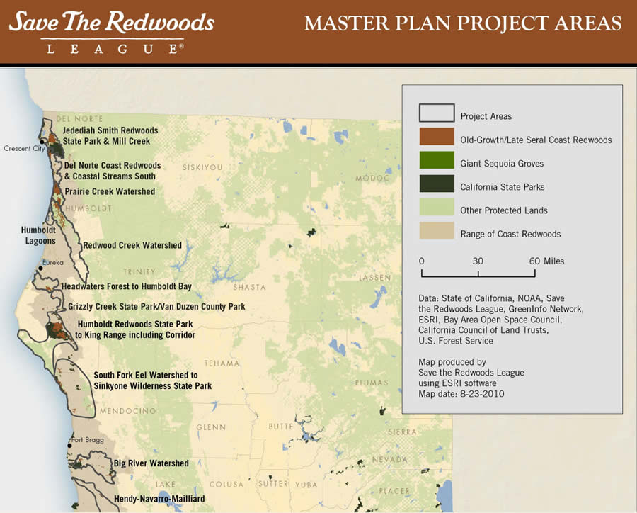
This map, created using Esri's GIS software, shows where the Save the Redwoods League is focusing some of its efforts to save the ancient trees. Map courtesy of the Save the Redwoods League.
To help protect these majestic trees, the oldest of which dates back 2,200 years, the Save the Redwoods League buys land in northern and central California, where the coast redwoods grow. In the past, the league bought land based in part on recommendations from concerned citizens who wanted a particular piece of land protected. But it was hard to know the entire picture based solely on word of mouth.
Today, the Save the Redwoods League uses maps, scientific knowledge, more than 90 years of experience, and the latest technology—including geographic information systems (GIS)—to create detailed regional conservation strategies for redwood forests, parks, and connecting landscapes. Much of the land purchased and protected now lies in Humboldt Redwoods State Park and Redwood National and State Parks, along the coast of Northern California. (See a list of acquisitions). Many of the league's conservation efforts would not have been possible without GIS, which is used to analyze data about the redwoods, development, nearby watersheds, and rare plants and endangered animals in those areas.
The size of the redwood forests began shrinking in the late 1800s during the logging boom. In 1850, there were two million acres of ancient coast redwood forests in California. Today, fewer than 120,000 acres of these old-growth forests remain, having fallen victim for years to unsustainable logging practices, urbanization, poorly planned development, and road building. Climate change is another concern, and the league hopes to answer how it might affect the health of redwood forests and giant sequoias through its $2.5 million research project called the Redwoods and Climate Change Initiative.
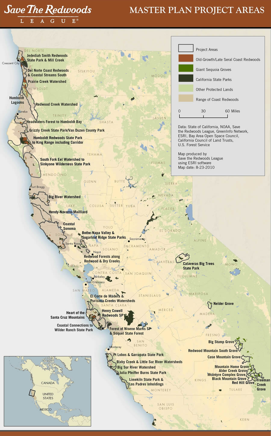
Save the Redwoods League delineated 35 project areas in which it will focus its land protection efforts. This will include the range of both coast redwoods and giant sequoias. Map courtesy of the Save the Redwoods League.
Since forming in 1918, the California-based nonprofit organization has purchased more than 189,000 acres for preservation, including land that contains giant sequoias. Some of the acreage is upstream of coast redwood forests, which is important to preserve from a watershed standpoint.
League Launches Master Plan
To strategically guide, prioritize, and focus its land protection efforts, the Save the Redwoods League launched the Master Plan for the Redwoods in the late 1990s. As part of this plan, the league used GIS models to identify areas that are important to protect.
The models incorporated data on the locations of trails, ancient redwoods, existing parks, and habitat for imperiled and sensitive species such as the Coho salmon, steelhead, northern spotted owl, and marbled murrelet. The data also included threats to the forest, including residential development, land conversion to vineyards, road building, and incompatible forestry practices, plus many other criteria.
The league wants people to experience the redwoods, so if an area contains features that encourage people to visit the majestic trees—such as good hiking trails or beautiful scenery—the area is given a higher rank and has a better chance of receiving public support to protect it. Based on these conservation models, the data is then analyzed using Esri's ArcGIS software, and maps are created and used throughout the organization for deciding which parcels of land to try to acquire, fund-raising appeals, outreach, and resource management.
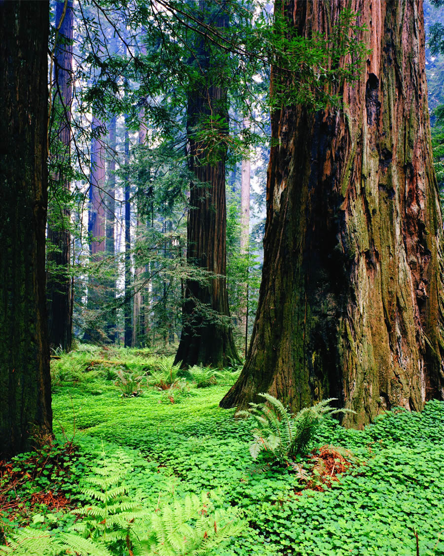
Light filters through this old growth coast redwood forest. Photo by Howard King.
Access to accurate data is crucial for the league's GIS analysis and mapping. Data comes from public agencies such as the California Department of Fish and Game, California State Parks, the National Park Service, and the U.S. Forest Service.
Laura Kindsvater, senior conservation planner at the Save the Redwoods League, said the GIS data used in analyses includes
- Rare and sensitive species such as the northern spotted owl, Pacific giant salamander, Sonoma tree vole, and Humboldt milk vetch
- Fish streams that provide habitat to the threatened or endangered Coho, Chinook, or steelhead
- The U.S. Forest Service's existing vegetation data depicting where mature second-growth forests occur
- Habitat model data for wide-ranging species such as the mountain lion, Pacific fisher, and other forest carnivores
- Projected development, roads, and timber harvest plan boundaries
"Combining and analyzing this data using ArcGIS allows us to visually determine which areas are most important for protection, and we can then act on this newfound knowledge made possible by Esri GIS technology," Kindsvater said.
GIS Helps Identify Land to Purchase
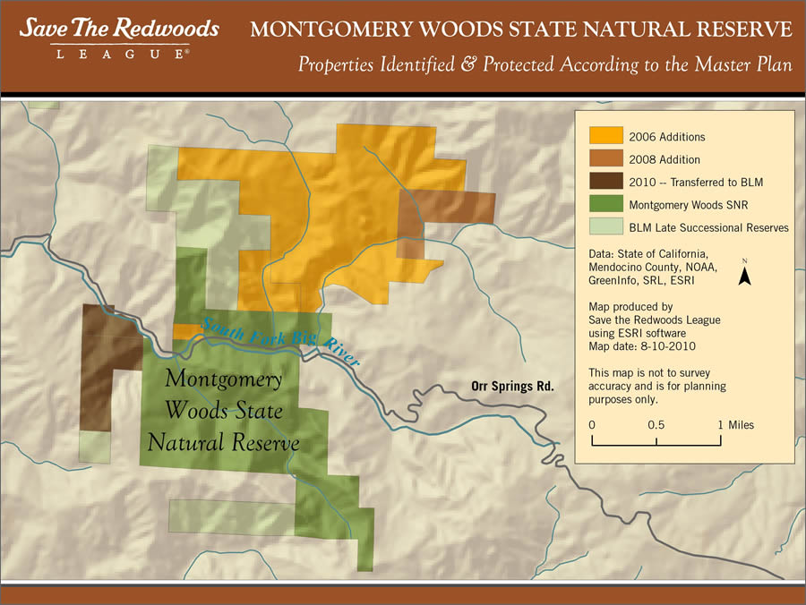
The Save the Redwoods League has been protecting land in Montgomery Woods State Natural Reserve in Mendocino County, California, since the state park was founded in the 1940s. In 2006, the league doubled the park's size by purchasing and adding parcels that contained old-growth Douglas fir forests and rare oak woodland habitats. In 2008 and 2010, the league added more land to the reserve to increase protection of the watershed. Map courtesy of the Save the Redwoods League.
By using GIS software to assist in creating the master plan, the Save the Redwoods League has identified land across the entire range of coast redwood forests in California, down to the property level, that ranks high for protection. Based on GIS analyses, the league has created detailed regional strategies that outline land acquisition goals. Now that the league has completed the detailed regional strategies, the organization will implement the master plan and contact owners of land that received a high rank for protection in areas such as the Santa Cruz Mountains, Humboldt and Del Norte counties, coastal Mendocino and Sonoma counties, and the San Francisco Bay area to find out if they are willing to sell their land or work together on a conservation agreement. (An example of a conservation agreement is when landowners donate or sell the right to develop their land to the league while continuing to own the property.)
GIS is also helping the league discover more about important ecological characteristics specific to the site of the lands it is working to protect so that it can build a case for the property. For example, when the league was raising funds to purchase land to add to Montgomery Woods State Natural Reserve in Mendocino County, it used GIS in combination with fieldwork to find out what types of vegetation grew on each piece of property and which of these were rare and targeted for conservation statewide.

This property was purchased by Save the Redwoods League and added to Montgomery Woods State Natural Reserve in 2008. Photo courtesy of Save the Redwoods League.
Several of the properties include native grasslands and Oregon white oak forests—both a high priority for acquisition by state natural resource agencies. GIS was also used to better understand how each parcel contributes to better protecting the surrounding Big River watershed, as well as the good health of steelhead populations within the watershed and downstream of the properties. In the 1960s, several large floods in Humboldt County caused massive erosion that began in logged areas upstream, inflicting heavy damage to old-growth forests downstream. Since then, the league has been committed to protecting redwood ecosystems at a watershed scale.
"We have been able to identify, using GIS, 35 project areas across the State of California that are a priority for protection," said Kindsvater. "Focusing on these project areas allows us to be much more effective as an organization in protecting the last remaining groves of old-growth redwoods, building the viability of parks and reserves, and maintaining and restoring connecting landscapes."
Sixteen of the 35 project areas have been identified as high priority to purchase and protect, allowing the league to further focus its energy. For example, the Coastal Sonoma project area in Sonoma County, located to the west and northwest of Santa Rosa, has been identified as high priority. Sonoma County has a wealth of incredibly beautiful redwood forests, a low percentage of currently protected lands, significant groves of old growth that remain unprotected, and a high potential to provide inspiration and recreation for millions of people who live less than two hours away.
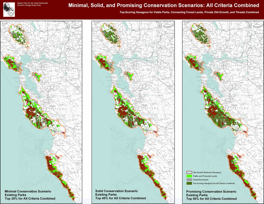
As part of its master plan for the redwoods, the Save the Redwoods League developed a GIS-based, multivariate framework that identified lands most important to protect for parks, connecting landscapes, and old-growth redwood forests. Pictured here: dark green—top-scoring hexagons for all variables in the framework combined; light green—existing protected lands; dark red—hexagons with old-growth coast redwood forests. Map courtesy of the Save the Redwoods League.
Yet these old-growth stands are also threatened by a rapid growth rate in population throughout Sonoma County. Through the master plan, the Save the Redwoods League has learned that there are important lands in the coastal Sonoma region to protect and that the organization must act now to conserve them. It has therefore been investing a great amount of time, energy, and resources in increasing land protection in this region over the last several years, culminating in several large land purchases such as the Jenner Headlands and Stewarts Point acquisitions.
"GIS has made it possible for us to conserve and restore redwood forests in a much more powerful and effective way," said Kindsvater. "Save the Redwoods League will continue to use GIS to update and improve implementation of the Master Plan for the Redwoods, as well as to gauge our success in meeting land protection goals."
By combining a passion for conservation and an understanding of GIS and technology, the league is at the forefront of the battle to protect redwoods and has ensured that redwood forests have a bright, tall future.
For more information or to receive monthly e-mail updates, visit SaveTheRedwoods.org.