ArcWatch: Your e-Magazine for GIS News, Views, and Insights
October 2011
Power for the People
Nova Scotia Power, Inc., Updates Electric Distribution Model Using Mobile Technology and GIS
Nova Scotia Power, Inc. (NSPI), recently launched a three-year GIS Connectivity Project to create an accurate digital representation of its expansive electric distribution system. Data collected using mobile devices and web-enabled GIS software will replace the current models, which are based on original design sketches. So far, the project is saving time and reducing costs while helping the utility create a foundation for improved customer service. Nova Scotia Power, Inc., manages $3.5 billion worth of generation, transmission, and distribution assets across a 15,500-mile system. The system serves nearly a half million residential, commercial, and industrial customers throughout the Canadian province of Nova Scotia.
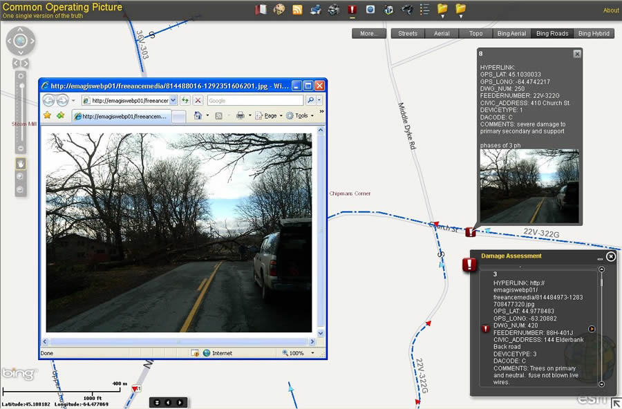
This image shows damage assessment points in the common operating picture as seen in ArcGIS with data collected via BlackBerry after a storm.
Using BlackBerry smartphones and Esri's ArcGIS software, NSPI crews are collecting precise asset and customer location information, along with data about customer connectivity and distribution system features such as transformers and disconnect switches. Data is collected using Freeance Mobile for BlackBerry software, transferred to the utility, and accessed via ArcGIS for Server. Technicians can then look at a common operating picture, developed in-house using ArcGIS API for Flex, and update the electrical model within minutes.
"We are building a more accurate picture of NSPI's distribution system, which has tremendous benefit for operations and customer service," said Brian Shannon, NSPI's GIS Connectivity Project manager. "This is, at the heart, a customer-service initiative, although there's no question this project has returned measurable time and cost savings already."
A highly accurate electrical model will improve NSPI's outage management system (OMS), enabling the utility to better predict the impact of storms, dispatch line crews more effectively, and provide better information to customers and emergency officials during outages.
A Rocky Start
The province of Nova Scotia spans an area of 34,352 square miles, with the population dispersed between major urban centers and small coastal villages. Workers, either walking or driving, collect data for the project in urban, rural, and off-road areas.
At the start of the GIS Connectivity Project, Shannon foresaw a problem with the projected labor profile. He thought it was going to be close to impossible to complete the work on time. Shannon anticipated this because of an earlier small pilot program in which engineering students gathered data using ruggedized devices built specifically for field use.
"With the ruggedized units, students in the pilot program had to travel to and from local NSPI offices scattered throughout the province in order to upload the collected data to local computer terminals," Shannon said. "For the GIS Connectivity Project, allotting time to travel to and from these depot offices every day would significantly reduce daily productivity."
Because capital expenditure approvals for the three-year plan were in place, Shannon and his team had to make things work.
The ruggedized devices were capable of connecting to the NSPI network via modem. However, this method of connectivity lacked the required IT security control. Customer connectivity information is private data that requires secure encryption.

Data collection points, shown in green, are visible as they are being collected. Using the Google Street View integration, office personnel can see utility poles and lines.
NSPI needed a technology solution that met this security requirement. The utility had additional requirements too. The operators needed a simple way to coordinate multiple teams collecting data on handheld devices. The solution had to eliminate trips to an office to transfer data and increase the data process flow so as to reduce the amount of time needed to get data into the production environment. The utility also wanted to simplify the data-gathering process by using easy-to-understand forms and predefined values, thereby reducing potential errors.
The utility already used a BlackBerry platform for executive-level communications, and NSPI recognized that it already had a communications backbone in place that would allow it to move forward swiftly. The platform quickly emerged as the right solution.
"The Freeance GIS software for BlackBerry has provided an integrated business solution for our utility by improving speed and accuracy throughout our processes, including data collection in the field, updating the ArcGIS system, and approving system changes," said Richard Janega, executive vice president and chief operating officer at NSPI.
A welcome surprise for Shannon and his team was how well the smartphones stood up in field conditions and in every conceivable type of weather. "We have our BlackBerry Storms in OtterBox units, and we don't have issues in terms of durability," Shannon said. "In our experience, BlackBerry smartphones are very suitable for field use in rugged conditions. They stand up fine."
Numbers Don't Lie
Shannon identifies the linchpin of the GIS Connectivity Project as the ability to provide reliable connectivity in the field for immediate GIS server updates.
"We avoided the need for collectors to travel to local utility depots for data uploads each day," said Shannon. "This saved two hours per day for each of the 14 collectors. That translates into nearly $200,000 worth of labor savings."
The utility also reports significant direct savings in terms of hardware, software server, and licensing costs. The cost savings alone may lead to the GIS Connectivity Project coming in on or under budget, according to Shannon.
Reduced Errors, Increased Efficiency
Previously, personnel who noted discrepancies in the location or identification of features in the field had to manually record any new findings on paper diagrams and submit them to office personnel for manual updates to the model. Now field personnel simply fill out a GPS Collector form.
The form is configured with required fields and predefined values, and the integrated BlackBerry GPS automatically records the location. The record is saved and is immediately available to the GIS technician in the office, who verifies the data and updates the model within minutes. "Having the collected data transmitted directly to ArcGIS for Server during the collection process reduces errors and eliminates the turnaround time between data collection and submission to the GIS technicians for processing," Shannon explained.
He credits the ease of use of the GIS Collector as integral to these operational savings. "Our enthusiastic field collectors are not necessarily utility-experienced folks, yet they are accurately capturing the different components of our infrastructure," said Shannon. "We are giving them a basic orientation to what the field assets look like, and they are using drop-down lists from the custom forms, which improves data accuracy and avoids potential errors."
In addition to the operational and financial benefits, the ultimate payoff for NSPI is increased ability to deliver exceptional customer service. For instance, more accurate data in the electric system model means that outage locations are more accurately predicted and crews are dispatched more effectively.
"In large storms, where dozens of crews can be dispatched to make repairs, we can now stage the crews correctly to maximize performance, minimize logistical effort, speed resolutions, and ultimately benefit customers through quicker restoration," Janega said.